Canada’s vast size is reflected in the country’s varied ecosystems, wildlife, natural resources, and cultural diversity. Yet with a population of just over 40 million people, Canada accounts for only 0.5 percent of the world’s population. In other words, Canada has a lot of land- and water-based resources to develop and manage, with relatively few people to do it.
This is one reason why the Royal Canadian Geographical Society (RCGS) and its Canadian Geographic Education program, better known as Can Geo Education, place such great importance on geographic literacy—to help ensure that tomorrow’s Canadian leaders understand and appreciate their country’s land and resources.
“Having a fundamental understanding of the basic principles of geography is essential to being an engaged citizen and better understanding the world around us,” said Michelle Chaput, director of research and education for Can Geo Education. “That’s why we offer programs that aim to strengthen geographic education in the classroom.”
GIS Is a Key Part of This Effort
“More and more jobs in the next decade and beyond are going to involve GIS or geographic technology in general to address issues such as food supply, the environmental impacts of globalization, extreme events like fires, even our economic and political environment,” she said. “This is why GIS is essential to future careers for Canadian students.”
Esri Canada, Canada’s leading provider of GIS solutions, is a key partner in this effort. Last November, the RCGS recognized Esri Canada’s K–12 [kindergarten through 12th grade] Education Program for significantly contributing to advancing geographic literacy in Canada.
In 2019, the award was renamed for Alex Trebek, the late Canadian-American television personality, Jeopardy! game show host, and friend to the RCGS. A passionate advocate of geography and education in Canada, Trebek hosted the first Canadian Geographic Challenge in the 1990s, supported the opening of Canada’s Centre for Geography and Exploration, and served as honorary president of the RCGS.
Raising GIS Awareness in Canada’s Schools
Launched in 1987, Esri Canada’s K–12 Education Program has transformed how geography is taught in Canada by raising awareness of GIS as a powerful problem-solving tool for students and teachers. Through this initiative, teachers across Canada can access real-world tools that provide students with skills they can use throughout their lives. The program supports inquiry-based learning, helping students develop skills such as geographic literacy, spatial awareness, critical thinking, and analytical reasoning. “Through our K–12 Education Program, we aim to inspire the next generation of geospatial thinkers and problem-solvers,” said Jon Salter, Esri Canada’s director of education and research.
This effort supports Can Geo Education’s work by allowing access to cutting-edge technologies and accessible tools that are easily implemented in the classroom. Can Geo Education provides free geographic educational resources to more than 27,000 educators across Canada. The country’s largest geographical education nonprofit, Can Geo Education creates and supports student programs for its K–12 teachers, students, and parents. Using products such as ArcGIS Online, ArcGIS Pro, and ArcGIS StoryMaps, the Esri Canada K–12 Education Program provides hundreds of software tutorials and teaching resources with titles such as “Think Local, Eat Local,” “Locating a New Airport in Manitoba,” and “Woodland Caribou.”
Esri Canada’s K–12 Education Program has worked closely with Can Geo Education for more than 10 years, said Tong, noting that her team and Can Geo Education have very similar missions. “They have such amazing stories to tell, and we can help them tell those stories on an educational level, such as highlighting Indigenous knowledge using [ArcGIS] StoryMaps.”
A former classroom teacher, Tong said that although she loved having a direct connection with her students, “In my current role, I am inspired by being able to bring my passion for geography to teachers across Canada’s provinces. Teachers are often amazed when they find out that Esri GIS tools are available to use in their teaching, while students benefit from understanding how GIS can be used to solve where-based problems. We’re helping to bring geospatial awareness and excitement to schools across the country.”
Paul VanZant, chair of the Canadian Geographic Education Committee, confirmed the group’s contribution to geographic literacy in Canadian schools. “As a former classroom teacher, I’ve had experience with the Esri Canada K–12 team since the 1990s,” he said. “Many of my students went into GIS careers, and that was directly related to the teaching resources provided by this group. They’ve also been great supporters of Can Geo Education’s summer institutes and conferences. For example, they’ve adapted their work to fit our conference themes.”
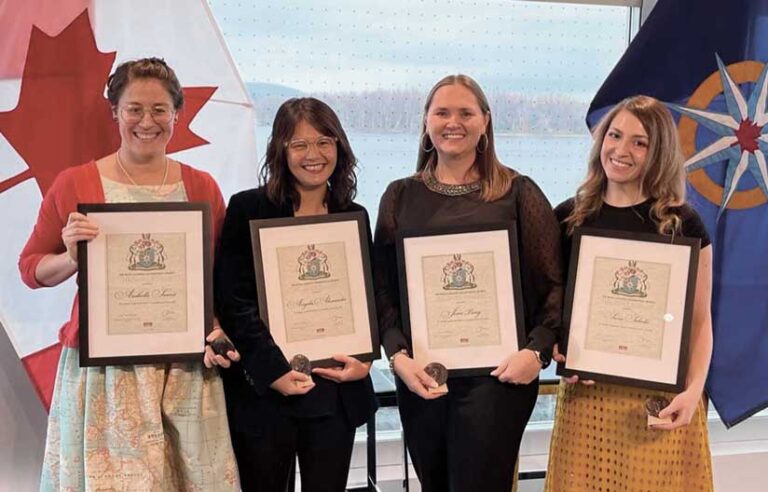
“I can’t express how proud I am of these four brilliant women. They are tireless advocates for GIS in K–12 education,” said Alex Miller, president and founder of Esri Canada.
For more information, contact Jean Tong at jtong@esri.ca.