When wildfires ravaged Lahaina, Hawaii, in August 2023, the scars left behind weren’t just physical but also emotional and societal. The subsequent challenges of conducting damage assessment underscored a pressing need for improved tools and methodologies. While traditional methods have their merits, the scale and severity of disasters such as the Lahaina wildfires demand something more efficient. In response, Esri developed a new damage assessment deep learning model.
Historically, conducting a damage assessment in the wake of a disaster has been a manual and time-consuming endeavor. Damage assessment teams need to cover vast areas—often under hazardous conditions—to document and assess damage. This not only elongates potential response times but also can sometimes result in inconsistencies due to the sheer scale of the disaster.
Esri’s damage assessment deep learning model was designed with the primary goal of addressing these challenges. By processing high-resolution satellite and aerial imagery, the new model can identify patterns of destruction, differentiating between damaged and undamaged structures. This automation speeds up the assessment process with surprising accuracy. This article provides a high-level overview of the associated workflow and where you can locate the model so you can start using it.
Practical Application in Lahaina
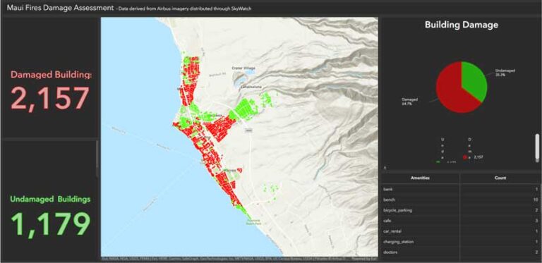
In the wake of the Lahaina wildfires, Esri developed and tested a new damage assessment model. The results were outstanding. What would traditionally take hours of labor and manual surveying was achieved in a fraction of the time with 95 percent accuracy. Rapid damage assessments with this level of accuracy revolutionize postdisaster assessment processes by providing access to previously unobtainable decision support information during initial response. For instance, with rapid and accurate damage assessments, authorities can prioritize areas for search and rescue and allocate resources to heavily affected areas immediately.
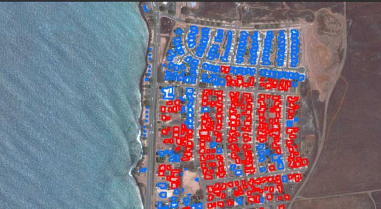
To classify damage, it is necessary to have building footprint information for the area of interest. This information allows the damage assessment model to classify buildings as damaged or undamaged by creating boundaries from which to reference and label.
The accuracy of the building footprint layer is also important and may vary depending on the method used to create the data. The building footprints should be accurate to the incident imagery that will be used to run the model.
If building footprints don’t exist, predisaster imagery can be used with different artificial intelligence (AI) models to extract building footprints. Esri offers a high-resolution model, Deep Learning Model to Extract Building Footprints, which is available from ArcGIS Living Atlas of the World. To provide additional context for the buildings, the building footprint data that indicates building occupancy type allows the model to help quantify the number of homes and other types of infrastructure that may be damaged.
After obtaining building footprint information, the next step is to locate postdisaster imagery for the affected area. Postdisaster imagery can come from a variety of sources including satellites or unpiloted aerial vehicles (UAVs) or drones. While obtaining postdisaster satellite imagery sounds difficult or prohibitively expensive, it is actually neither. Visit the SkyWatch and SkyFi websites to learn how easy it is to task satellites. Another great resource for postdisaster imagery is Maxar’s Open Data program. [Both SkyWatch and Maxar are Esri partners.]
Once postdisaster imagery is obtained, it is best to refine the deep learning model. For the Lahaina wildfire assessment, Esri manually inspected 500 buildings from the postdisaster imagery, classifying them as either damaged or undamaged. This helped refine the model for different geographies, account for differences in building size and shape, and incorporate different extents of damage into a model’s output. A drive-by or windshield survey augmented the postdisaster imagery to help the model classify buildings.
Once the model is refined, users can run the deep learning model in ArcGIS Pro or ArcGIS Online and produce their own damage assessments. Esri published both the results of the analysis and the deep learning model in ArcGIS Online in hopes of spurring efficient collaboration, creating new tools for incident response, and democratizing geospatial artificial intelligence (GeoAI). The Esri Damage Assessment Model is publicly available.
The model’s results can easily be placed into a web map, dashboard, or web app, depending on the user’s need. In the case of the Lahaina fire, a dashboard was chosen so that the results could be visualized and organizations could use it to help guide response and recovery efforts as well as inform public outreach.
The Way Forward
The tragic wildfires in Lahaina served as a stark reminder of the vulnerabilities we face and the importance of timely and accurate postdisaster assessments. Like most AI applications to support wildland fire response, deep learning doesn’t replace on-the-ground verification and expertise. It is a tool that augments human capabilities.
As wildland fire and disaster management continues to evolve, blending these models with traditional methods will only serve to improve disaster response mechanisms. As technology progresses, the goal remains steadfast: to support communities in their time of need, ensuring that they have the best tools at their disposal for disaster preparedness, mitigation, response, and recovery.