ArcGIS Pro 2.5 gives you more control over mapping and lets you perform tasks more efficiently using familiar workflows. This release incorporates many customer requests and items submitted to ArcGIS Ideas.
Mapping Improvements
ArcGIS Pro 2.5 improves production workflows to streamline and standardize map production, meet mapping agency requirements, and provide more control over the final product that meets or, in some areas, exceeds functionality in ArcMap.
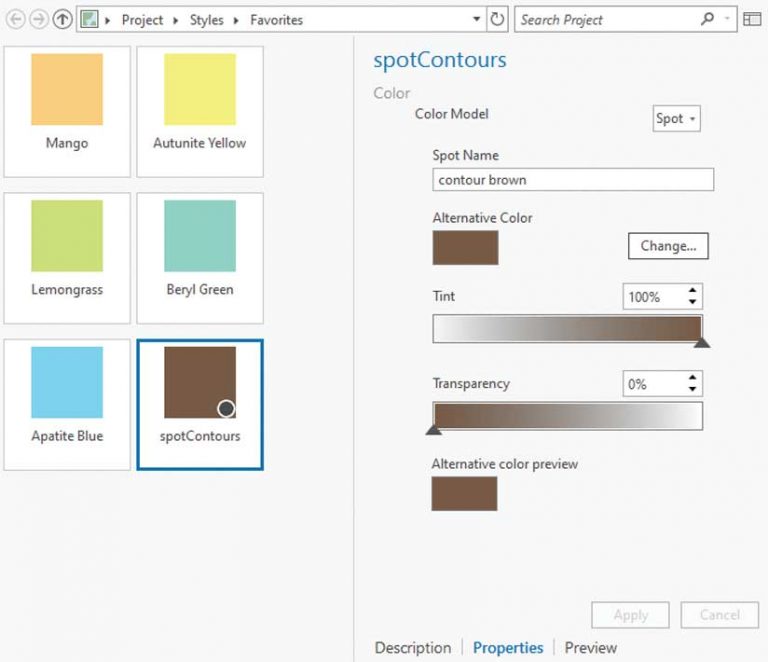
ArcGIS Pro 2.5 supports professional map production with color management that lets you control the reproduction and conversion of colors. Color management settings in ArcGIS Pro support ICC profiles and ensure that the colors specified for a map are rendered consistently across devices. Because color management is an application setting, it is applied to every map, layout, report, or style you create. Offset printing features—such as defining spot colors to specify the use of custom inks or overprinting on the symbol layer—are now available.
A new export type, Adobe Illustrator Exchange (AIX) format, has been added for use with the ArcGIS Maps for Adobe Creative Cloud extension. The extension converts vector and raster map content into editable, layered artwork that can be opened and edited in Adobe Illustrator. These files can be used for high-end graphic design or map finishing workflows and migrated across the other Adobe Creative Cloud applications.
The Match Layer Symbology To A Style tool is available in ArcGIS Pro at all licensing levels. It matches symbols to feature attributes in an automated fashion and is a big time-saver when mapping detailed datasets with standardized symbology such as US Geological Survey data.
Perform QA/QC on densely labeled maps more easily in ArcGIS Pro 2.5 with the new Lock Labels capability. When this is turned on, labels are not reconfigured when zooming the map extent, and label placement can be reviewed in both map and layout view.
Three new map projections have been added: Adams square II projection, Tobler cylindrical I, and Tobler cylindrical II. The Tobler projections were implemented in ArcGIS as the 100th and 101st map projection algorithms in honor of cartographer and GIS pioneer Waldo Tobler.
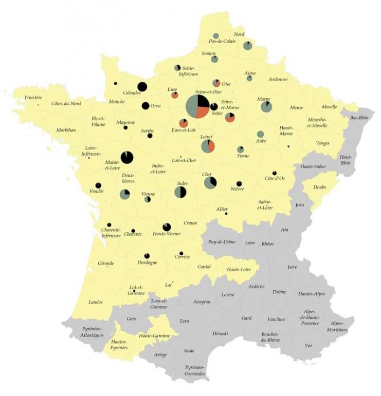
More options for visualizing attribute data are available in ArcGIS Pro 2.5 using chart symbology, which has been added for point, line, and polygon feature layers. Chart symbols can be pies, bars, or stacked bars. Each part of the chart represents one attribute value. Chart symbol size can be fixed or be determined by an attribute.
Now that all symbol properties for embedded symbols are available, you can construct an exact color scheme for point symbol halos, gradient fills, and gradient strokes. All symbol properties for embedded symbols used to symbolize elements within a shape marker symbol layer can be accessed, modified, and saved to a style for reuse.
Vertex editing tools let you edit text blocks in a layout for clarity and design purposes.
Improved Productivity and Performance
Browsing for and opening files on local and network shares is much faster. Among many performance improvements at 2.5, ArcGIS Pro is more responsive to symbology and selection changes, snapping, and identity requests.
Update tables more efficiently using the new find and replace in table view capability to find content in a table, make mass updates to tables, and identify and replace invalid values in a table.
Drawing enhancements include a more efficient level of detail (LOD) selection algorithm in 3D scenes that is tuned to balance high-resolution versus low polygon count features based on distance from the camera. Scene layer drawing allows faster loading and drawing of I3S content. LAS dataset loading and drawing speeds are greater, so frame rates are higher for the same volume of data. Chart data is rendered faster and asynchronously, and charts with axes have zooming and panning functionality.
Decide which layout will be most effective for your map using the new Layout Template Gallery. It lets you choose from the 12 predefined layouts that come with this release. Alternatively, you can customize the Layout Template Gallery by setting a path to the file containing your organization’s layout templates.
Get more done with export and print dialogs that now work in the background so you can continue working while those processes are taking place. For the first time, you can also set export size in pixels for your map view and verify that the map has the desired extent and aspect ratio using Show Preview.
Exporting a ModelBuilder model to a Python script has been improved to help you learn how tools and environments are used in Python and to edit and use the export as a stand-alone file. Export to a Python file or a Python window has been enhanced at version 2.5.

Geodatabase Replication Added
This is the first release of ArcGIS Pro that includes geodatabase replication capabilities. Replication in ArcGIS Pro will resemble the process in ArcMap and will require traditional versioning. Geodatabase replication lets you create copies of data across two or more geodatabases so changes to the data can be synchronized. For example, this allows an organization to disperse data maintained in a geodatabase as needed from its central server to its regional or local offices by replicating all or a portion of the geodatabase. As the replicas are updated, changes are coordinated between the offices through a synchronization process.
Geodatabase replication supports other workflow options in addition to those offered through traditional versioning. These workflow options can include supporting both production and publication versions of geodatabases; centralizing data from many sources into a central repository; allocating data management responsibilities in organizations that share them across different groups; and accommodating contractors who provide periodic updates to a geodatabase. The tools provided for geodatabase replication include Create Replica GP tool, Synchronize Changes GP tool, and New Replica Manager.
These are just a few highlights from the many improvements to ArcGIS Pro at the 2.5 release. Other improvements were made in parcel management, 3D visualization,
high-fidelity visualization, and in ArcGIS Pro SDK for the Microsoft .NET Framework. For a complete list of ArcGIS Pro 2.5 enhancements, see “What’s New in ArcGIS Pro 2.5” in the documentation.