Lawless litterers beware.
The New Jersey Department of Environmental Protection (DEP) created and hosts a GIS-based crowdsourcing app that lets New Jersey citizen volunteers report and map cases of illegal dumping of debris throughout the state.
The app uses Esri ArcGIS technology, works on Apple or Android devices, and links to the web app hosted by DEP. The app lets people specify the type of debris dumped such as construction or hazardous materials and the size of the pile. They can take a picture of the debris with their smartphone and upload the photo. They can also then use their device’s GPS to capture the location where they discover the debris and add the information to a map. DEP staff can then view the crowdsourced reports of dumping in ArcGIS Online.
“Because volunteers are using the GIS web app to report illegal dump sites, we can understand what’s happening,” said Arthur Zanfini, administrative analyst with Compliance and Enforcement for the State of New Jersey Department of Environmental Protection. “We can see the reports on a map, along with truck routes, transfer stations, or recycling centers. Then we can easily see correlations between dump site locations that clues us into what is happening.”
Sprucing Up New Jersey
DEP has a long history of using innovative ideas to keep the state clean. Each spring, thousands of people gather to clean up litter during the Barnegat Bay Blitz in Barnegat Light on the Jersey shore. Since 2011, local volunteers have been turning out to participate in the one-day blitz sponsored by the DEP.
The community was truly engaged in this environmentally worthy cause, but unfortunately, their efforts were being undermined. Volunteers soon realized that they had been cleaning up the same sites year after year. The wanton waste disposers returned to these areas and dumped garbage onto the newly cleaned landscape. It was time to make a stand.
The department launched the Don’t Waste Our Open Space initiative to reduce illegal dumping in state parks and wildlife management areas. GIS is a driving technology for this initiative. The Don’t Waste Our Open Space campaign task force is composed of numerous DEP agencies including representatives from Compliance and Enforcement, Water Resource Management, the state parks service and police, conservation officers, New Jersey Natural Lands Trust, and DEP’s Bureau of GIS (BGIS). The team’s objectives are to incorporate strict enforcement of illegal dumping laws while raising awareness of the dumping problem.
“We had people from the department sit down at a table and figure out a strategic way to work with what we have to attack a problem in our state,” said Zanfini. “We leveraged the Esri platform to aid in our effort.”
For decades, DEP has been using Esri products. Its enterprise platform is essential for sharing responders’ data about environmentally sensitive areas. With the platform already in place, it was natural and cost-effective for the task force to rely on it as a core technology for meeting the campaign’s goals: encouraging public participation in the project, changing people’s perceptions about illegal dumping enforcement, and catching offenders.
Engaging Citizens
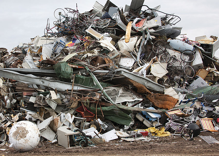
Public lands throughout New Jersey have become dumping grounds for litter, garbage bags, tires, televisions, electronic waste, appliances, yard waste, and construction debris. Illegal dumping threatens the local environment, wildlife, and the public. Moreover, it detracts from the natural beauty of public land, decreases property values, and costs the citizens of New Jersey tax dollars for cleanups.
The banner on the DEP’s Stop Illegal Dumping website is “Don’t Walk by While Your Park is Trashed.” Citizens can use the crowd-sourcing app that enables them to take action by taking geotagged photos at illicit dump locations. They can send this image to the DEP along with incident information that they enter on the app’s form.
At each state park, DEP displays posters about dumping laws and enforcement. These posters include a QR Code that links to the informative “Don’t Waste Our Open Space” landing page. The website tells visitors how to report illegal dumping to the DEP via the GIS web app on their smartphone browsers. App users can also use their cell phones to call a 24-hour hotline and make a report. GIS tracks the coordinates of reports and posts them to a map so that investigators know exactly where to find evidence.
Catching Offenders
Citizens use the crowdsourcing app to report incidents such as trash bag dumping, leaking tanks, or dumpsters that contain hazardous materials such as asbestos shingles. Having photos and GPS coordinates helps authorities respond quickly.
When a user hits the Submit button, an automated workflow begins. The app automatically writes the report and sends the photos to a feature service. At five-minute intervals, a Python script, run as a Windows task, checks the feature class to see if any new entries have been submitted. GIS processes categorize location reports to determine if they are within the state boundary, a state park, or a municipality and note if other illegal dump sites have been reported within 500 feet during the last two weeks, which may indicate this is a duplicate submittal.
The web app report triggers an alert that lets DEP staff know about an alleged case of illegal dumping. If the incident is on state property—within a state park or wildlife management area—the report goes to the DEP’s communications center for investigation. Staff members send an email alert to the appropriate authorities for follow-up. If they send an email to the park police department, the incident is automatically logged into the department’s dispatch system.
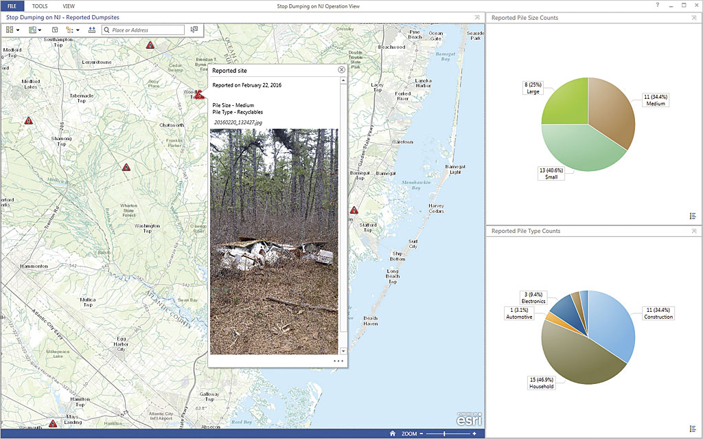
The ArcGIS Online map shows the reported locations of illegal dumping, along with the date of the report, so that investigators can analyze relationships and patterns. The image shows the magnitude of the incident so staff can prioritize responses. Photos show items at the dump site that may reveal whether the materials came from a nearby facility. Maps provide additional insight, such as the number of reports generated along a section of railroad track or a truck route.
Changing Perceptions
In a preproject survey, DEP discovered that most people do not believe that New Jersey enforces its dumping laws. The task force knew that its mission would not be successful if it had to rely on its small number of enforcement officers to decrease dumping on more than 814,000 acres of state land. It had to be smart. To deter potential perpetrators, it had to change the community’s perception by proving that laws are enforced and offenders are prosecuted.
To convey this message, the team published an Esri Story Map app that shows the pictures of offenders who have been caught and the maximum fines they could face for their offenses. The map template lets DEP staff easily update photos and information.
Measuring Success
You can’t tell if a program has succeeded or failed if you don’t measure results. From the inception of the project, the DEP task force set up success indicators and established baselines for comparison. For example, the results of the initial public survey provided a baseline for measuring the program’s ability to change the public perception that laws are not enforced. Perception can be measured over time. The number of reports submitted by the web app from recreational hikers and other park visitors is also a success indicator.
Mapping the number and location of arrests for illegal dumping over time makes it easier to understand data about law enforcement success. Furthermore, analysts can determine which arrests were related to citizen reporting. Mapping data from the Barnegat Bay Blitz cleanup day will show if volunteers find less trash in previously high-trash areas and will indicate if dumping activity has decreased. This is also a good way to advertise the effectiveness of the event.
Within the first few months of its trial launch, volunteers have already been using the app. It will take DEP a few years to gather the measurements that will show exactly how effective the Don’t Waste Our Open Space program has been.
Locating More Opportunities
Zanfini is happy to spread the word about the GIS dumping solution and talk with other agencies interested in implementing similar projects. Crowdsourcing apps are also helping citizens participate in other action-oriented projects. For example, the DEP created a reporting app that members of the AmeriCorps NJ Watershed Ambassadors Program use to collect and report the stream data necessary for keeping waterways clean. Community volunteers use a DEP web application to verify the locations of public access to the New Jersey coastline. Their work contributes to a map that makes the shore open to everyone.