The burden of administering elections falls primarily on local government. The legal framework and some oversight for elections are provided by the federal and state governments, but counties do all the work of running every election. The enormity and complexity of this task are typically underappreciated. Local governments are responsible for elections held for administrative areas that range from the local to the federal, and cover school districts; special districts such as water, sewer, storm, sanitation, and community service areas; and municipal and county districts.
Ballots must be tailored based on where each voter lives, which is why the task of verifying voter addresses and precincts is so critical to the operations of a county elections office. In many cases, ballots must be provided in other languages, in addition to English. The Orange County Registrar of Voters (OCROV) provides translated ballots in Spanish, Vietnamese, Chinese, and Korean, and facsimile ballots in Tagalog and Farsi (Persian). For each voter, the county elections office must identify the federal, county, state, municipal, and school district and any other jurisdictions in which that voter resides, determine how many of each type of the ballot to print, and distribute the ballots correctly.
OCROV is using GIS to improve how the county handles the complex tasks associated with running elections. In the 2018 General Election, it provide the appropriate ballot to every one of its 1.6 million voters. To that end, 385 ballot types were created.
The mission of OCROV is “To provide election services for the citizens of Orange County to ensure equal access to the election process; protect the integrity of votes; and maintain a transparent, accurate, and fair process.”
The individual at the helm of the OCROV is its registrar Neal Kelley. The process of optimizing OCROV efficiency and improving the voting experience has been championed by Kelley, who joined the county as Chief Deputy Registrar of Voters in 2004 and was appointed Registrar of Voters in 2006. Despite only having a staff of 65, the office tries to be at the forefront of elections departments at the state and national level by working with agencies such as the California Association of Clerks and Election Officials (CACEO), Department of Homeland Security (DHS), and the Federal Bureau of Investigation (FBI).

Smoother Operations
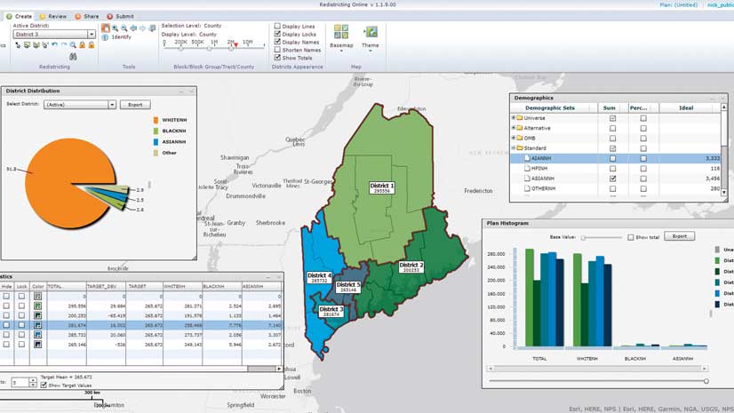
Since 2016, OCROV has greatly expanded the use of GIS in its operations and planning for elections. The widespread use of GIS to improve election management, piloted in the 2016 election cycle and refined in the 2018 cycle, has greatly enhanced the speed and efficiency of many operations at OCROV including verifying addresses.
In 2016, the OCROV GIS team was tasked to modernize all voter addresses by geocoding them and verifying the location of precinct boundaries in advance of the 2016 presidential election. This was not a trivial task.
Although some digital mapping of precincts had been done previously by OCROV, the list of voter addresses was based on paper reports. In the past, it could take months to review and verify voter addresses. By cross-checking voter addresses with address data maintained by the water department and assessor’s office, OCROV could verify that addresses were both valid and correct. Currently, OCROV maintains more than 800,000 addresses, and now the process of verifying them takes weeks, not months. This process has ensured OCROV would not face the problems other county registrars have experienced caused by inaccurate addresses that can lead to the nullification of election results.
In addition to assisting with verifying voter addresses, an internal ArcGIS Online tool identifies polling places that need volunteers and which polling places need language support. Other ArcGIS Online tools help OCROV track the delivery and return of equipment used at polling places. These tools allow OCROV staff to spot deficiencies and misallocations of resources.
GIS has been especially beneficial when OCROV is working under the time constraints imposed by special elections, which require preparing maps and materials for a subset of the county’s voters. In February 2019, OCROV needed to modify half the county’s precincts in just a three- to four-week period. OCROV quickly accomplished these tasks for 300,000 voters—tasks that would have previously taken months.
GIS has improved not only the preparation for elections but also the county’s execution on election night. In pre-GIS days, OCROV verified that precincts had reported via phone, which was a staff-intensive process that took a significant amount of time. Time is something that OCROV does not have on election night, since all ballots must be returned to OCROV on election night. The return of ballots following the closing of the polls on election night is mandated by law.
Now, instead of having every precinct call in, Operations Dashboard for ArcGIS is used to verify the status of polling places and track the return of machines containing electronic ballots known as Judge’s Booth Controller boxes (JBCs). JBCs are the control unit of the Hart InterCivic eSlate Voting System. A combination of Survey123 for ArcGIS, ArcGIS Pro, and some Python scripting is used to accomplish this.
Operations Dashboard lets Kelley see the status of all aspects of an election. GIS tracks the location of JBCs in real time, verifying that election night procedures are being followed. A series of milestones are recorded—polling place closure, JBC en route, and JBC received and processed—documenting that JBCs are being returned. Throughout this process, the locations of all vehicles simultaneously returning JBCs from polling places are tracked. During the 2018 General Election, 984 JBCs were tracked. The Orange County Sheriff’s department works with OCROV to ensure the secure return of JBCs from the collection centers to OCROV.
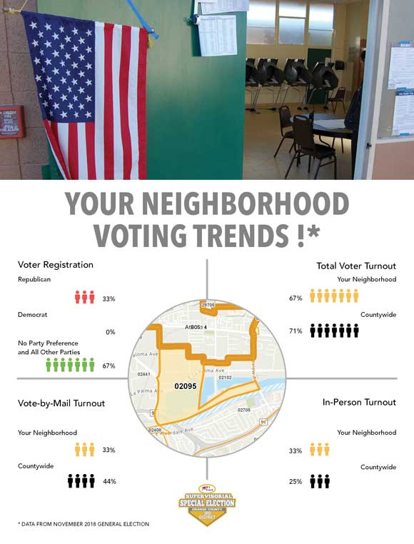
OCROV uses GIS not only to better run elections but also to inform the public, encourage voter participation, and provide easier access to election results. Using spatial analysis, OCROV produces posters showing voting trends by neighborhood. An Esri Story Maps app, “30 Days of Data for the 2018 Primary Election,” maps a wealth of information not only about how elections are held but also on voter characteristics and behavior.
The Your Voter Registration page on the OCROV websites uses GIS behind the scenes to provide voters with the correct polling place, information on the districts in which they reside, and information about their elected officials. Voters can also use the site to apply for a vote-by-mail ballot, download a sample ballot, or opt out of receiving a sample ballot. These outreach efforts have had a positive effect: the turnout for the 2018 midterm election hit a historic high of 71 percent.
Meeting New Challenges
More challenges constantly arise for OCROV. In 2016, the county conducted an Early Vote Center pilot program and in 2018 increased the number of these centers with a mobile pop-up Early Vote Center. In the March 2020 Presidential Primary Election, absentee ballots will be mailed to all voters, the county will open full-service Vote Centers in many more locations throughout the county that will operate on weekends and extend the period to cast a vote in person beyond the traditional one day of voting on election day.
OCROV is making extensive use of the spatial analysis capabilities of ArcGIS Pro to help OCROV meet these new requirements. Analysis of available structures means the county will not have to consider all possible locations when locating Vote Centers—just the ones that meet the 14 state-mandated criteria under Senate Bill 450, which is also known as the Voter’s Choice Act (VCA). Since OCROV must give reasons why it picked each of the Vote Center locations, this analysis provides the rationale for OCROV’s choices. Utilizing GIS will continue to provide data-based analysis to inform the OCROV operations planning and assessments.
About the author