The work of GIS professionals in the city of Jihlava in the Czech Republic benefits staff in departments across the city, communities in the surrounding area, and city residents. A regional center in the middle of the country, Jihlava has a population of 50,000 and is surrounded by hills in an area of natural beauty. It is located in the Jihlava District, which encompasses 78 towns and villages.
GIS staff not only maintain current landownership records used by many city systems but also enhance communication between different parts of the municipal government, the public it serves, and between towns and villages in the Jihlava District.
At the beginning of each month, Jihlava’s GIS staff members eagerly await the release of new data from the Czech Cadastre Office. When they receive this data, they check changes that occurred the previous month and begin a process of using this data to update various map apps, the city’s internal IT systems, and property maps.
By connecting current land records to other municipal records, they can create maps of ownership and identify parcels that have special legislative limitations. Combining land record layers with planned projects, green infrastructure, and other layers enables better decision-making.
Helping Colleagues
It’s a typical Monday in the GIS office. Someone from the Urban Planning Office calls. Urban Planning is going to issue legal statements on which the building authorities will base the zoning permits they will issue. They also need to check how these statements have been completed. Can GIS help with these tasks?
“I like these projects the most,” said Jana Havlícková, GIS specialist at Jihlava. She likes them because by working together, GIS staff can create an app that will solve the problem while making things easier for colleagues in other departments.
A quick brainstorming session produces a wireframe for the new map app. Six building authorities in the Jihlava district will use a feature layer accessed from ArcGIS Online to view legal statements as well as create and maintain zoning permits. Through ArcGIS Online, privileges can be managed so staff in all offices can see the data, but only those who have created the data can edit it. Editor tracking helps monitor the data life cycle.
The mapping application should provide users with all available data so that the zoning permits can be considered in a spatial context. Current and proposed zoning plans, utility data, parcels, and other important data should be included along with the operational layer. GIS staff use Web AppBuilder for ArcGIS to actually create the app.
However, the work on the app is not yet done until the app creators consult with end users to ensure that the app meets their needs. If not, adjustments must be made. However, in this case, once users appreciated how much information they could access, they felt the app would solve their problem.
This cooperation extends beyond the town. According to Havlícková, “Work with GIS is about cooperation. You can have a perfect system, but it means nothing without people who are using it.” Jihlava invited other cities in the surrounding area to join the Jihlava Geoportal, share data, and use the great tools the ArcGIS platform provides to work with their data.
Constantly Innovating
The GIS department works to keep up. It is continually testing new tools, entertaining new ideas, and reflecting on how these innovations can help staff in other departments. Deploying mobile apps in common workflows was one result of this process. For example, the municipal police use Explorer for ArcGIS to access information about parcels, addresses, streetlights, traffic signs, and other aspects of the city.
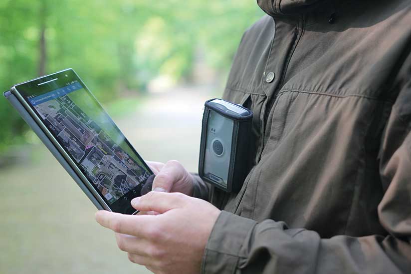
Collector for ArcGIS is extensively used by the Department of Environment. Its ability to communicate with external GPS receivers is important for identifying parcels. Workers from the State Administration of Forests use Collector for ArcGIS to identify parcels marked as forestland. Using a Global Navigation Satellite System (GNSS) receiver, they can track their position deep in the forest with submeter precision enabling them to quickly navigate and complete their tasks without requiring surveying.
Better Communication with Citizens
While helping city staff and those from surrounding municipalities benefit from GIS is a priority, communication with citizens is equally important. The GIS department especially wants to provide tourist information in a useful and attractive way. Instead of trying to compete with Google or Mapy.cz, the staff focused on presenting information in a simple, intuitive fashion that used the minimum number of tools but still provided information in an interesting way. This led Jihlava to adopt Esri Story Maps apps.
Havlícková said GIS staff were charmed by the simplicity of story maps, which also provided a variety of ways to present information. After looking at all the templates, they chose the Map Series Tabbed template to create their first story map, a simple tourist guide showing various points of interest and tourist trails on separate tabs. “But we didn’t stop here, and we created more thematic guides—one for public transport in Jihlava, another for recycling waste containers, one that showed places to walk with dogs, and many more,” said Havlícková.
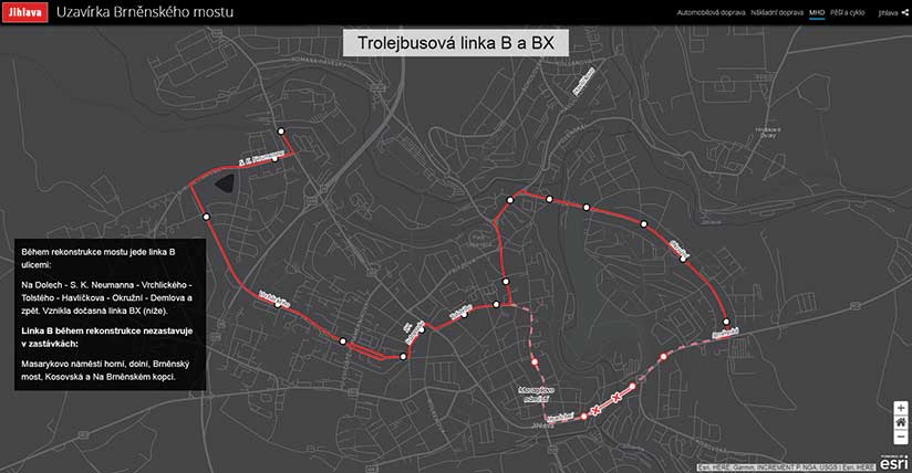
In the beginning of March, the staff faced another challenge. A bridge on the important road leading through Jihlava had to be repaired, which would cause traffic congestion and affect public transport lines. The GIS department had to communicate the road closure and the detours to the public. It decided to use the Story Map Cascade template. The story map provided a detailed guide for both motorists and pedestrians, explained how the closure would affect the public transport lines, and showed alternate routes for both light and heavy vehicles. The app was successful. In the first month, it was accessed more than 2,500 times.
Actively Engaging the Public
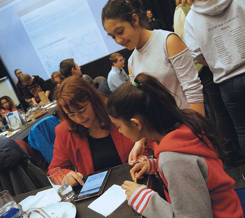
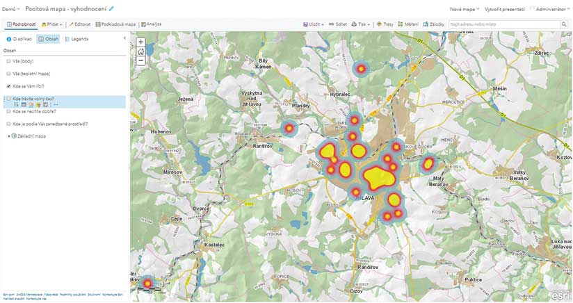
Instead of simply giving information to citizens, GIS staff wanted to involve the public. An opportunity to do that was the Emotional Map made for the Forum of Youth. Previously, Emotional Maps were paper maps created in ArcMap. People could put color stickers on the map showing places they liked or disliked.
This year the Emotional Map was created with the help of Survey123 for ArcGIS. Using the interactive form, members of the public could choose an emotion (“I like it here,” “I go there in my spare time,” “I am not comfortable here”) and put it on the map. At the Forum of Youth, children from elementary and high school could use tablets to contribute to the Emotional Map online. At the end of the event, they could browse the map and explore various areas symbolized as colored points and heat maps that showed the capabilities of GIS. Visitors to the Healthy City forum could also add their inputs to the Emotional Map.
Last year, Survey123 for ArcGIS was used for the city transport survey. Citizens could choose a transportation type, locate and describe problems, and suggest solutions. This yielded 500 responses, identifying both problems and solutions that served as the basis for the new sustainability mobility plan for Jihlava. This proved that engaging the public captures valuable information.
Variety Keeps Things Interesting
Havlícková notes that the work of the GIS professional isn’t limited to creating and distributing apps. GIS staff make sure apps fill the needs of their colleagues and manage technical support. In addition to tackling interesting new projects, they must perform routine tasks such as data management, source preparation, data exporting, communication with users, training, support, and popularizing the use of geospatial information. She believes this variety in tasks is one of the best things about a GIS professional’s job. She never knows what interesting projects and collaborations the new month will bring along with new cadastre data.
For more information, contact Jaroslav Škrobák at jaroslav.skrobak@jihlava-city.cz.