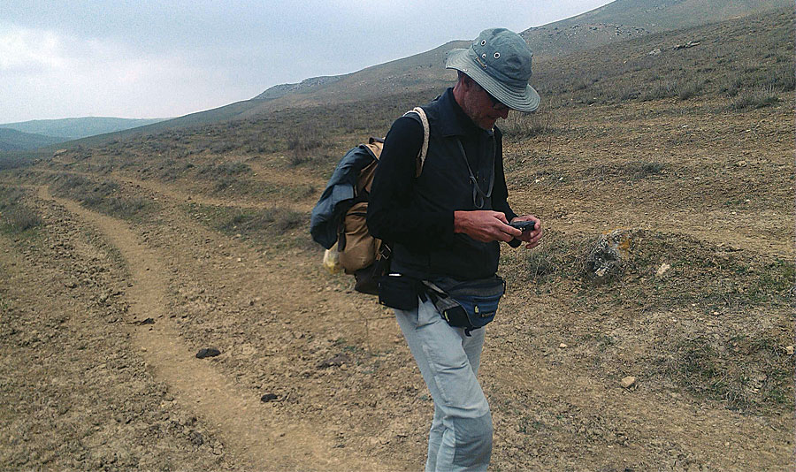
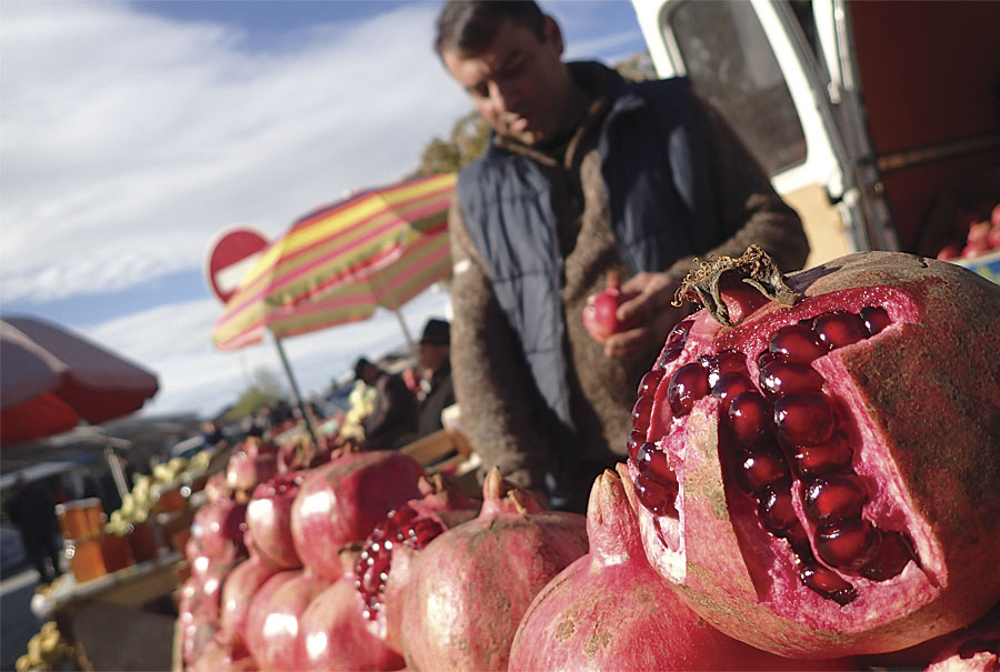
It’s the middle of the night in Baku, Azerbaijan. American journalist Paul Salopek sits in his room in a cheap hotel—a former shoe factory—where he’s at work on a story about his encounters with people along the contested border between South Ossetia and the former Soviet Republic of Georgia. As 3:00 a.m. approaches, Salopek reconstructs a scene in which an old woman passes him a bowl of food through the concertina wire marking the boundary separating Georgia and the breakaway region. The simple tableau adds a layer of what Salopek calls “human texture” to a piece set against a complex backdrop of long-standing and violent conflict.
Salopek is three years into the Out of Eden Walk, an eight-year journalistic project in which he’s retracing—on foot—the path of prehistoric human migration. In the process, he is writing about the people he meets and the cultures he experiences. Salopek’s journey began in January 2013, in Ethiopia—widely considered by archaeologists to be modern humanity’s point of origin—and has, thus far, taken him north, across the Red Sea to the Arabian Peninsula and into the Levant and the Caucasus. From Azerbaijan, Salopek will travel east, across Asia, then cross from Siberia to North America, and continue south, ultimately arriving at the southern tip of Chile, some 21,000 miles from his starting point in east Africa.
Embracing a “slow journalism” approach—with narratives built on impromptu encounters and the quiet, daily lives of his subjects—Salopek produces articles and photography for the project’s website and for National Geographic magazine. Geospatial data figures heavily in Salopek’s storytelling. Maps serve as illustrations for many of his dispatches, while stand-alone maps offer substantive sidebar material that puts his travels and experiences in a clear geographic context, a narrative element Salopek considers vital.
“This is a journey through four dimensions,” the journalist says, referring to both the project’s historical emphasis and the timeline of his own journey on foot. “It would be poorer if it lacked navigational aids to the storytelling.”

Mapping for the Out of Eden Walk is produced using the ArcGIS platform by Harvard University’s Center for Geographic Analysis (CGA), a service-oriented institution that promotes geospatial thinking and technology within the Harvard community. Jeff Blossom, a senior GIS specialist with CGA, serves as the project’s chief cartographer.
“Our mission is to support research and education that uses geographic information,” Blossom says. “[The Out of Eden Walk] is education focused, with a great deal of entertainment value. The maps and photography are intriguing, and Paul’s writing style is incredible. With his ‘slow journalism’ element—inviting people to take an introspective look at the world—[the Walk] is right on target with what CGA does: using maps to educate people.”
CGA occupies a small set of ground-floor offices in Harvard’s Knafel Building, a modern glass-and-terra-cotta structure a couple of blocks from the campus hub of Harvard Yard. The center, which opened in 2006, offers GIS consulting, training, and tool development for the university’s students, faculty, and staff. With a team of 10 full-time GIS specialists, CGA’s efforts range from the creation of maps as instructional aids to geospatial data management for research projects and grant proposals.
Salopek, a recipient of two Pulitzer Prizes for his work as a foreign correspondent, was on the Cambridge, Massachusetts, campus in 2012 as a Nieman Foundation visiting fellow, finalizing plans for the Out of Eden Walk, when he approached CGA staff about a potential support role for the project. Blossom was intrigued with the concept of the long-form, immersive storytelling on which Salopek’s strategy would center.
“It runs contrary to the way typical journalism works,” Blossom says. “Typically something happens, and journalists fly in, cover it, and leave when it’s done. They get a superficial view but not a deep understanding of what’s going on. This would be an effort to extract deeper meaning of the events going on in these places.”
Salopek characterizes the approach as one rooted in the pursuit of on-the-ground authenticity. “We’ve all read stories set in different cultures that are clearly written by writers who’ve parachuted in,” he says. “They strain credulity because they rely on easy tropes and assumptions, familiar conclusions, and metaphors. When you walk through a community—as opposed to zipping through it—telling details emerge that inform a deeper, broader picture.”
The journalist envisioned mapping as a storytelling component on the Out of Eden Walk, Blossom recalls. Cartography would offer not only a means of documenting a route but also a tool for adding context to Salopek’s work.
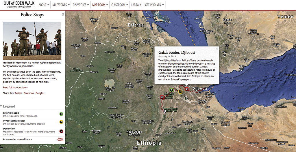
In the partnership that’s developed, Salopek and Blossom communicate frequently by phone and Skype, discussing ideas for thematic maps each time the journalist transitions from one region to the next. Concepts can range from the deadly serious, such as the history of forced migrations in the Middle East, to the lighthearted, even quirky—like the continually updated map detailing the many instances in which Salopek has been stopped by police. Other ideas come spontaneously, a reality that Salopek embraces, given the ways in which geopolitical realities complicate a global journey.
“Borders and politics are the biggest obstacles to walking [around] the world,” Salopek says, “not predators or glaciers or droughts as was the case with our ancestors who first left Africa. I’ve been blown way north into central Asia because of visa delays. So be it. It’s part of the journey.”
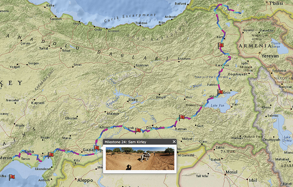
Blossom uses ArcGIS for Desktop, ArcGIS Online, and Esri Story Map apps to build thematic maps for the Out of Eden Walk. Among the most prominent maps he’s created for the project is its stagesetting graphic, The Greatest Walk, which illustrates the path of prehistoric human migration, set against an image of the ground surface that would’ve been exposed 70,000 to 100,000 years ago, an effect Blossom achieved by using Esri’s bathymetry and topography layer to expose mapping of the earth’s terrain between sea level and 100 meters below sea level. Subsequent storytelling maps detail specific chapters of regional history on the Out of Eden route.
“Paul wanted a map that told the story of how civilizations have been pushing each other back and forth through [the Levant] since Neanderthals and Homo sapiens first met,” Blossom says. The result, a multimedia effort called Turbulent Origins was created using ArcMap among other programs. It illustrates “how civilizations have struggled for territory, from Mesopotamian wars to current conflicts.”
Other thematic maps place Salopek’s journey against the backdrop of a region’s history. Blossom used ArcGIS Online to create an interactive map of Saudi Arabia, contrasting Salopek’s path through the country with historic Muslim pilgrimage routes and the campaigns of British archaeologist and military officer T. E. Lawrence, the famed Lawrence of Arabia.
The project’s financial supporters are recognized in another of Blossom’s efforts. The Out of Eden Walk has grant funding from the John S. and James L. Knight Foundation, which supports journalism and media innovations, but has also earned grassroots backing through a Kickstarter campaign. Each donor can sponsor a mile of Salopek’s route. Using ArcGIS Online, Blossom created a donors’ map highlighting sponsored sections of the walk. Segments are labeled with donors’ names.
Blossom’s other assignments from Salopek have included maps examining the timeline of prehistoric human migration, the challenging topography of Ethiopia’s Afar region, and the highlights of walking through such cities as Jerusalem; Tbilisi, Georgia; and Jeddah, Saudi Arabia.
From the perspective of GIS professionals, Blossom says, the Out of Eden Walk has offered a powerful illustration of the discipline’s utility as a journalistic tool. The ability to link a story, an interview, or a particular moment to a specific point on the globe, he says, dramatically empowers storytellers.
“The biggest impact I see is the promotion of the map as a way to tell stories,” Blossom says. “And that’s not just for GIS professionals. Anyone with a computer and Internet access can make a map and tell a story.”
Blossom’s work with the Out of Eden Walk has inspired him to create tutorials on such topics as geotagging smartphone photos and using a smartphone’s GPS functionality to create data for use in story maps. These efforts are aimed at both professional journalists and amateur storytellers.
Such cartographic elements, Salopek asserts, provide readers with the benefit of greater context—geographic, geopolitical, and historical—with the net effect of bringing an audience closer to a journalist’s subjects. Whether he’s writing about the cultural importance of pilgrimage route sor the ways in which Somali piracy hampers scientific research in the Indian Ocean, Salopek adds that a strengthened sense of place provides a layer of storytelling that would be difficult to replicate without GIS mapmaking tools. Geospatial angles, he finds, contribute to the complexity that makes a story more compelling.
“[This] is an experiment to increase mindshare online,” Salopek says, “not via the usual levers—clickbait, jellybean journalism—but by trying to hook an audience into longer-form, more immersive storytelling. Things get more complex. And that’s the way it should be.”
About the author