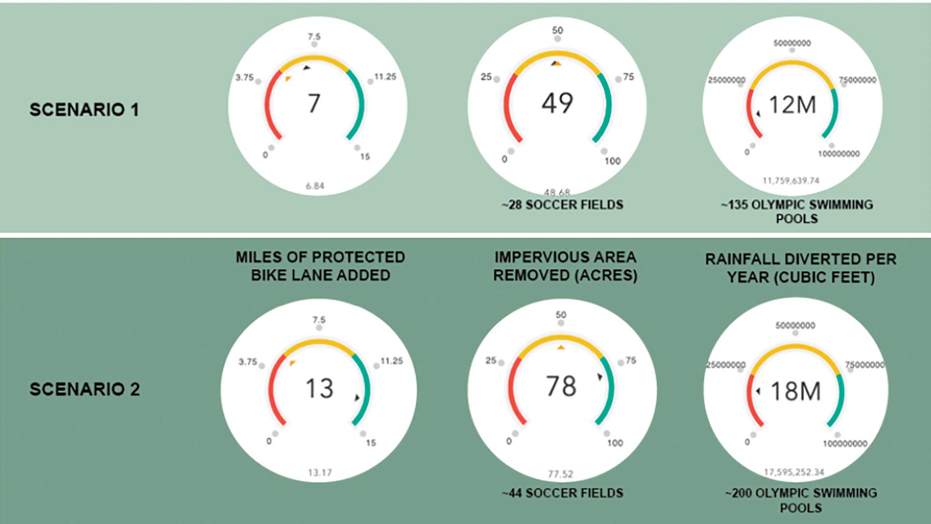
Research by students and faculty members at two German universities led to the development of indoor mapping and routing apps that help students and staff members navigate complex campuses.
As longtime Esri institutional license users, both the University of Applied Sciences Würzburg-Schweinfurt (FHWS) and University of Applied Sciences Dresden (HTW) offer students geoinformation-related degree programs. Students from both universities explored the use of ArcGIS Indoors to create a common operating picture of university buildings for navigation, routing, and location sharing resources university-wide.
“Indoor mapping is a common topic for all universities, because we all have campuses where we spend a lot of time, especially indoors,” said Jan Wilkening, education coordinator for Esri Germany and a professor at FHWS since 2019. “And it is fun for students to cover this topic in a bachelor thesis, because they focus on their everyday life and not on something that is abstract or far away.”

Exploring the Possibilities of Indoor Mapping
As campuses continue to grow, the universities will need to address indoor navigation demands for students and staff. One option is integrating a campus information system with ArcGIS Indoors. A project led by Rainer Schäffner, an engineer at FHWS, has been investigating techniques and applications for indoor navigation technology since 2014. He has developed a campus navigation system using ArcGIS API for JavaScript.
“We [had had] our own campus information system for about five years, and I was curious about comparing and testing the techniques of Esri, about data modeling, and about the possibilities I later saw in the indoor positioning system,” Schäffner said.
Schäffner offered indoor positioning systems as a research topic to several students for their projects or bachelor theses. Together, Schäffner and his students explored the capabilities of ArcGIS Indoors.
They looked at data for a building in ArcGIS Indoors and compared it to the data for that same building from the campus information system Schäffner had developed. The building used for the research is complex and comprises five structures from different construction eras. Making these comparisons involves exchanging data between the two systems to perform accurate modeling of the building.
Then Schäffner began preparing the campus network for routing and for making prototypes. The goal is to enhance the existing FHWS campus information system with improved functionality and capabilities provided by ArcGIS Indoors. New capabilities could answer questions such as Where am I? and How do I get to a specific room? Schäffner also sees the system being useful for finding assets. FHWS students and researchers can explore optimizing indoor positioning technology, implementing it and other applications using GIS indoors.
Schäffner and Wilkening agreed that ArcGIS Indoors provides several benefits that make working with it very attractive. One benefit is the ability to create web-based campus information systems. Another is the ability to investigate research questions such as which factors influence positional accuracy.
Joshua Porzler, who was pursuing a bachelor’s degree in geovisualization at FHWS, collaborated with Schäffner and Wilkening on his thesis, which focused on integrating the existing indoor positioning system (IPS) with ArcGIS Indoors on campus. Porzler’s design utilized between three and four Bluetooth beacons per room and corridor.
“Our campus is very complex. I think it’s a difficult environment, and I hope that the result will be an IPS which works so [that] new students or professors from other universities can find their way around our campus,” said Porzler. “You can learn a lot [about indoor mapping] from using ArcGIS Indoors and the function of IPS because there are many different solutions you can try, especially at a university.” Schäffner’s and Wilkening’s research on campus mapping is ongoing, but Porzler completed his thesis in April 2021.
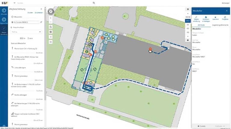
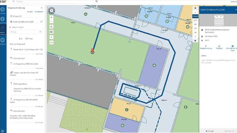
HTW student Ricardo Roch explored another use case for indoor mapping in his bachelor’s thesis, entitled “Building a Routable Network for Indoor Navigation with ArcGIS Indoors.” Like many complex campuses with multiple buildings and room numbers, wayfinding at HTW was challenging for students, faculty, and visitors. After seeing a presentation on ArcGIS Indoors, Roch realized the technology could be used to address the campus’s navigational challenges.
Within a 10-week period, Roch created a web and mobile navigation app for a campus building. He explored CAD drawings, Revit models, and 3D buildings in different data formats to determine the best one for visualizing information and publishing it on ArcGIS Online so it could be used by desktop and mobile wayfinding applications. His thesis project tested indoor mapping in both 2D and 3D and looked for performance differences between desktop and mobile devices. He incorporated a unique routing system for emergency escape paths and identified wheelchair-accessible directions. Roch’s work earned him the Esri Young Scholar Award Germany for 2020.
“It’s really brilliant to get an experience like this, to use this software in a thesis, and I like it because it’s a very intuitive tool,” Roch said. “Now I think it’s time to use this technology and to do more research on it. I see the future in indoor navigation because we can get our position outside precisely, but we are kind of lost indoors. Therefore, it’s time to use and prove these technologies.”
Roch completed his bachelor’s thesis in February 2020 and has entered a master’s program with University of Applied Sciences Dresden. For his master’s thesis, Roch plans to explore facility management with ArcGIS Indoors. He hopes that his bachelor’s thesis can serve as a starting point for other students who see the value in indoor mapping and want to apply it more widely.
Beyond Theory—What’s Next for ArcGIS Indoors
Both Roch and Porzler presented theses that showed how indoor navigation technology could meet wayfinding challenges on campuses and be expanded for use in airports and hospitals.
“I think it’s really good for collaboration and big research projects because ArcGIS Indoors has very good performance,” Roch continued. “For other students, I can say it’s so interesting to work with ArcGIS Indoors, and [I] recommend it. Don’t be afraid to use this software, because everything can work if you want it to, and if [you need assistance], you have Esri contacts at your university who can help.”
Porzler noted that if more universities explore ArcGIS Indoors for different projects, its functionality will grow as a result of student collaboration. But in a larger context, Porzler sees the technology growing beyond campuses, for business use as a cost- and time-saving tool.
“I think ArcGIS Indoors has a good possibility to improve building management and convenience for [other buildings] that many people pass through because of IPS—for example, airports, universities, conferences, hospitals, or train stations,” Porzler said. “It is a great solution, especially if they are already using Esri technology, and I think there will be a lot more functions in ArcGIS Indoors in the [coming] months, years, and decades.”
For now, both universities will continue to provide students with diverse research opportunities like indoor mapping as well as access to the latest GIS technologies to foster growth in the future of geoinformation and location-based sciences.