NC OneMap, Created with ArcGIS Hub, Is North Carolina’s Go-To Location for Geographic Information
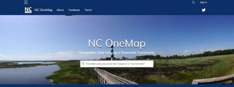
Organizations or individuals searching for authoritative North Carolina geospatial data or web apps can find what they need online at NC OneMap, a portal that was recently revamped using ArcGIS Hub from Esri.
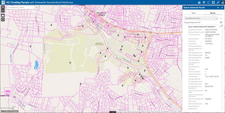
The revamped version of NC OneMap contains imagery and geospatial data on North Carolina parcels, demographics, transportation, energy, health, broadband access, and more. Users, including members of the public, can download datasets; access APIs; and use some of the featured web apps such as Imagery, Property Parcels, Imagery Seamlines, and USGS Topo Maps.
NC Geographic Information Coordinating Council (GICC) decided ArcGIS Hub would be the best fit for the next generation NC OneMap portal the council wanted to create. NC OneMap, which first came online in 2003, is maintained by the North Carolina Center for Geographic Information and Analysis (CGIA).
ArcGIS Hub is a cloud-based community engagement and collaboration platform that makes it fast and easy for organizations to share geospatial data, maps, apps, APIs, and other tools and resources.
The CGIA team members and many of their partners already use Esri ArcGIS, and the close integration of ArcGIS Hub with ArcGIS Online was an important factor in making their selection. “The ease of integration, ease of implementation, and ease of maintenance were key considerations,” said Brett Spivey, NC OneMap developer. “Pretty much everything we needed was already included with our existing [ArcGIS] license agreement.”
Before the new NC OneMap portal went live, CGIA invested time up front on content and site design and developed best practices for its partners who share data. The planning paid off: users get consistent results and better experiences, and there are fewer support requests than in the past.
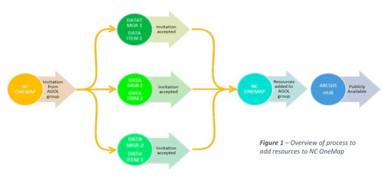
“ArcGIS Online is key to what we’re doing,” said Tim Johnson, CGIA director. “It gives us the tools we need to push our statewide orthoimagery and parcels to our users. Our state agencies, like the Department of Transportation and Department of Environmental Quality, can easily federate their data to the NC OneMap portal as well.” The best practices document describes this data federation workflow. Using ArcGIS Online, invitations are sent by CGIA to their partner data providers to join the open data group. Once the owner accepts the invitation and shares their data items with the group, it is automatically discoverable as public open data in the NC OneMap Hub application.
The team also wanted NC OneMap to be a secure collaboration space for CGIA’s numerous partners to share open data. Plus, with its small team, CGIA needed a solution that would allow it to quickly add content and easily maintain it.
Ease of Use
Since NC OneMap users range from novices to experts, CGIA wanted to build a site that most people would find intuitive. So the team decided to display the most useful content at the top of every page. “The thing we knocked around in the office a lot [was the question], Would our nontechnical customers be able to use the site easily and be able to find what they needed to find?” said David Giordano, NC OneMap database administrator.
Another goal of the NC OneMap project was to provide a reliable data search and discovery experience. At the very top of the home page, for example, the team included a search bar that says, “Find data using keywords like ‘imagery’ or ‘environment.'” The next thing users will see is a video tour to introduce them to the new site.
NC OneMap is an authoritative discovery point of statewide geospatial data supplied by multiple different agencies. To build consistency, the members of the CGIA team knew they also had to provide clear guidance to their data-sharing partners.
Several of CGIA’s state partners, large and small, already have their own ArcGIS Online organizational accounts, so that prebuilt infrastructure allowed for quick integration. Because North Carolina state agencies like the Department of Transportation and the Department of Environmental Quality were already using ArcGIS Online in a production environment, the decision to use Hub for NC OneMap was a win-win.
Beyond technology, CGIA team members knew that planning was critical to their success. Since it’s easy to start building pages, it’s vital to plan the site map layout before diving into development. Several years’ experience with the previous version of the NC OneMap portal gave the team members insight into their users’ needs and use patterns. The team approached the problem like a business, ferreting out how people would use the site and get the most functionality out of it. The team identified the pages that data customers were likely to come to the site for. The team members prioritized content and started laying it out in priority order on the web page. They explored different ways users would navigate the site and made thoughtful design decisions.
Next, the team considered the content from a customer perspective. “As a customer, if I enter a keyword such as ‘roads,’ then I should expect to get all results related to roads,” said Giordano. The team developed best practices for CGIA’s partners to follow when sharing their data with NC OneMap.
When partners provide a resource to the open data portal, one requirement is that they follow a standardized taxonomy system of tagging that resource. For example, all open data will have the NC OneMap tag, other tags associated with International Organization for Standardization (ISO) topic categories, and any other tags the data owner decides to include. The North Carolina GIS community already creates good metadata with ISO keywords, so following these accepted practices is relatively easy.
Time invested on the front end has paid off. The site’s organized content builds confidence and delivers a clean and consistent user experience. Partners follow best practices for sharing content, which improves the overall discoverability and usefulness of the information that individual departments are providing.
People such as foresters, engineers, land surveyors, and real estate agents go to NC OneMap to look for data. CGIA responds to their feedback.
“The proof is in the pudding, with the comments I’m reading from people who use [NC OneMap] and the data that’s in it,” said Spivey. “One of the litmus tests that we use in the office is the positive feedback we receive from people who are not GIS professionals but who use GIS periodically in their jobs.”
Fewer Questions, More Answers
While the previous platform served users well, CGIA is pleased that there are fewer questions about how to search and find data than there were in the past. With NC OneMap 2.0, customers know what to expect and can easily find what they need.
Since launching 17 years ago, NC OneMap has served as a reliable statewide geospatial data portal. When used by decision-makers, the portal enhances public safety, informs government decisions concerning transportation and the environment, and increases economic vitality in North Carolina communities. Numerous partners—including local, state, and federal government agencies; the private sector; and academia—have been involved and contributed to the project.
NC OneMap, promotes a vision for geospatial data standards and best practices; data currency, maintenance, accessibility, and documentation; and a statewide GIS inventory. It comprises 37 priority data themes, including statewide orthoimagery and aggregated parcel data from all 100 counties in North Carolina plus lands belonging to the Eastern Band of Cherokee Indians.
To read more about NC OneMap, see this case study.
Wondering how cities, states, and regional government organizations are using ArcGIS Hub to help agencies work more collaboratively on shared initiatives and goals? Visit ArcGIS Hub Example Gallery.