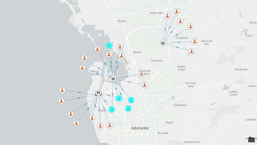
From Dropped Calls to Coverage: GIS Drives Rancho Mirage Wireless Plan
Officials drove city streets to map areas with weak cell service. The results—displayed on an interactive map for residents—impelled change.
June 2026

Officials drove city streets to map areas with weak cell service. The results—displayed on an interactive map for residents—impelled change.
There’s been a storm in Brooklyn, and some trees need trimming. Guide these efforts by modifying a web map and customizing a feature layer.
Esri’s director of conservation solutions details various career paths and the skills graduates need to succeed.
Discover practical ways to advance your GIS career, from publishing content to creating a portfolio of your work.
Predictive data visualization, powered by geospatial technology, is helping officials plan new buildings and renovations in Hawaii.
New apps for data collection—Survey123 Mobile and Survey123 Studio—introduce capabilities that improve productivity and usability.
The role of GIS is expanding beyond traditional fields, enhancing teaching, research, logistics, and planning in higher education.
Committee and caucus meetings, educational workshops, and general sessions focus on county responsibilities and domestic policy issues.
Easier access to data and improved spectral analysis tools help users move quickly from raw data to meaningful results.
Extend existing workflows beyond the hardware available in your office and confidently scale production with new cloud support capabilities.
Learn how recent timeline and knowledge graph improvements help users identify persons of interest in a fictional criminal organization.
A GIS-based mapping platform supports coordination for each phase of the SunZia project life cycle, from construction through operations.
Operational dashboards and GIS technology enhanced situational awareness, enabling officials to shift quickly from planning to action.
Firefighters document their work in the field on mobile devices and share data to create a common operating picture of fires across the US.
This instructor-led course shows you how to build immersive web apps that feature your organization’s content—without writing code.
This new massive open online course (MOOC) explores a holistic framework for building and sustaining a successful GIS program.
In this web course, learn about the properties of a utility network, along with essential editing and tracing workflows.