North Carolina’s population has grown by 8.9 percent since the 2010 Census, spurring a surge in business, new construction projects, and the expansion of existing properties like universities. Because a large portion of that real estate is state owned or managed, the State Property Office—which provides professional real estate services for all state agencies within North Carolina—has long maintained an online, public-facing inventory to keep track of these properties.
The site allows users to view state lands and properties for sale and lease, the status of specific transactions, what the current inventory looks like for state-owned properties, and whether a building has been accepted into the state’s inventory, plus a wealth of other information. This database is an invaluable, centralized resource for state agencies and state-affiliated individuals who may not otherwise have a clear picture of the size and value of their own inventory, information that can help them make crucial budgetary decisions about where and how they operate.
However, until recently the site existed only in the form of a text-based search engine. This site was difficult to update with changes in the state’s inventory and included no visual component for state agencies to get a holistic look at what they actually owned and how they could use, buy, sell, or lease their real estate.
Deciding it was time for an overhaul, the State Property Office partnered with design and technology firm Patrick Engineering Inc. to build a new web-based inventory system using ArcGIS Experience Builder.
An Evolving Inventory
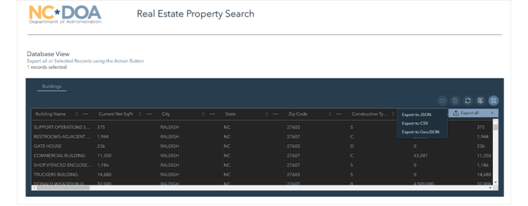
While users could query the database to find information on the more than 11,000 state-owned buildings and about five million square feet of leased space, it lacked a visual or geographic component, and users couldn’t export records from the site.
“We had to develop a new interface to tap into that [geographic] data,” said John Cox, facilities information section manager for the State Property Office. “The original site for searching and querying was text based, so it didn’t have a map viewer as a part of the page.”
The goal was to develop the new site with ArcGIS as its backbone, using Cartegraph software to integrate with the ArcGIS system, explained Charlie Charping, a GIS consultant with Patrick Engineering. Cartegraph is designed to help organizations manage physical assets and operations.
“Since that data was already in [the right] format,” said Charping, “it just made sense to have the public-facing site tap directly into that data, instead of some complex process to get it back into the legacy system.”
Patrick Engineering aimed to tie the data back to the State Property Office’s real property management system to ensure that users could obtain near real-time information. This would also enable the office to update the site more easily.
ArcGIS Experience Builder not only came with an embedded geographical component in being integrated with ArcGIS Online, but also gave Patrick Engineering more control over the layout of the site compared to other solutions. The intuitive learning curve allowed the team to complete the process quickly without hiring additional developers or sacrificing the quality of the project.
Cox wanted the look and feel of the site to be similar in layout and navigation to the legacy system to provide a simple transition for users. The team assembled a group of other state agencies to view the test site and provide feedback on the look and feel of the page.
Embracing the New
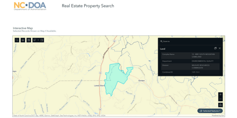
The new Experience Builder site has improved the user experience with enhanced capabilities such as exporting records and giving state agencies geographic context to their data. With 8,000 visits to the site over the course of seven months, usage has increased, and the site now gives users details on their current inventory. The map allows users to see building locations, a notable improvement from the previous system.
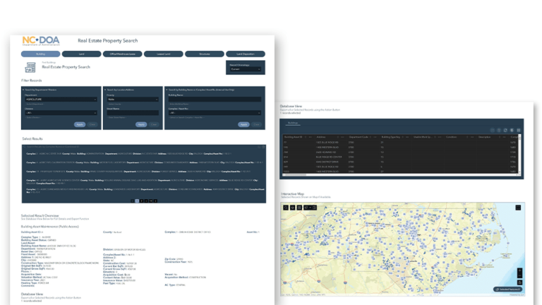
The site, which is also now viewable and fully functional on mobile devices and tablets, is composed of multiple pages sorted by property and asset type. Predefined queries mean users can search by department, county, street address, or building name. Once a result is selected, the map will zoom to that area and highlight it.
The site has empowered users to obtain the data they need on their own, without assistance from the State Property Office. “Once the users were fully trained and they learned how to use it, it reduced calls and inquiries to me directly,” said Cox. “It’s helped my job and my staff serve the state agencies and the public with information.”
Charping also noted that the ability to customize the site’s layout with Experience Builder has allowed users to interact more efficiently with the data than they could with a text-based search.
“[I liked] the flexibility to place elements on the page wherever you want them to be, and the ability to really create more of a full website, not just a single map viewer,” said Charping. “It opens up the floodgates for GIS professionals to be able to produce something that is based on GIS but—as the name [says]—is a whole experience.”
About the author