
ArcGIS StoryMaps has long been a versatile medium for providing meaningful context to the work of GIS professionals. Now, in addition to ArcGIS StoryMaps, Esri’s storytelling offerings have expanded to include the simply named StoryMaps, which launched in April 2022. StoryMaps allows non-GIS professionals to share their personal experiences, travels, and more to a broader audience.
StoryMaps has two subscription plans: a basic one that is free and a premium one that offers a wider array of features, such as multiple layout options, unlimited stories and collections, mapping capabilities, and custom themes. Storytellers can integrate audio and video elements alongside the text-based, interactive mapping features familiar to users of ArcGIS StoryMaps to create stories that are both immersive and personal.
Users have latched onto StoryMaps for a variety of reasons and purposes, from narrating road trips to sharing hobbies to planning adventures.
“It’s a good tool even if you’re not doing a map,” said Todd Nelson, a blogger who has used StoryMaps to cover subjects as diverse as his Amtrak travels and the history of the Shafters, a wealthy 19th century American family. “It’s graphically oriented, [it’s] got a lot of punch.”
Nelson, a bicyclist and history buff, is familiar with other online mediums, but he found StoryMaps to be the most versatile avenue for approaching the geographic and image-heavy pieces he gravitates toward.
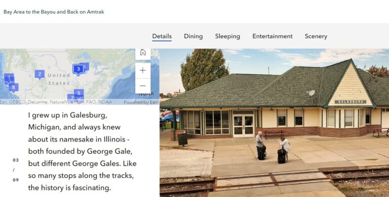
“The nice thing about the platform is I can just do a paragraph that’s got a map associated with it and then present the text [differently] in the graphics,” he added. “There’s always something in there that is useful to portray that way.”
Nelson has also used the medium to map the gravesites of the Ohlone as well as his many adventures by bicycle.
Designed as a platform to bring geospatial thinking to an audience not necessarily mired in the world of GIS, StoryMaps also presents itself as a practical choice for applications beyond simply telling stories.
For instance, Brian Pessolano used StoryMaps to organize the Great Train Race, an event for runners 17 years old and younger in Fredericksburg, Virginia.
“[It’s useful to be] able to help the parents understand the geography,” said Pessolano. “The challenge with the race is we have three different distances. It helps to be able to lay that out so people know where their kids are going to end up, where their kids need to be to start.”
This is Pessolano’s second year directing the race, which has been held annually for 28 years and can pull in around 1,500 runners and 100 volunteers. Previously, participants simply received a PDF containing locational information prior to the race. The interactive nature of StoryMaps has made a significant difference in terms of how that information is communicated.
“I want to make sure I provide people with [multiple] avenues to get all the information they need, because it’s a complicated event,” said Pessolano. “The younger kids that are eight and under, I have to make sure I put them back with the right adult. There are all sorts of safety [guidelines] that we follow. It’s a lot of moving parts.”
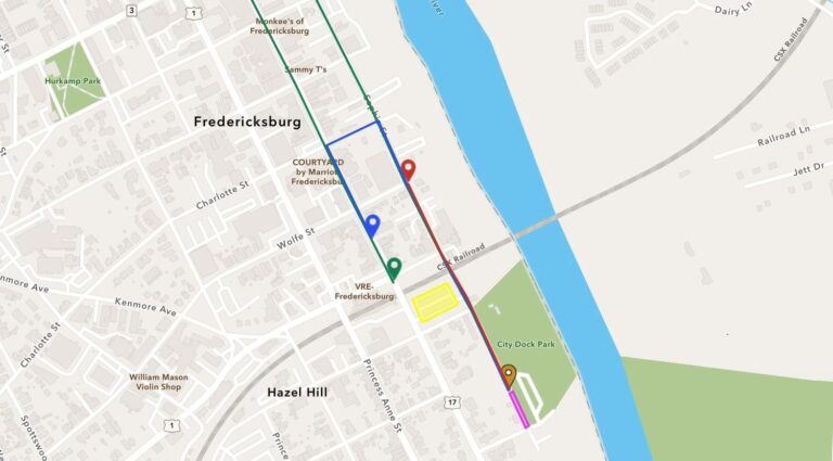
Pessolano noted that StoryMaps was a practical choice to convey that kind of visual information to both participants and their guardians even before the race begins.
“Some of these [participants] are pretty young,” he said. With StoryMaps, “they can actually step through and [see] what the course looks like. They can see pictures of the streets. It could be a way for some of the parents to get the kids comfortable with what they’re going to see on race day.”
And it was simple for Pessolano to implement his vision. “Overall, it’s super intuitive,” he noted. “Once you understand the different components that you can add, it’s very easy.”
And the practical application for StoryMaps extends beyond blogging and event organizing.
“From a tourism perspective, I think there’s all sorts of really cool ways you can use StoryMaps,” said Tara Anbudaiyan, a marketing consultant who has integrated the platform into her business. “It’s an easy way to build an immersive experience, whether you have a map or not.”
Anbudaiyan uses StoryMaps as a home for in-depth travel guides, walking tours, and itineraries for her clients, using multimedia elements including photos and maps to present a clear picture of different destinations.
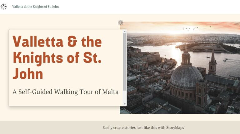
“Having an interactive map is so important for the end user,” said Anbudaiyan. “[Clients are] able to visualize where they’re going, how it relates to other places in the area.”
Although these StoryMaps users represent the myriad of ways to take advantage of the platform, what’s common is their focus on StoryMaps as a medium that puts its visuals first.
“You can write those [stories] in sentences, but it just has so much more impact if you can see it on a map,” added Nelson. “I think [immersion] is a very good word for what the tool is doing. You’re trying to overwhelm people with the visual.”
Users are enthusiastic about continuing their StoryMaps journey, envisioning ways to share their travels and hobbies in new and different ways.
“Absolutely I will continue to use [StoryMaps],” said Anbudaiyan. “I [will] shout from the rooftops: ‘Everyone should have this.'”