Emerald Isle, North Carolina, Uses GIS to Make the Yard Debris Collection Process Efficient and Transparent
A web mapping app created using Esri technology gives residents of the Town of Emerald Isle, North Carolina, a real-time, bird’s-eye view of where yard debris trucks are traveling along the route at any given time.
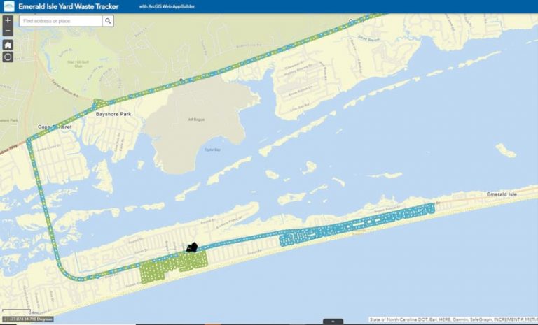
The Emerald Isle Yard Waste Tracker displays the location of the town’s two yard waste trucks on a map as the vehicles make their way through the community. It also shows the tracks of where the trucks have traveled since the start of the crews’ shift.
The public-facing app on the town’s website was rolled out in May 2021 in part to a demand by residents to better know when their yard debris would be collected. It was part of the coastal community’s new, wider, data-driven solution to better monitor and manage yard waste pickup—the process of collecting, transporting, and disposing of yard debris such as leaves, grass clippings, tree trimmings, and other plant material.
“This new system will improve our level of customer service and will aid our staff when filing yard debris pickup reports,” said Artie Dunn, public works director for the Town of Emerald Isle.
Where’s the Yard Debris Truck?
Emerald Isle, a beach town and island in Carteret County, sees its off-season population rise from less than 4,000 people to roughly 50,000 people from late spring to early fall. This places a great demand on services like yard waste pickup, which the town offers at no additional cost.
In recent years, the town has received calls from residents who wanted to know why their yard debris hadn’t been picked up on time. Like many coastal communities that rely on tourism as the main industry, the Town of Emerald Isle experiences an influx of owners of second homes and visitors during the summer and fall.
The Emerald Isle Public Works Department utilizes two trucks with two drivers to traverse the community, picking up yard waste. There are approximately 6,500 land parcels in the 5.6 square mile town.
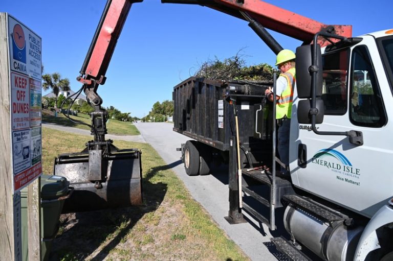
According to Dunn, the trucks make from 60 to more than 100 stops on a typical day. Once the vehicles are full, they leave the island to drop off the yard waste at a nearby landfill, then return to Emerald Isle to repeat the process. Crews take an average of two or three loads a day to the landfill.
During the off-season, this workload is manageable for the two public works employees and their trucks. However, during the peak times in the spring and fall, particularly after a severe weather event, the drivers may make just 25 stops to pick up large debris piles, and up to four truckloads may be taken to the landfill in a single day.
That’s when town staff members start to receive calls from property owners who are wondering why their yard debris piles have been sitting by the curb for an extended period of time.
“Our residents in Emerald Isle, especially those that live on the island full-time, are used to our public works team easily managing yard waste pickup and providing them a service they expect will occur without interruption,” Dunn said. “However, with more and more people visiting the island in the summer months and an increase in severe storms along our coast, we can’t always keep up, no matter how hard we try. We knew we needed a better solution to meet the needs of our town.”
End of the Pen and Paper Era
For years, the town’s public works department tracked its waste debris operations using pen and paper, with crews filing out spreadsheets with information such as the number of debris pickups they made each day, where they traveled, the daily mileage, and how many trips they made to the landfill.
The workers would file the reports with Dunn at the end of their shifts. Dunn would then have to spend about 45 minutes compiling that information into his own report, which he would email to town staff at the end of each day. While it was an effective process, it was also time consuming and made it difficult for the public works department to quickly analyze information and trends. And when residents called the town’s administrative offices to find out why the trucks hadn’t picked up their yard debris yet, it was difficult to track down those details.
“I needed people to see that we are running eight hours a day, and there is really nothing more we can do,” Dunn noted.
For a solution, Dunn and town manager Matt Zapp turned to Greg Flinn, an independent GIS consultant and licensed small unmanned aircraft systems (sUAS) pilot. Flinn uses GIS solutions and aerial imagery to support local municipalities and governments, including for crisis response during natural disasters. Due to its geographical location, Emerald Isle is prone to tropical storms and hurricanes.
After brainstorming with Dunn and conducting extensive research, Flinn thought that a digital solution based on Esri technology would work best, and town leaders agreed.
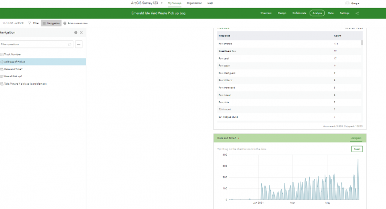
The Emerald Isle Yard Waste Tracker was developed using ArcGIS Web AppBuilder and ArcGIS Tracker and is hosted on ArcGIS Online. A separate dashboard that Dunn uses to monitor yard waste pickup and gather data for reports was created using ArcGIS Dashboards, with the information populating that app coming from data collected using ArcGIS Survey123 and ArcGIS Tracker.
Before developing the solutions with GIS, Flinn first did a deep dive to understand the yard waste pickup process, riding along with the drivers and talking to Dunn about the information required for his reports. “I needed to understand every data point along the route that had to be captured electronically,” Flinn said.
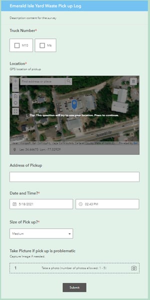
Flinn designed two forms in ArcGIS Survey123 for the truck drivers to fill out. One included information that needed to be collected at each stop—the address coordinates (captured via GPS on the tablet) and the load size (small, medium, or large)—as well as an option to add a photograph of the yard waste (if there was a pickup that violated a town ordinance).
The second ArcGIS Survey123 form Flinn created was an end-of-day report that the drivers needed to fill out that included their truck’s daily mileage and how many trips they made to the landfill. The drivers access both surveys on their location-enabled Samsung Galaxy tablets.
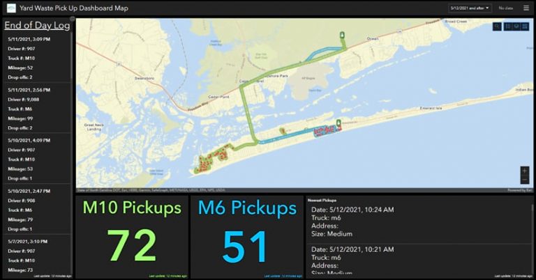
The information gathered on the forms is added to a layer in ArcGIS Online and can be viewed in real time using ArcGIS Dashboards. Dunn can then easily see the daily mileage, number of pickups, and number of drop-offs at the landfill. With the digital data collection, he can now easily share this information with the town administrative staff as needed with a quick screen capture.
In the future, analyses also can be done on the collected data to see trends and answer questions such as, Where is the greatest demand on the island for yard waste pickups?, according to Flinn.
Flinn also made it easy for Dunn, town staff, and the public to access and view the real-time location of truck crews. He used ArcGIS Dashboards and ArcGIS Tracker to display the data captured by ArcGIS Survey123.
Dunn can see the location of the trucks in real time and where they have traveled each day—and over time—by glancing at his dashboard, while the public sees the same information in the Emerald Isle Yard Waste Tracker app.
The app provides government transparency, helping Emerald Isle residents gauge when their yard waste may be picked up by public works staff. Yard debris is collected from 8:00 a.m. to 3:00 p.m., Mondays through Fridays, but exact pickup times for residents vary on a weekly basis depending on various factors such as distance traveled and the size of yard debris piles.
So now, instead of calling the public works department to ask when their debris will be picked up, residents can go online and see the trucks’ locations for themselves. Staff at the town’s administrative offices are hailing the Emerald Isle Yard Waste Tracker app, which helps them quickly answer people’s calls about yard waste pickup times.
Flinn said the app gives administrative staff a snapshot of where the trucks are at the moment and where they have been that day, helping them to answer callers’ questions faster.
“Transparency between the Town of Emerald Isle employees and our residents is one of our top priorities,” said Dunn. “Now, we not only have the ability to perform annual and seasonal analyses, but we can give our residents visibility into how hard we work, along with real-time updates, and make decisions based on data. It’s a win-win for everyone.”
Zapp agreed, noting the solution will not only help during regular seasonal pickups, but it will be useful following a severe storm when the town needs to provide information to the Federal Emergency Management Agency (FEMA). This information is to show the extent of storm damage throughout the town, which is needed for FEMA assistance.
“By utilizing the [solution that] Greg has created for us, this will allow us to quickly analyze information following severe weather and collect data that will then be released to FEMA following a storm,” he said. “Greg has gone above and beyond in his work. We are thrilled to have him working with the Town of Emerald Isle, so he can help us improve our services and communication with our property owners and residents.”
