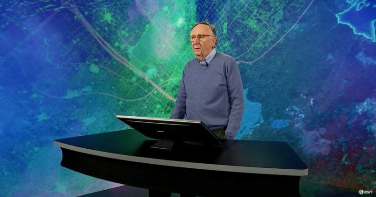
Esri President Jack Dangermond Calls on GIS Professionals to Help Create a Sustainable Future
Esri president Jack Dangermond says that the vision and theme of the 2021 Esri User Conference (Esri UC)—GIS: Creating a Sustainable Future—was inspired, in part, by words he read in Why INEGI? The Saga of a Mexican Institution in Search of the Truth. The book by Mario Palma, a founder of the National Institute of Statistics and Geography (INEGI) in Mexico, stresses the importance of the organization’s role as an independent provider of statistical and geographic information in a democratic society.
Palma wrote how the lack of understanding of reality was one of the greatest risks that every society faces and that the future depends on creating and applying understanding.
“These were the beacons that started INEGI; but these words speak to me because they are a purposeful way of describing our work [as GIS professionals]: creating and applying understanding,” Dangermond said during the Esri UC, which was held on July 12–15, 2021. About 71,000 people registered for the virtual conference.
The world, according to Dangermond, is a complex and highly interdependent ecosystem undergoing rapid changes, mainly due to human activities. “Geologists are starting to call this the Anthropocene Epoch, where humans absolutely dominate the history, the life, and future of our world,” he said. “Today our world is being challenged because we, as humans, are living recklessly and unsustainably. And this is threatening our future.”
Dangermond noted some of the problems we face: pollution, severe drought, racial injustice, pandemics, human-induced climate change, overpopulation, and a steep decline in biodiversity. Reversing course will require a deep understanding of the world to create a future that’s environmentally, economically, and equitably sustainable.
Creating a sustainable future will mean saving wildlands, developing renewable energy, conserving oceans, promoting equity, improving business efficiencies, scaling back consumption, and preserving and creating green infrastructure.
“Applying our best science, our best technology, and our best creative thinking will clearly be necessary,” Dangermond said. “And I can’t help but know that geographic thinking is going to be essential in this. Sustainability requires we see the world as one single ecosystem. Geography provides the science and language to do this.”
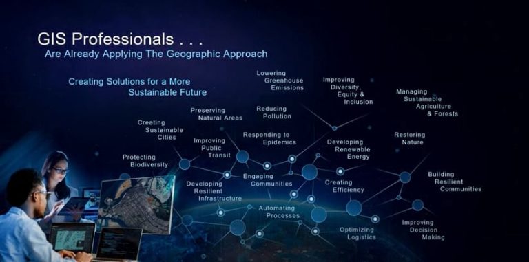
Dangermond lauded the work that audience members have already done using GIS—managing sustainable agriculture and forests; developing renewable energy; reducing pollution; responding to epidemics; improving diversity, equity, and inclusion; optimizing logistics; and protecting biodiversity.
“You are applying the geographic approach and creating so many solutions for a sustainable future,” he said. “However, we need to scale up our collective efforts exponentially. GIS technology can help us.”
Technology that supports the sustainability mission includes the following:
- GIS in the cloud
- Advanced spatial analytics
- Geographic artificial intelligence and machine learning
- 3D visualization
- Big data integration capabilities
- Imagery and remote sensing
- Interactive mapping
- Visual storytelling
Dangermond reiterated a message from past years about how geospatial infrastructure—an expanding, interconnected network of systems, services, and apps—makes data, apps, and maps widely available for sustainability projects. “This is helping us collaborate. It’s helping us share,” he said. “It’s transforming workflows and decision-making at many scales.”
With the myriad of sustainability issues society faces, there’s no time to waste putting forward GIS-based solutions, according to Dangermond. “I feel like I am all in, and I want to encourage you to go all in,” he said. “Act with urgency.”
Watch Dangermond’s GIS—Creating a Sustainable Future presentation in its entirety.
Four keynote speakers at the Esri UC outlined how they and their organizations are stepping up to advocate for and create a sustainable future. They were Wade Crowfoot, secretary of the California Natural Resources Agency (CNRA); National Geographic Explorer in Residence Enric Sala; journalist and National Geographic Explorer Paul Salopek; and La June Montgomery Tabron, chief executive officer (CEO) of the W.K. Kellogg Foundation (WKKF).
California Aims at Science-Driven and Nature-Based Solutions
Earlier this year, Esri and the CNRA entered into a collaborative agreement to build the CA Nature Geographic Information System (CA Nature GIS). CA Nature GIS, according to the agency, will synthesize data and information on biodiversity, climate change, public access, and other key factors.
During his keynote presentation, CNRA secretary Crowfoot spoke about CA Nature GIS and its role in supporting California governor Gavin Newsom’s executive order to commit to conserving 30 percent of California’s water and lands by 2030 (known as the 30×30 goal).
The platform will be used to integrate data about California’s ecosystems, protect biodiversity, fight climate change, and identify how to achieve equitable access to nature. Local governments will use the platform’s tools to identify areas that should be prioritized for protection.
This type of scientific and data-driven geographic approach is needed to meet the 30×30 goal, according to Crowfoot. “The challenges that we face as a planet, a nation, and a state are daunting,” he said. “Climate change in California now means a catastrophic wildfire season bearing down on us, the second straight pernicious megadrought in a decade, and extreme heat across our state that we’ve never experienced.”

Jennifer Norris joined Crowfoot and Dangermond online to preview CA Nature GIS. Norris is the deputy secretary for biodiversity and habitat at the California Natural Resources Agency. She said the platform can provide a baseline assessment of the amount and location of land and coastal waters currently conserved in the state, establish a process to track progress toward the 30×30 goal, and identify potential areas that could be conserved.
The CA Nature GIS platform will be available to the public through a site built using ArcGIS Hub. Through it, people will be able to access mapping and visualization tools and authoritative data, giving them the ability to view and analyze information about biodiversity, climate, and equitable access to the outdoors.
Development of a set of data exploration applications is under way, including an online app designed to explore data on biodiverse areas in California. To learn more about the CA Nature GIS platform, visit californianature.ca.gov. Watch Crowfoot’s presentation Nature-Based Solutions in California: Combating Climate Change and Achieving 30×30.
Dangermond asked Crowfoot how communities will be brought in to help achieve the goal of conserving 30 percent of the state’s land and water in less than a decade.
“The goal is driven from the top, but the solutions are driven from the grassroots,” Crowfoot said. What will be helpful, he said, is that CA Nature GIS will be publicly accessible so environmental, conservation, equity, and hunting and fishing groups can participate.
Despite his state being battered again by climate-related calamities, Crowfoot concluded on an optimistic note.
“At this very moment, wildfires rage across California [consuming] tens of thousands of acres with thousands of people evacuated,” he said. “Our drought means salmon are hanging on this season in some of our rivers, and some communities are running out of water. So the challenges are unprecedented. But I think the 30×30 [commitment] is a galvanizing target like none other on environmental conservation.”
Nature can be restored as evidenced by the return of the California condor, the resurgence of sea otters, and the repopulation of beavers in the rivers, according to Crowfoot. “This can happen and will happen if we marry the political will with scientific understanding and the technology tools,” he said.
Protecting the Global Ocean for Biodiversity, Food, and Climate
Enric Sala was living what many in academia would consider a dream.
In addition to his teaching duties as a professor at the Scripps Institution of Oceanography in San Diego, Sala was publishing scientific journal articles. He wrote about the negative impact of humans, climate, and fishing on ocean life. Life was humming—well, maybe droning—along when he had a revelation.
“I was publishing lots of papers with more and more data about how fast marine life was dying because of us,” said Sala during his Esri UC keynote address. “But one day, looking out from the Ivory Tower, I realized I had been running in a spinning wheel like a hamster. I realized that all I was doing was writing the obituary of the ocean. I felt like I was the doctor who was telling you how you were going to die…but not offering a cure.
“Today Sala is working toward that cure. He is the founder and leader of the National Geographic Pristine Seas project, which is dedicated to saving a minimum of 30 percent of the world’s oceans by 2030. His team of scientists, filmmakers, conservationists, and policy experts explore what Sala calls “the last wild places in the ocean.” The research they conduct and the films they make help build cases for the creation of marine protected areas (MPAs). They collaborate with nonprofit organizations, communities, and governments to preserve the areas.
According to National Geographic, the Pristine Seas project has helped to create 23 of the largest marine reserves on the planet, covering an area of 6.5 million square kilometers.
MPAs ban fishing and other activities harmful to marine life. But according to Sala, that actually benefits commercial fishing in the long run. He told the story of a small marine reserve created 20 years ago off the Baja, California, coast with the support of the fishing community. The community stopped fishing temporarily after the area became overfished.
What Sala described as an “underwater desert” in 1999 was teeming with fish, including large predators, a decade later. “You know who else is thriving? Those visionary [fishers,]” he said. “They are making far more money now from tourism inside the reserve—diving tourism—and from fishing around it.”
Less than 3 percent of the world’s oceans are fully protected from fishing and other harmful activities, according to Sala. To determine how much of the planet’s oceans need protection and the areas to prioritize, Sala and his team are using a scientific approach that includes the use of GIS technology.
The Pristine Seas team, for example, wanted to know which areas of the ocean contained unique and irreplaceable marine life that is threatened by fishing or other human activities. A scientific study was launched three years ago to determine which areas of the ocean must be protected first based on a number of variables such as the risk of extinction. GIS technology was used to map data that helped reveal the highest priority areas.
A map also was created to rank areas that, if protected, would ultimately benefit fisheries outside the MPAs. “If we protected the right areas in the ocean, these areas could provide an extra 10 million fish and invertebrates for us to eat,” Sala said.
View a 3D web app that Pristine Seas created with Esri technology that ranks priority areas based on biodiversity protection, food production, and carbon storage to mitigate climate change. According to Sala, this tool will help government officials and other stakeholders explore the information and inform their decision-making. “We will be able to help countries not only be reassured that protection is going to benefit the fisheries and help reduce carbon emissions, but they will also know this tool will help them implement that commitment,” he said.
Watch Sala’s presentation 2021–2030: Our Last Best Chance to Protect the Ocean for the Benefit of Humanity and view his ArcGIS StoryMaps story Protecting Our Pristine Seas.
A Walk through the Anthropocene
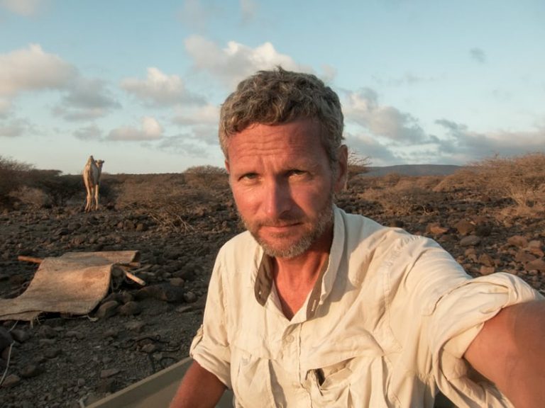
While Sala’s eyes focus on the world’s oceans and marine life, Paul Salopek keeps close watch on the land and its people.
Salopek founded and is leading the Out of Eden Walk, a National Geographic Society project to retrace the ancient path of global migration. Salopek is doing this by walking 21,000 miles from Ethiopia to the southern tip of South America, chronicling his journey along the way with articles in National Geographic and other publications and stories created using ArcGIS StoryMaps. He began the Out of Eden Walk in 2013 and is currently in China. He expects to finish the walk in about seven years.
In his Esri UC talk, A Walk through the Anthropocene, Salopek said he confronts sustainability issues all the time during his walk, from climate change to income inequality. “It’s concrete. It’s not abstract,” he said.
The impact of climate change was glaringly apparent when Salopek joined Afar pastoralists as they herded camel in Africa’s Rift Valley. “Fickle rains are getting more unpredictable. Pastureland is shriveling up. Water holes are drying out,” he said. “[The Afar people’s] entire way of being—this pastoral economy of moving animals across an unreliable landscape—is becoming increasingly untenable and pushing them into cities. A whole way of life is thinning out and vanishing.”
In India, Salopek said he witnessed the negative impact of the country’s Green Revolution that boosted crop production, in part by using fossil fuels to pump groundwater. Now the nation is plagued by water pollution and a lack of water.
“India is going through the most severe water crisis of any country in the world,” he said. “They are not just running out of water to drink but water to grow their foods and to stoke their industries. But now water quality is highly compromised by pesticides [and] by chemicals.”
Though the problem is overwhelming, local communities are responding to increase sustainability. “[People] were digging tens of thousands of small surface wells to capture rainfall,” Salopek said. “They were [planting] old crops that were better adapted to drought conditions to feed themselves.”
Salopek left the virtual audience words of wisdom about the importance of sharing resources, embracing openness, and seeking solutions. “We are an amazing problem-solving species,” he said. “We have lots of problems—most of them created by ourselves, and we have to resolve them. But our ancestors—the ones who walked across the earth back in the Pleistocene [Epoch] and those hunters and gatherers who I’m following from campfire to campfire—they problem solved their way across unknown landscapes. We’ve got to continue using those muscles.”
View Stories from the Out of Eden Walk, a collection of Salopek’s ArcGIS StoryMaps stories.
Expanding Racial Equity through Community Action
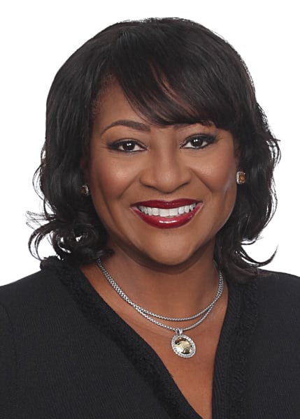
Promoting equity is part of the equation toward creating a sustainable future, according to Dangermond. He invited La June Montgomery Tabron, CEO of the W.K. Kellogg Foundation (WKKF), to talk about this topic to the global audience.
WKKF awards grants to support the health, welfare, and education of children; support families; and build equitable communities. The foundation, launched by Kellogg Company founder William Keith Kellogg in 1930, awarded $252 million in grants in the fiscal year that ended in August 2020. “[Kellogg] gave us, as a north star, [a mission to] create a place where all children can thrive,” Montgomery Tabron said. “To make sure that children thrive, you must look at issues of racial equity, community engagement, and leadership. We call those three elements our DNA. These are at the root of creating thriving communities where all children can have an opportunity.”
GIS technology can be used to better understand systems and structures that create racial inequity, according to Montgomery Tabron. “By mapping data on COVID-19, for example, you start to see, as we did, that people of color were having more complications as it related to COVID-19 and were even maybe dying more than others,” she said. “That allowed us to [ask], What are the systems that are producing these outcomes? And we learned that more people of color were essential workers who couldn’t stay inside their homes and quarantine. Therefore, they were exposed [to the disease] by greater measures.”
WKKF, its grantee the PVBLIC Foundation, Esri, and the United Nations have created a partnership called the SDG Data Alliance in support of the United Nations’ Sustainable Development Goals (SDGs), including No. 10: reduced inequalities.
“This alliance will enable 20 countries in Africa, Latin America, and the Caribbean to achieve the sustainable development goals,” Montgomery Tabron said, adding that many of these nations face practical and technological barriers to working on the goals. “The grant will build the information technology capacity and infrastructure to allow these countries to monitor and report their efforts toward achieving the goals.”
WKKF is partnering also with the Southern Communities Initiative to create an action plan to tackle issues related to equity in communities such as Atlanta, Georgia; Birmingham, Alabama; Memphis, Tennessee; Houston, Texas; New Orleans, Louisiana; and Charlotte, North Carolina. One aspect of the project is the creation of Community Action Hubs, where data and maps on wealth creation, jobs, education, health, and housing can be accessed to promote better informed decision-making by government officials, business leaders, and others.
“We hope the GIS community will help us realize this vision,” Montgomery Tabron said. “We have the tools. We want the GIS community to stand up these Community Action Hubs all over the nation.”
Watch Montgomery Tabron’s entire presentation on WKKF’s work toward building equitable communities. To see an example of a Community Action Hub, visit the New Orleans Community Action Hub.
A Collective Responsibility for the World’s Future
Dangermond praised the work of Crowfoot, Sala, Salopek, and Montgomery Tabron and their organizations for the leadership roles they are taking for creating a sustainable future. However, he again encouraged everyone to get involved.
“Our world is being challenged on many fronts, and we will increasingly need to be responsible for its future. Part of this presentation is about [raising] consciousness about it, even among ourselves,” Dangermond said. He encouraged audience members to move forward with purpose, doing things such as providing leadership; thinking holistically; promoting geographic thinking; applying new tools and methods; and collaborating and exchanging ideas with other organizations. “You and your work are going to be essential.”
The time to act is now, according to Dangermond. “These are the times we are going to have to get it together and move at many different scales,” he said.
