Technology Firm Uses Drones, along with Drone Mapping Software from Esri, to Model Steep Slopes in Jackson Hole, Wyoming, for an Inaugural Snowboarding Competition
The Natural Selection Tour, a snowboarding competition series sponsored by the energy drink company Red Bull, attracts many elite freestyle snowboarders, such as Mark McMorris and Zoi Sadowski-Synnott, to spectacular courses such as Jackson Hole Mountain Resort in Wyoming, Baldface Lodge in British Columbia, and Tordrillo Mountain Lodge in Alaska. Due to the challenging terrain and weather conditions in Jackson Hole, the first stop on last winter’s inaugural tour, Red Bull planned to give the snowboarders a tool they could use on their smartphones to visualize their route in advance of the event.
To create a 3D model of the terrain for this type of visualization experience, high-quality imagery needed to be captured and processed. This was done using drones and Site Scan for ArcGIS, end-to-end cloud-based drone mapping software for imagery collection, processing, and analysis.
Red Bull launched the project by hiring XR Media Group, an Emmy Award-winning production company. To best capture the competition trail—full of trees, cliffs, rocks, and jumps—XR Media Group asked VCTO Labs to step in and assist. VCTO Labs provides technical solutions to help organizations and television shows bring their stories to life. VCTO Labs chose to use drones to get the imagery at Jackson Hole and used drone mapping software, with specific features that had not been tested in the field, to capture high-quality imagery. The intention was to allow competitors to get a fully virtual experience before they hit the mountain.
The main objective of capturing drone imagery was to virtualize the ski area where the competition was to take place. Pete Kelsey, the owner of VCTO Labs, explained that Red Bull wanted the competitors to be able to see the trail in 3D in order to virtually plan their run on a smartphone. The Natural Selection tour is a 100 percent backcountry competition, meaning the course is set up with a selection of natural terrain, powder, trees, boulder fields, and natural and human-made jumps. As such, the VCTO Labs team also needed to map the different obstacles and jumps on the mountain.
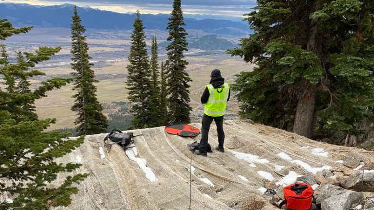
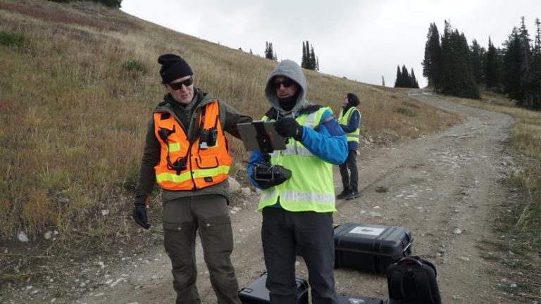
The rugged terrain made it difficult to fly drones and capture quality imagery. The terrain included a very high mountain elevation (9,000 feet above sea level), a steep average slope of 45 degrees, and 1,000 feet of elevation difference. The high elevation translated to thin air near the top, which Kelsey says can affect the aerodynamics and battery life of the drones they were flying. The area is also heavily wooded and lies on the northern and eastern borders of Grand Teton National Park, which doesn’t allow drones, so finding a way to legally fly was an additional obstacle.
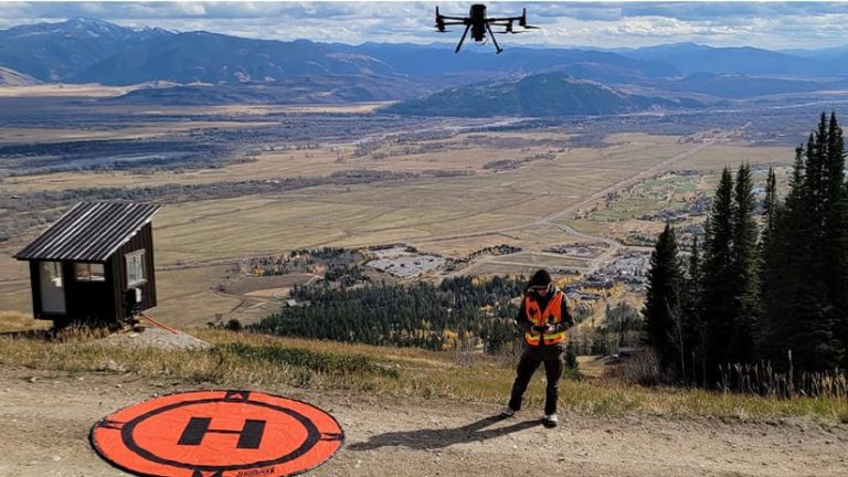
The ski area for the competition was also expansive. “The client had asked that we do an overall large area of just over 1,000 acres. And then [the client] asked that we then really concentrate all our technology on the competition area, which was around 16 acres,” Kelsey said.
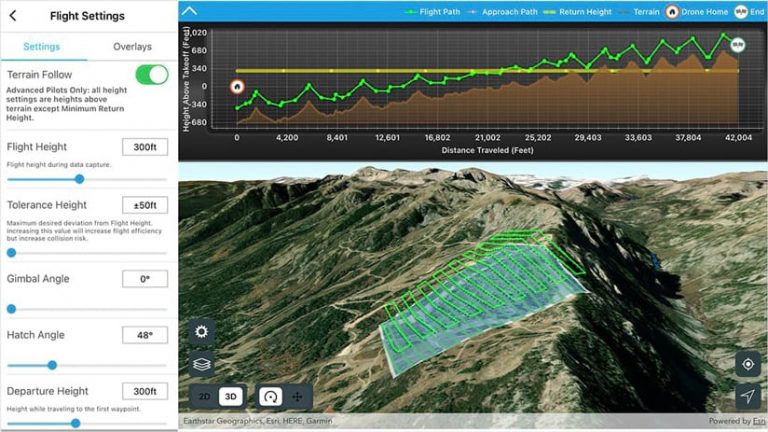
Terrain Follow Makes Its Debut
Kelsey first assembled a small team, which included Bobby Valentine, a Colorado-based technology evangelist with expertise in visualization and reality capture. Valentine said he previously had used different drone imagery capture techniques in the mining industry that were time-consuming. On a recent project at a Colorado granite mine site with an 800-foot vertical drop, he would repeatedly fly the drone in tiered rectangular area scans to maintain a consistent altitude.
“I had to fly using a tiered technique. It took a tremendous amount of time because you would have to plan these flights individually. You’d have to figure out what your elevation changes were,” Valentine said. “It was dangerous, and it took a lot of time to plan and a lot of batteries to fly.”
Kelsey and Valentine set out to find a solution that would enable them to capture quality imagery and maintain a consistent altitude.
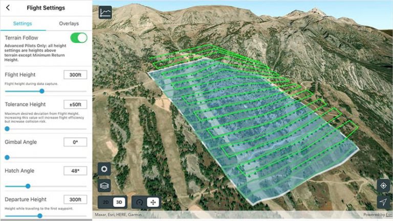
Valentine was very familiar with Site Scan for ArcGIS, having used it for the first time six years ago during a project at Colorado’s Red Rocks Park and Amphitheater. He recommended it for the Jackson Hole site survey. Site Scan for ArcGIS consists of two apps: Site Scan Flight for ArcGIS, a mobile app for planning and executing drone flights, and Site Scan Manager for ArcGIS, a web app for processing and visualizing drone imagery. Using Site Scan Flight, users can plan optimal flight paths. They can import data layers and 3D models from previous flights or ArcGIS Online, which enhances flight safety and planning accuracy.
Kelsey said newly released features in Site Scan Flight were mission critical, namely terrain follow. Not yet in beta at the time of the project but now fully supported, terrain follow allows a drone pilot to load 3D terrain data in the mission planning software. This enabled the drone to follow the ground and fly at a consistent height above the mountain in Jackson Hole. Mapping in this way creates a very detailed model of the slope, with constant image overlap and resolution throughout the flight, while maintaining a safe distance from the terrain.
Esri Steps in with Support
With no documentation available for terrain follow at the time of the project, Kelsey and Valentine received support from Nico Bonnafoux, product manager for Site Scan for ArcGIS at Esri, while imagery of the competition area was being captured. Kelsey and Valentine were the first to use the terrain follow capability for a commercial purpose in the field, and Bonnafoux was walking them through the new capabilities by phone while they were out on the mountain. Drone Tech Imaging, a Colorado-based technology firm, captured the drone imagery from the full 1,000 acres.
Valentine said he and Kelsey spent a lot of time planning the missions and trying to determine things like how high the drones would fly, how tall the trees were, and where to take off and land. However, the team knew that things could change on-site, and the steep grade along with wind, snow, and the rough physical terrain made completing the mission a challenge.
However, things went smoothly, thanks to terrain follow. “Without terrain following, the risk is you’re almost guaranteed to capture bad data or that the drone will collide with the ground and you’ll have a total loss,” Kelsey said. ” It was very tense and stressful, but it was a lot of fun figuring it out.”
Added Valentine, “If we hadn’t had access to [this feature] through Esri, the project wouldn’t have worked. Nobody had used this function within Site Scan before. It was the day it was released to beta,” he said. “It was a bit of a miracle that the planets aligned and Nico [said], ‘Hey, I’ve got something that you guys should try.’ ”
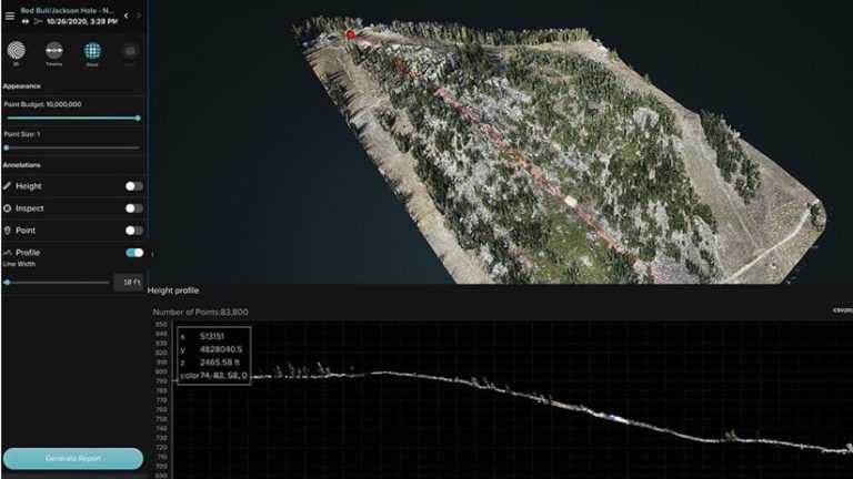
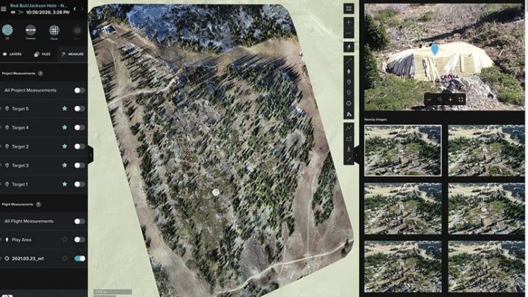
With the objective of getting a 3D point cloud and mesh model of the competition trail—including its obstacles, jumps, and landing areas—Kelsey and Valentine got the quality imagery they needed in a matter of hours, despite having to work in severe winter weather conditions. The terrain follow feature in Site Scan Flight streamlined the imagery collection process by eliminating the need for repeat flights. When Kelsey and Valentine had previously tried a different software, repeat flights were needed.
“This [feature] allowed us to fly patterns otherwise impossible until [we had the] the ability to follow terrain and capture the data we needed at a consistent altitude and fidelity. And, like I said, it was flawless,” said Valentine. “There were a lot of high-fives going on.”
The quality of the data collected also improved as a result of the terrain follow feature in Site Scan Flight for ArcGIS. Valentine explained that after he and Kelsey got guidance from Bonnafoux on how to set up the flights and what flight modes to use, the app took care of the rest and the data captured was excellent. Site Scan is designed to produce high-accuracy and high-resolution outputs safely and efficiently.
“If you’re doing these flights with tiers or you’re just flying higher to avoid the terrain, then you won’t get as good of results because your imagery resolution would be lower at the bottom of the site, and you may have insufficient overlap between images near the top,” Bonnafoux said. “This functionality [avoids] these workarounds that Bobby would have had to go through in the past, of flying in different tiers and doing all these multiple flights, which is extremely time-consuming.”
Due to the nearby national park’s no-fly zones, the geofence feature in Site Scan was another beneficial capability used at Jackson Hole. Enabling a geofence allowed the team to create a flight path that kept the drone within a defined polygon and within preselected boundaries, helping to avoid obstacles and stay outside the no-fly-zone.
The ability to download maps before a flight and view them offline also helped the team. Valentine says without this “must-have feature,” the team would have been unable to use the terrain follow functionality.
“We were in areas where there’s no cell service, so the ability to download the maps so [that] when we go in the field, we could bring that stuff up remotely, was hugely beneficial,” Valentine said. “[We could] download the maps so we had the 3D data to then plan our altitudes and the terrain following.”
Bonnafoux adds, “That was one of our challenges in developing this—making sure that this functionality is usable offline. In a lot of cases where you are flying in areas with a lot of elevation changes, it’s remote areas where you might not have a cellular connection. So being able to download that data locally is an important function.”
Kelsey and Valentine look forward to working with Bonnafoux and the Esri imagery and remote sensing team in the future, with both men saying that Esri’s support was critical to the success at Jackson Hole.
“[Terrain following] was new functionality that had never been used before in the field. So, Nico was supporting Bobby in the field in real time. That, to me, speaks really highly of Nico and the culture of Esri,” said Kelsey. “Nico always answered the phone. I mean, we’re on a mountain in a snowstorm, being taught how to use this functionality. He was just as important to the success of this thing as the tool itself.”
Once all the imagery was captured and the team members returned to a location with internet connectivity, they uploaded the imagery to the Site Scan Manager for ArcGIS cloud. There, it was processed into a 3D point cloud and mesh as well as a 2D orthomosaic high-definition map and elevation model. This process is fully automatic and enabled the team to complete processing in only a few hours, well before the team made it back to home base.
After the Natural Tour selection project was completed, Kelsey says the 3D model of the Jackson Hole ski area received excellent feedback from XR and Red Bull with the development of this new workflow. He acknowledges the risk of using beta software in the field and says it was a leap of faith but is happy the team was “positively reinforced.”
Kelsey adds that Esri’s leaning into the digital twin (a virtual model of a real-world place) and reality capture is significant because so much of data captured is spatial.
“The beauty of a digital twin is that the data can be repurposed for anything. You’re literally only limited by your imagination,” Kelsey said.