
The City of Key West, Florida, Contributes Updated Address Point Data to the ArcGIS World Geocoding Service, Providing More Accurate Information for Everyone
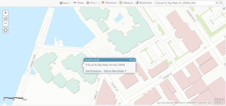
The city of Key West, located at the southern tip of the Florida Keys, is famous for its snorkeling and diving spots, key lime pie, relaxed lifestyle, and pastel-hued conch houses. The community of approximately 25,000 full-time residents features many resorts, mobile home parks, and condominium complexes. It’s also one of the few American communities to have any addresses that start with a 0, the most famous here being 0 Duval Street, home to the Ocean Key Resort & Spa.
However, users of the ArcGIS World Geocoding Service could not find 0 Duval Street, mobile home park lot numbers, and some other address points in the city until they were added by the city in late 2021. The City of Key West contributed its latest internal data—approximately 14,000 addresses—to the service.
Now, people can use the ArcGIS World Geocoding Service to search for and find addresses within the city of Key West that include apartment numbers, unit numbers for condominium complexes, and lot numbers in mobile home parks. Many new addresses in Key West were added to the geocoding service. The addresses are clearly displayed on rooftops rather than along the roadway edges on the map, making them easier to distinguish.
“This is a massive improvement for anyone searching for or geocoding addresses within our community,” said Scott Fraser, the Federal Emergency Management Agency (FEMA)/Community Rating System (CRS) coordinator and floodplain administrator for the City of Key West.
Fraser said he volunteered to update Key West’s address point data for the ArcGIS World Geocoding Service, spending nights and weekends for five months in 2021 to complete the project. He’s unsure of the source of the original address point data. “Wherever it came from, it was pretty old,” he said. “If I see something is broken, I try to fix it.”

He took a new set of address data points created by Matt Willman, the city’s GIS administrator; converted them to the Next Generation 911 (NG-911) data schema; and then exported that data into the schema for Esri’s Community Addresses using a conversion tool that Esri provides. Esri’s Community Addresses, part of the Community Maps Program, collects address point data for the ArcGIS World Geocoding Service.
“Since the data needed conversion, it seemed best to follow the NG-911 format ,which would someday be needed anyway,” Fraser said. “The city has the technical capability to implement NG-911, but it’s my understanding the statewide infrastructure isn’t yet available to accommodate it. But that day will come. It made sense to translate our current addressing data into a NG-911 format so it would serve the dual purpose of improving Esri’s geocoder and bringing the city much closer to being NG-911 ready,” Fraser said.
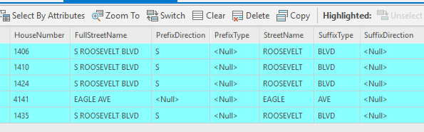
Parts of the job were tricky. The old data had each complete address in a single field, whereas modern-day data requirements break down every facet of an address into separate fields. The address1406 S Roosevelt Blvd, for example, needed to be converted into [1406] [S] [Roosevelt] [Blvd]. “Plus the format used in Key West also needs to match its counterparts in other cities for NG-911 to work properly. Free online seminars from DATAMARK about NG-911 addressing concerns helped a lot,” Fraser said. DATAMARK, an Esri partner, is the public safety GIS team for Michael Baker International, an engineering and consulting services firm based in Pittsburgh, Pennsylvania. The team works with public safety agencies on GIS strategy and planning, training, transition to NG-911, and other services.
Fraser said he discovered issues with some of the address point data in the World Geocoding Service while working on a geocoding project that was not related to his work for the city. He discovered that some street segments had been reversed, meaning that house numbers that should have been close to the end of the street were near the front of the street. He also found that each mobile home park only had its street address listed rather than each individual address with the street and lot number, and that the few addresses that started with a 0—which came into being early in the city’s history—were nowhere to be found.
Fraser collaborated with Esri Geocoding Content team to finish up the process of converting the address point data to the schema required for Community Addresses contributions. This included getting an exception made for the four addresses that start with a 0. “Usually, a geocoder wants to see 0 as an address [that’s] missing a street number integer,” he said. “That complicated matters.”
Now, people can find 0 Duval Street, 0 Go Lane, 0 Simonton Street, and 0 Sunset Key Drive, whether they use ArcGIS Online or a new city address locator.
This also has enabled the City of Key West to generate a local address point locator that’s quite handy. When using the city locator, users can type the word “lot” after the street name, and that exposes the lot number options in a drop-down list.
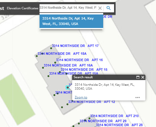
Many building complexes that share a main address have one point for the entire complex, accompanied by individual building identifiers. In this example, the “Northside Dr” building identifiers aren’t used. Instead, the apartments are numbered consecutively.
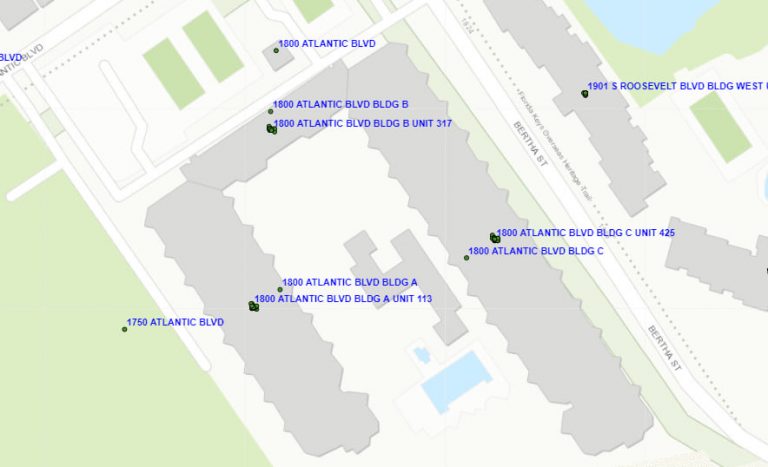
For “1800 Atlantic Blvd,” there is one point for the entire complex as well as separate points for each building and the unit identifiers.
Fraser said that the City of Key West’s updated address point data in the ArcGIS World Geocoding Service will be useful in a variety of scenarios, whether it’s for a utility that wants to create a detailed map or for a political candidate geocoding addresses for a campaign. “And anyone looking up an address will have more accurate information,” he said.
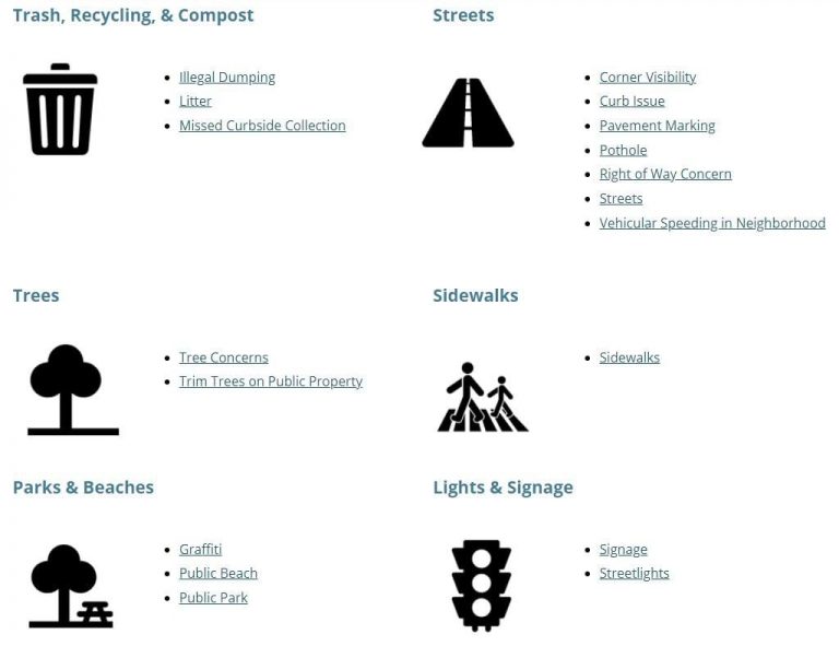
Updating the address point data for the City of Key West will better serve residents and visitors too. The city’s Key West Connect app helps residents reach the city online, via smartphone or tablet, to request services or report issues such as litter, illegal dumping, missed curbside trash collection, and potholes.

This app currently provides the new and updated addresses via Android devices and personal computers (PCs), ensuring that community service request locations are even more accurate.
Fang-Hsu Lin, senior product engineer on the Esri geocoding content team and curator for Esri’s Community Addresses, encourages more communities to participate.
Contributions like the one by the City of Key West can be made by creating an account through the Community Maps Program.
The Community Maps Program works with authoritative data providers all over the world in an effort to develop a suite of authoritative maps for use globally by the public in a wide variety of applications.
This includes the best available address datasets to support the ArcGIS World Geocoding Service.
“To date, address data contributors have added over 16 million unique address points through this effort,” Lin said. “The quality of any geocoding technology highly depends on the address data from which it is built. With your help, we can make our reference data even better.”
To learn more about Esri’s Community Addresses, read this ArcGIS Blog post authored by Lin. This ArcGIS StoryMaps story, Esri’s Community Addresses, also provides more details.