Mountain ecosystems tend to be fragile and easily damaged by natural and human-caused factors, from landslides and flooding to climate change and timber extraction. Yet they are important for a few reasons, including biodiversity. Since they also provide valuable ecosystem services such as water flow to lower altitude areas, they can be particularly important in areas where hunger and food security are issues.
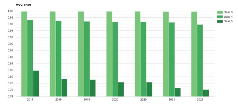
To help efforts to preserve these environments, the Food and Agriculture Organization (FAO) of the United Nations developed the Mountain Green Cover Index (MGCI). Its methodology uses GIS and standardized time series land cover maps to measure changes in vegetation—including forests, cropland, grassland, and wetlands—for mountainous regions.
By monitoring these changes, countries can evaluate and prioritize conservation efforts such as reforestation and cleanup campaigns.
Not only does FAO lead international efforts to eliminate hunger and improve nutrition and food security, but it also seeks to address the Sustainable Development Goals (SDGs) set out in the United Nations (UN) 2030 Agenda for Sustainable Development Goals, including SDG 15—to protect, restore, and promote sustainable use of terrestrial ecosystems; sustainably manage forests; and combat desertification.

Developed with ArcGIS Pro, the MGCI was designed as an indicator to monitor progress toward SDG 15, including in mountainous areas such as the Kingdom of Lesotho in southern Africa, which has used the MGCI in its efforts to conserve the Orange-Senqu River Basin.
A GIS-Based Methodology
FAO produced initial baseline estimates for the MGCI in 2017 by visually interpretating land cover types at sample locations that were superimposed on satellite imagery. However, with this approach, it was difficult to evaluate the accuracy of the estimates, and countries could have only limited involvement in estimating the MGCI.
By 2020, FAO had overhauled its process, establishing a method of data collection that prioritized quantitative analysis.
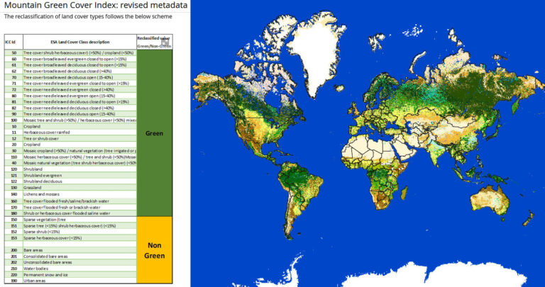
“FAO developed a methodology to compute the MGCI which applies spatial analysis to standardized land cover data and a global digital elevation model,” said Dr. Lorenzo De Simone, geospatial officer at FAO. “It automatically extracts mountain green cover areas directly from the standardized time series land cover maps.”
The land cover data is used to quantify green and non-green areas, while the digital elevation model defines elevation ranges. For each elevation range, the ratio between the amount of vegetation to the total area is computed, yielding the final value of the MGCI. A value of 100, for instance, means that the entire area is covered with vegetation.

This process eliminates the need for time-consuming visual interpretation of earth observation data—but also means that the accuracy of the MGCI depends on the accuracy of the land cover maps used.
FAO used global land cover maps developed by the European Space Agency (ESA), specifically the ESA Climate Change Initiative (CCI) time series land cover map, to compute the MGCI globally, at a national level, and for different elevations. ArcGIS Pro’s ModelBuilder, a visual programming language for building geoprocessing workflows, came in handy to automate various geoprocessing tasks and standardize outputs.
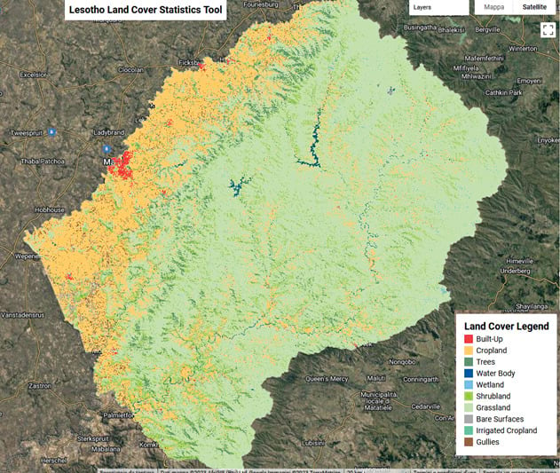
“We tested the accuracy of our green and non-green land cover classifications from the ESA CCI map with data collected in Lesotho,” Dr. De Simone said.
The comparison indicated that the two sources of land cover data were in agreement, meaning that users of the MGCI could have a high degree of confidence in its accuracy, whether national or global datasets are used—though national datasets ensure the highest resolution and overall accuracy.
Improved Land Cover Mapping in Southern Africa
One place the MGCI has proved particularly useful is the Kingdom of Lesotho, a landlocked, high-altitude country encircled by the country of South Africa. Lesotho faces challenges related to excessive soil erosion caused by water runoff, with an estimated 4,500 tons of the country’s fertile topsoil lost every hour, according to ReNOKA (meaning “we are a river”), Lesotho’s national program for conserving the country’s natural resources. Other issues that contribute to declining food security include unsustainable farming practices and overgrazing—not to mention climate change, socioeconomic challenges, and a lack of natural resource data.
Lesotho’s mountainous landscape is uniquely suited to act as a collecting basin for rain and snow, a vital benefit for the surrounding region. “In fact, Lesotho is capable of harvesting so much water, that four countries benefit from the many rivers and tributaries that originate in the Lesotho Highlands,” notes the ReNOKA project website, referring to the neighboring countries of South Africa, Botswana, and Namibia. “As Lesotho’s wetlands become increasingly degraded, the very source of the Orange-Senqu River is under threat.”

The ReNOKA project, which received funding from the European Union and the German Federal Ministry for Economic Development and Cooperation, is dedicated to conserving the entire Orange-Senqu River Basin, an area of about 386 thousand square miles, or one million square kilometers. The project has used the MGCI to monitor changes in its wetland vegetation to improve catchment management efforts.
“The project has led to the development of a national system for the production of national land cover maps that automatically computes the MGCI using the national data as opposed to the global data,” said Dr. De Simone. “[This] increases the accuracy of results and ensures country ownership of the method.”
The methodology, which can be easily adapted for use by other countries, can benefit any place that seeks to conserve or increase green spaces in mountainous areas. Around the world, the MGCI helps facilitate the work of national agencies that monitor ground cover data by reducing reliance on traditional field surveys or visually interpretating satellite imagery, providing a foundation for building a greener world.
