
Hurricane Ian hit the Florida coastline in September 2022, devastating communities and ultimately causing more than $17 billion in damage across multiple counties. The city of Sarasota was no exception, with downed trees impeding emergency responders in the immediate aftermath of the storm. The Sarasota Parks and Recreation Department alone had to address over 300 individual emergency response-related work orders.
Fortunately, beginning in 2019, the city had begun laying the foundation for a system of work order processing through ArcGIS Workforce—a mobile app designed to coordinate fieldwork—that would prove critical in the response to Hurricane Ian.
“We were able to take the city map and divide it up into zones for our crew leaders,” said John Kretzer, landscape operations manager for the Sarasota Parks and Recreation Department. “We do the first push of cleanup after the storm, so we go clear the roads to make sure that they’re passable for emergency vehicles. The emergency operations center started taking calls about where trees were down blocking roads, and we were able to go in and assign those to specific crew leaders based on the map, with a separate layer for associated work orders.”
Even after the initial storm response was over, the benefits of managing assets with ArcGIS Workforce became clear, explained Larry Favor, supervisor for the Sarasota Parks and Recreation Department.
“As we repair, replace, or add new things to the facilities that we own, we all get them loaded into our GIS database that shows where they are, what condition they were in when they were installed, and what the expected life span is,” he said. “When a storm comes through, we have a record of what we lost.”
While the response to Hurricane Ian may be the most dramatic demonstration of the ArcGIS Workforce app’s benefit to the city, it has addressed the needs of multiple departments before and after the storm by establishing a streamlined system of communication and recordkeeping in public works, parks and recreation, and elsewhere.
“The amount of staff time saved is significant,” said William Rockwell, GIS coordinator for the City of Sarasota. “I conservatively estimate that we save more than 8,000 hours annually using Workforce.”
With its ability to be integrated with other ArcGIS software like ArcGIS Dashboards, ArcGIS Survey123, and ArcGIS Experience Builder—which the city uses to create landing pages for dispatchers and managers—the adoption of ArcGIS Workforce has been transformative for the City of Sarasota.
The Spread of Efficiency
Although Sarasota—a growing city that currently houses more than 56,000 full-time residents and an additional 2.3 million additional vacationers—began its transition to an ArcGIS Online cloud-based system for work order processing in 2019, the COVID-19 lockdowns accelerated the project.
“The increasing demand for services put a strain on our traditional work order management process,” said Rockwell. “Previously when a request came in, it was written down or an email was printed out and handed to someone to complete—no data, no analytics.”
“Almost everything we do is via work order,” added Kretzer. “We track everything that gets done, and we have a lot of public work orders that come in, so not having a way to do this efficiently wasn’t working.”
Even before the pandemic, it was essential that field crews be able to complete their tasks remotely, noted Kretzer.
“One of my goals was to have my staff all be online,” he said. “If a work order came in, we could distribute it right away, and they would be able to acknowledge the fact that they got a work order.”
Since then, ArcGIS Workforce has become central to Sarasota’s entire internal and public service request management process.
“It was an obvious choice to go with Workforce,” said Rockwell. “It’s mobile friendly, provides easy integration with other [ArcGIS software], and you can use dashboards to show data in real time—these are literally game changers for us. I showed city managers all the things Workforce could do, and they were impressed with its functionality and the fact that it was part of our existing ELA.”
The integration with other ArcGIS software in particular has come in handy in addressing many of the city’s needs.
“One of the big things that we were able to do is to utilize a combination of [GIS] software to come up with something that functions like asset management,” said Kretzer. “We go into the parks, and we identify each asset, take a picture of it, assign it the number, [and] give it a location. We do all the things that you would do for asset management, and any time we have a work order, we can reference that particular thing in ArcGIS Workforce.”
ArcGIS Survey123, for instance, is used to collect field data and create on-the-fly assignments. It also allowed the city to transition from paper time sheets to digital recordkeeping and provides the capability to capture the costs of labor, equipment, and materials. Moreover, cost analytics can now be displayed on dashboards created with ArcGIS Dashboards.
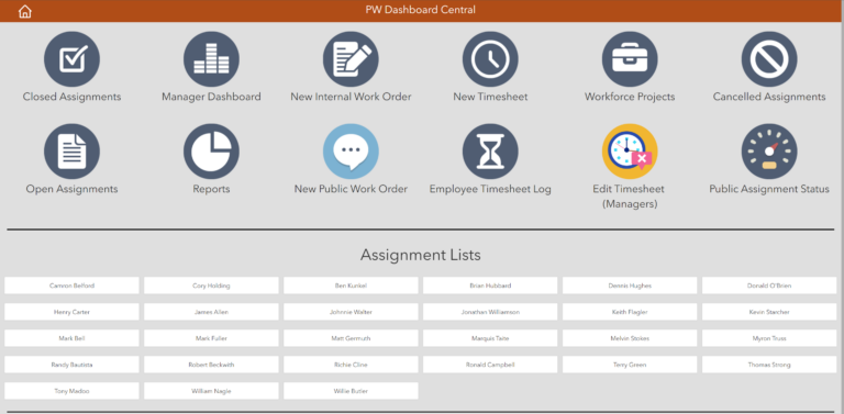
“Dashboards are the way in which managers keep their finger on the pulse of thousands of work orders being created and closed every year,” says Rockwell. “During the first two years of our ArcGIS Online workflow, there were 23,776 Workforce assignments created across 6 Workforce projects. Our current Workforce deployment uses 67 dashboards.”
Better for the City and the Public
The primary institutional challenge in implementing the system was getting field staff to understand the importance of changing how their work assignments were documented—moving from written notes and work orders to using a smartphone with apps.
“Once I was able to show field staff how the use of Workforce—and smartphones in general—was going to help them in their jobs, as well as their day-to-day lives, it was amazing to see them go from reluctant to enthusiastic,” said Rockwell.
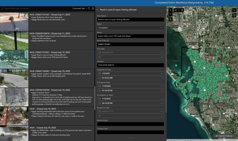
Moreover, Sarasota’s public-facing Workforce implementation allows residents to submit requests for services and receive email confirmations and ticket closure emails in response. The satisfaction survey distributed by the city indicates members of the public are very happy with their new method of communicating with Sarasota’s local government.
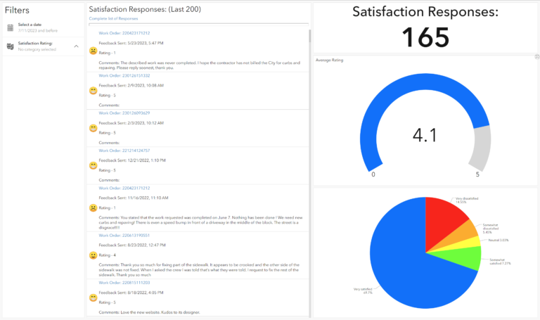
“The analytics provided via dashboards or the more in-depth option using SQL provides accurate and timely metrics that previously had to be gleaned by looking through reams of paper,” said Rockwell.” In addition, we’ve expanded our services, allowing our residents to submit requests with full closed loop communications that allow the city to be more responsive to [resident] needs.”
The Parks and Recreation Department first implemented ArcGIS Workforce in 2019. Its spread has been organic and transformative for the city’s municipal staff, ultimately supporting workflows for a variety of field activities and allowing mobile workers to easily manage their assignments.
“It was so successful [for the Parks and Recreation Department] that six other departments in the city, including Public Utilities and the Police Department, are now using it,” said Rockwell. “It’s touched almost every public-interfacing service we provide.”