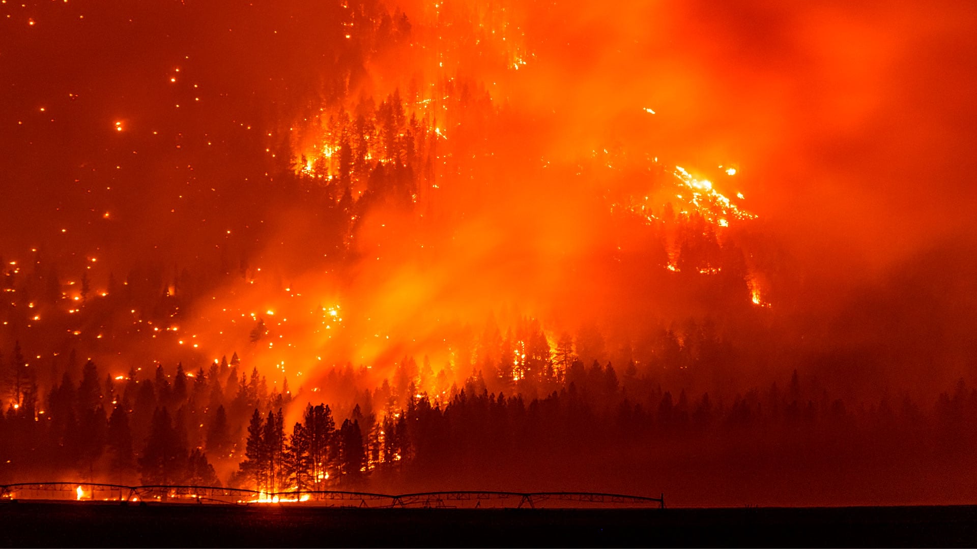
More than 6.5 million acres in the United States burned during 2021, with much of the destruction fueled by the dangerous combination of wildfire and wind. Wind often changes direction, intensity, and speed throughout the day, which can contribute to a wildfire’s spread and sometimes cost firefighters their lives.
That’s why it’s critical that firefighters on scene understand sudden shifts in the wind, wind speed, the effect of terrain on wind, and other factors. With that in mind, the Rocky Mountain Research Station’s Missoula Fire Sciences Lab, a Montana-based division of the United States Department of Agriculture (USDA) Forest Service, collaborated with the firm Technosylva to create a mobile version of WindNinja, a high-resolution wind model that the lab first created as a desktop application in 2007.
WindNinja Mobile, which can be downloaded for free from app marketplaces such as the Apple App Store and Google Play, was mainly created for firefighters with mobile devices or tablets who need to quickly compute and visualize wind direction and speed simulations.
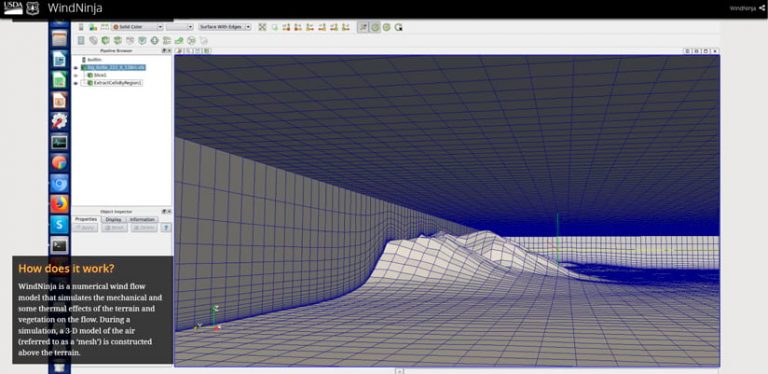
The Missoula Fire Sciences Lab researches, develops, and improves wildland fire management tools that agencies use to plan for, mitigate, fight, and recover from wildfires in the United States and abroad. One of its most popular tools is the desktop WindNinja application, which provides a wind forecast for mountainous terrains. The application has routinely been used by fire behavior analysts to gain situational awareness during a wildfire, drive fire spread models, or re-create a specific event during fire investigations. However, Natalie Wagenbrenner, a research meteorologist with the Forest Service, said it quickly became evident that a mobile application would be useful because fire personnel often work in disconnected environments without convenient access to desktop or laptop computers.
“As time went on, we realized that there are a lot of firefighters that don’t have access to WindNinja or WindNinja outputs because they are in the field, and they don’t have convenient access to laptops. But everybody is carrying around a cell phone, so we decided to create this mobile interface,” said Wagenbrenner.
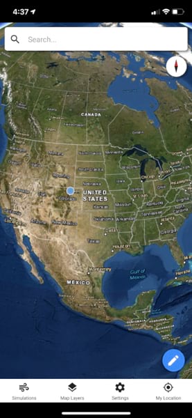
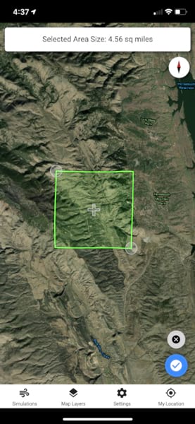
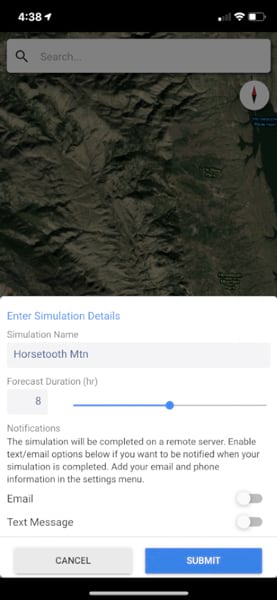
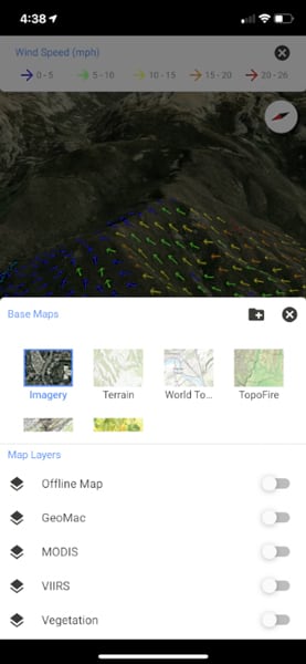
The latest version of the WindNinja mobile app was developed using ArcGIS AppStudio from Esri and provides high-resolution, near-surface wind forecasts that include wind speeds and directions displayed on a map. The user selects an area of interest that’s 50 square kilometers or less on the map, names the simulation, chooses a forecast duration of up to 15 hours in advance, selects whether to receive an email or SMS notification when the simulation is ready to view, and then submits the request. The user can also select from a variety of basemaps and turn on layers—such as vegetation and atmospheric, oceanic, and land surface imagery—collected, for example, by the Visible Infrared Imaging Radiometer Suite (VIIRS) instrument on a National Oceanic and Atmospheric Administration (NOAA) satellite.
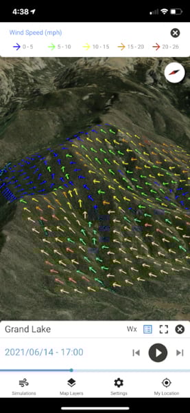
Connectivity is needed to run the simulation, which uses the High-Resolution Rapid Refresh (HRRR) atmospheric model from NOAA to produce the wind predictions. However, the results can be viewed offline in the field if necessary and then shared with others. The arrows on the map show both the direction of the wind and the wind speed. Wind vectors are displayed in the app colored by wind speed, with blue and green vectors representing lighter winds and orange and red vectors representing higher winds. The app was mainly created for firefighters with mobile devices or tablets who need to quickly compute and visualize wind direction and speed simulations. These simulations provide them with situational awareness, help keep them safe, and conduct work such as burnout operations, Wagenbrenner said.
Revamping an Earlier Version of the WindNinja Mobile App
To improve the interface and usability of an earlier version of the WindNinja mobile app, the lab enlisted the help of Technosylva, a company that provides GIS-based solutions for wildland fire protection planning, analysis, and modeling.
The Missoula Fire Sciences Lab had collaborated with Technosylva on previous projects and knew the firm was familiar with the WindNinja app. A few of the requirements Wagenbrenner requested for the new app included the ability to view outputs without connectivity (no cell phone coverage); a clean, simple interface; and a 3D viewer ideal for displaying the outputs.
Forest Service research and development scientists created the initial mobile version of WindNinja, but according to Joaquin Ramírez, Technosylva founder and principal consultant, it was based on software that had certain limitations. For example, Ramírez says models that predict the wind provide data every 1.5–2 miles, but in an area like California, the terrain may change dramatically in shorter distances. This can significantly impact wind behavior, and because of that, wildland fire behavior can change too.
Wagenbrenner said that she wanted the mobile app to be a simplified version of the desktop application, which offers more customization by the user in terms of model inputs, outputs, and simulation settings.
Ramírez agreed and wanted to redesign the app to provide complex modeling in an easy-to-understand way. “As technologists, our role is to…put [science] in the hands of the users,” he said.
Ramírez chose ArcGIS AppStudio to develop the new app for several reasons. ArcGIS AppStudio is designed to build cross-platform native apps from a single code base. The Technosylva team members have extensive experience using AppStudio, and after determining that a 3D environment would be needed to view wind and terrain activity over time, they knew AppStudio would be an ideal fit for the project.
“It’s a very 3D mapcentric application,” Ramírez noted.
In addition, the ability to deploy apps created with AppStudio across multiple platforms was a “big selling point,” says Andrew Buckley, a user interface/user experience designer for Technosylva. Buckley explained that being able to design a universal component would make app design and development easier, allow for faster delivery, and provide consistency for users when switching between devices.
“The ability to both design and build that same component that works on cross platform was fantastic. From a design perspective, AppStudio was great . . . because it really allowed for easy and quick design, knowing that I only had to make a component once and not have to redesign it completely for another platform,” Buckley said.
Buckley says that since AppStudio is composed of Esri technology on the back end, the team didn’t have to come up with certain custom components or tools from a mapping perspective because they were already there and easy to use.
“It wasn’t something we had to redo. It was standard stuff we could expand upon, rather than trying to go from the ground up,” explained Buckley. “ArcGIS AppStudio makes the design process quick and easy because I’m not having to redesign elements or keep changing them depending on the device or the operating system. I design a component once, and my team can easily re-create it for multiple platforms.”
App Integrates with ArcGIS
WindNinja Mobile is fully integrated with ArcGIS technology, which makes it easy to seamlessly incorporate mapping tools such as basemaps. This lets users choose the basemap (e.g., aerial imagery, fuel model, and United States topographic or world topographic), that would best fit the scenario.
To begin the development of the app, the Technosylva team discussed the technical requirements with Wagenbrenner because those needs would dictate the look of the interface and user experience. The team created wireframes for Wagenbrenner’s team to review, which helped perfect the workflows. Buckley said the Missoula Fire Sciences Lab staff wanted a simple way for the user to access information and create simulations without having to get into what he calls the “complex stuff.”
“We wanted something that was very mapcentric, and not only mapcentric from the side of viewing the outputs but actually generating and identifying the location where you wanted to do the simulation,” says Buckley.
The revamped WindNinja Mobile app calculates the effects of the wind on the terrain, and users can choose to receive an email or text message notification when their calculations are complete. Users can download and view the simulation in the mobile app when complete. The app also allows users to visualize VIIRS hot spots (hot spots derived from the NOAA satellite that represent locations with possible fires), change the view to a topographic map, and add their own local TPK maps.
According to Wagenbrenner, the WindNinja Mobile app is growing in popularity—downloads now top 4,700, and new subscribers are being added daily. The app is now in the hands of more on-the-ground firefighters, and the new interface is much cleaner with a simpler workflow, ultimately improving the user experience.
“WindNinja Mobile is designed specifically to allow users in the field that don’t have access to laptops to be able to—just with a [tap] of a few buttons—get some better estimate of what the winds are doing in the areas where [users are] working to improve safety and situational awareness,” said Wagenbrenner.
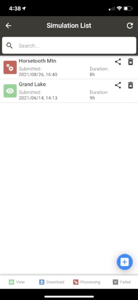
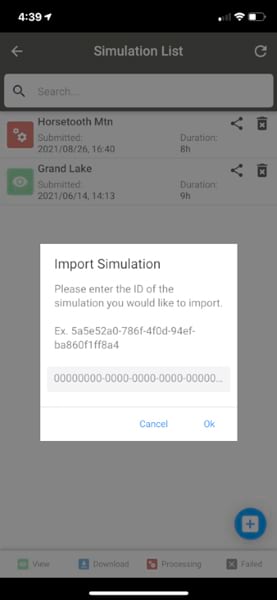
The updated mobile app has introduced a streamlined workflow: users tap a button to create a simulation, digitize on the map where they want the simulation to be, set the simulation duration, and tap Run. Users can also access previously run simulations with the tap of a button. In the desktop WindNinja application, there are a lot more customization options available. That works well for users who may have more training or experience in weather or fire behavior, according to Wagenbrenner.
However, for fire personnel on the ground who have limited knowledge in this area or don’t have a lot of time to set up a simulation, Wagenbrenner said that the simplified interface works “because we make a lot of choices for the user ahead of time.”
“On WindNinja desktop, it’s a lot more complex, and there are a lot more fields. So one of the tasks was to streamline the process,” Buckley said. “Especially out in the field, a firefighter doesn’t have a lot of time. So in just a few very quick short clicks or taps on the screen, you can have a simulation run.”
WindNinja Mobile allows users to share their completed simulations by sending a link. The recipient can download it to WindNinja Mobile and access it even when disconnected. The ability to run and view simulations with limited or no cell coverage is one of the most significant benefits of the mobile app.
For example, Wagenbrenner says firefighters can run a simulation in the morning at fire camp when they do have coverage, download the simulations to their device, and have them available when they’re ready to go out for the day. “It’s a really good setup to be able to have that offline capability for viewing those outputs,” she said.
The feedback Wagenbrenner has received about WindNinja Mobile has been very positive, with an array of users sending in reports and photos detailing how they have used the app in the field and how it was helpful for their work. She adds that users like the mobile app because it’s easy to use and the modeling is accurate in many cases.
She notes, “Users have reported that the winds that they’re seeing predicted in the app are what they’re seeing on the ground . . . so I think we’re just going to see more and more use.”
While the target audience for WindNinja Mobile is wildland firefighters, Ramírez says that the capability of accessing a high-resolution wind model has applications in different activities such as avalanche forecasting, or sports like paragliding and backcountry skiing. The Technosylva team is excited about the possibilities and looks forward to continuing its work on projects that can help firefighters.
“Learning and helping to make the science actionable—that’s something that puts a smile on your face. That’s one of the wonderful projects that you want to be involved in,” said Ramírez. “For us, it’s been amazing to work with [Missoula Fire Sciences Lab]. We really feel very happy to serve this community together.”