
Coordinating student safety on a university campus is a crucial and complex endeavor that necessitates managing a large amount of data about personnel and safety infrastructure across a huge area.
Luckily, the University of Rhode Island (URI)’s Office of Spatial Services has collaborated with the university’s public safety department to take advantage of GIS resources in transitioning its siloed, spreadsheet-based data to a more usable and accessible GIS-based system of data management. Public safety datasets previously maintained separately in spreadsheets are now maintained in ArcGIS Enterprise, including data about emergency blue light phones, exterior security cameras, automatic external defibrillators (AEDs), and parking space inventory.
The transition from spreadsheet to GIS required an initial lift: importing the tabular data into the geodatabase. The tabular data still exists, but it is now easier to visualize and access in a GIS-based format. Public safety staff quickly saw the advantage of the ability to overlay previously isolated datasets, edit location and attribute information, and make informed decisions based on compiled data.
“The GIS tools we’ve developed for public safety at URI help us bring together disparate data sources to evaluate our safety and security infrastructure in a holistic manner not previously possible,” said Sam Adams, URI Assistant Director of Public Safety.
GIS Tools in the Office and the Field
One of the tools Adams and the rest of the public safety staff have taken advantage of is ArcGIS Experience Builder. It was used to create a data editing application hosted on URI’s ArcGIS Enterprise portal. With this app, public safety staff don’t need to be trained in GIS to edit their GIS data. They use the edit widget to perform basic editing tasks: marking a security camera as out of service, creating a feature for a newly installed blue light phone, or moving an existing AED to a different location.
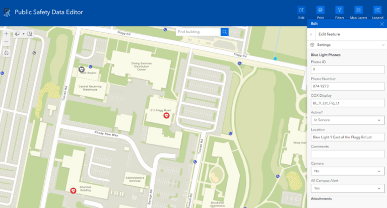
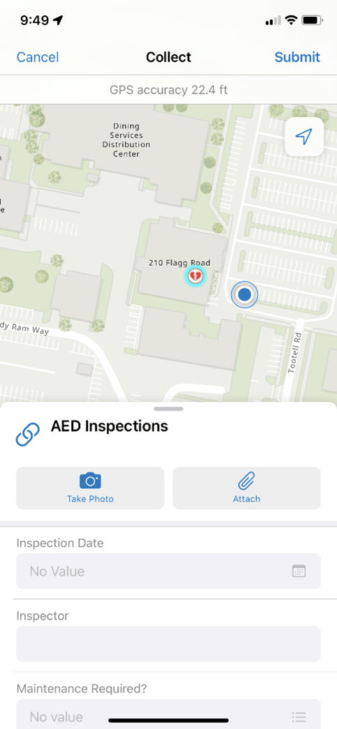
When not at their desks, public safety staff can access their GIS data using ArcGIS Field Maps on their mobile devices. Staff use ArcGIS Field Maps to inventory and inspect their automatic external defibrillators (AEDs), the red and white boxes seen on walls in public spaces. Inspection records are not spatial features, and do not appear as points on the map, but are maintained in a related table linked to the AED feature layer. Every AED has a global ID, a string of numbers and letters unique to a single feature. When the data collector selects an AED to inspect, that AED’s global ID is automatically recoded in the inspection table, linking the inspection to the device, and maintaining past inspections in the database.
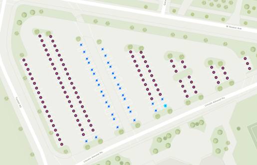
While AEDs, emergency phones, and security cameras are valuable public safety assets, there is no hotter commodity on a college campus than parking. The parking space inventory at URI is maintained in ArcGIS Enterprise and can be edited with ArcGIS Experience Builder and ArcGIS Field Maps.Parking spaces are symbolized as point features , colorized by use restriction—Americans with Disabilities Act (ADA), motorcycle, electric vehicle, or service vehicle—and further classified by user—commuter student, resident student, faculty/staff, visitor, or multiuse.
Transportation and parking staff use this data to decide how many and what kinds of parking permits to sell and inform the public of ADA parking accommodations. URI contributes data to Esri’s Community Maps program, so the ADA spots featured in the database are also incorporated into ADA spots on Esri’s publicly available basemaps. The parking data also serves the planning and real estate staff at the university to answer questions such as how many parking spots will be lost if the university constructs a new residence hall in a specific location.
Security on the Horizon
Some public safety data, like ADA parking spaces, is meant to be shared with the entire university community. However, the locations of other public safety assets are sensitive. For this reason, URI hosts its public safety data on its Enterprise portal. In contrast to ArcGIS Online, in which data is hosted on Esri servers, Enterprise data is hosted on URI-owned servers. Additionally, the portal interface allows GIS data managers to select who in our organization should have access to what data through groups. For example, the “Parking Services” group only includes portal members who need editing access to the parking inventory.
GIS Champions at URI are always thinking of new ways to improve public safety with GIS technology. Next, the public safety department aims to deploy ArcGIS GeoEvent Server, which will incorporate live data feeds into their maps. The goal is to create a map of parking lots that turn from red to green as parking spaces become available, with data transmitted in real time by sensors at the entrances of the lots.
Staff are also in the process of implementing ArcGIS Indoors across campus, which opens new doors to asset mapping within a building and would not have been possible with a system of spreadsheet-bound data.
“The ability to view ‘flat’ data spatially allows us to gain new insights to better protect our campus community and improve quality of life for our students, faculty, staff, and visitors,” said Adams.