As with the management of any natural resource, effective water management starts with data collection. Accurate and widespread real-time measurements of streamflow data, for instance, can enable agencies like the Montana Department of Natural Resources and Conservation (DNRC) to meet water demands and plan for climate variability.
The DNRC is the government agency responsible for ensuring the sustainable development of Montana’s land, minerals, natural gas, oil, timber, water, and other resources. In 2015, the agency adopted the Montana State Water Plan to support the management, administration, and beneficial use of Montana’s water resources—a plan that includes providing high-quality hydrologic data. Specifically, it identified the need for Montana to develop a network of real-time streamgages—instruments that measure and record the amount of water flowing in the river or stream or its discharge—on streams and tributaries that are not part of the United States Geological Survey (USGS) monitoring network.
To achieve this goal, the DNRC uses AQUARIUS analytics software to collect streamflow data. AQUARIUS software is designed to acquire, process, model, and publish water information in real time. However, what the DNRC needed was a GIS-based solution that would provide detailed streamflow data and information on a publicly accessible website, which did not exist before 2020. A web application meeting these criteria needed to enable the DNRC to collect, analyze, and present accurate, high-quality, and real-time data for critical surface water locations. The prospective app’s goals included supporting local and regional water resource management, distribution, and allocation. Additionally, it had to account for the installation and maintenance of up to 100 permanent real-time streamgages by 2025.
In 2020, the DNRC turned to Geographic Communication Systems Holdings, Inc. (GCS), a geospatial IT services company based in Missoula, to develop a publicly accessible web application that would provide detailed streamflow data and information using ArcGIS technology. The app, called the Stream and Gage Explorer (StAGE), is designed to meet the demands of water managers while remaining accessible to the public. The GCS development team worked closely with DNRC hydrologists on its development.
Data Collection and Display with ArcGIS
StAGE works in concert with the AQUARIUS analytics software and collects data every 15 minutes to ensure users of the app have the most up-to-date information. However, instead of manually transmitting the data, StAGE relies on a series of automated tasks designed to extract real-time discharge, temperature, and field measurement data using the AQUARIUS Python application programming interface (API), making for a more efficient data collection method.
After the data is processed, it is stored in a geoenabled database optimized for ArcGIS web services. Any manual corrections applied to the data in the AQUARIUS software are automatically detected and processed in the geodatabase. This framework allows for public downloads of data as well as the display of detailed charts to visualize the data on the streamgage report pages.
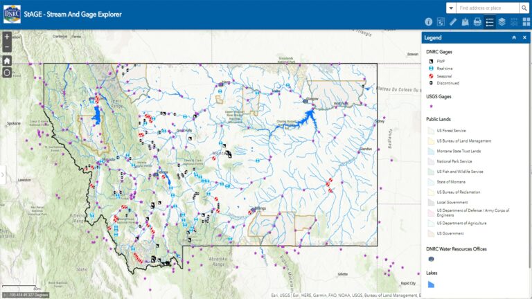
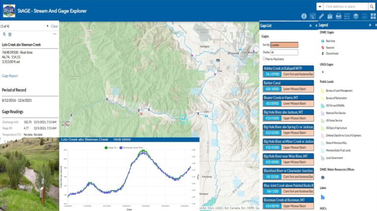
Created using ArcGIS Online, StAGE includes a host of convenient tools such as selectable maps and gage layers with data sourced from the USGS and DNRC. StAGE also features interactive map symbology with information like the site name, site ID, and links to report pages. These detailed pages about each site contain stage, discharge, and temperature readings for the last seven days, and users can download gage data and statistics as needed.
A New Look for DNRC Streamflow Data
StAGE officially went live in April 2021. The geospatial web application enables water users and managers to make distribution decisions based on real-time information.
StAGE dynamically displays surface water data collected from 29 DNRC streamgages, expanding the capabilities for both short- and long-term water resource planning, such as developing water budgets, assessing local and regional water supplies, and evaluating opportunities for increased water storage. Users can now visually explore Montana’s surface water locations to get detailed reports about streamflow and thereby make more informed decisions regarding water conservation.
In addition to providing data from the DNRC streamgage program, StAGE provides access to data from seasonal and historical gages used by the DNRC in past water projects as well as surface water measurement sites at state-owned dams and canals. Select sites even provide groundwater elevation and water quality data.
“This is a great example of connecting water management professionals, recreationists, and the people of Montana to valuable data they need on a daily basis, whether for work or play,” said Amanda Kaster, director of the DNRC.
StAGE has already supported Montana’s residents in the development and implementation of local drought and flood management plans while promoting public awareness of Montana’s water resources for recreation, tourism, irrigation, and fishery management. It also serves as an invaluable resource for water commissioners regarding enforceable court decrees related to water distribution.
Using ArcGIS technology, StAGE has not only streamlined the DNRC’s method of data collection but also created a public resource for Montana residents and water managers alike to more easily access and understand data about their state’s water.