
Tidal forces move the ocean day in and day out, just as wind creates the waves that crash into our shorelines. This constant push and pull means that ocean tides and waves carry the promise of practically unlimited clean, renewable power, if we can reliably convert their kinetic energy into electricity.
In fact, according to the US Energy Information Administration (EIA), the annual energy potential from waves off the Atlantic and Pacific coasts of the United States could be as much as 2,640 terawatt-hours (TWh)—a unit of measurement equivalent to outputting one trillion watts for one hour. That’s roughly 64 percent of the country’s current yearly consumption.
As the EIA estimates that the global demand for energy rose more than 17 percent between 2019 and 2022, harnessing that power would be no mean feat. Oil, coal, and natural gas continue to dominate the energy industry, and the need for cleaner, more renewable sources of power grows more dire each year.
Though ocean energy generation technology is still in its infancy, researchers at MaREI—a center for energy, climate, and marine research and innovation that is coordinated by the Environmental Research Institute at University College Cork in Ireland—are making waves by developing a freely-available, GIS-based tool that can identify where ocean energy devices are most feasible and practical.
Location, Location, Location
A substantial piece of MaREI’s efforts to help provide clean energy with ocean waves is the Selkie project, which uses GIS and other technology tools in the development, testing, and improvement of ocean energy devices.
“Selkie is a cross-border project aiming to boost the marine energy industry in Wales and Ireland,” said Ross O’Connell, a work package leader on the Selkie project. “We are bringing together leading researchers and businesses to advance the development of the wave and tidal energy sector.”
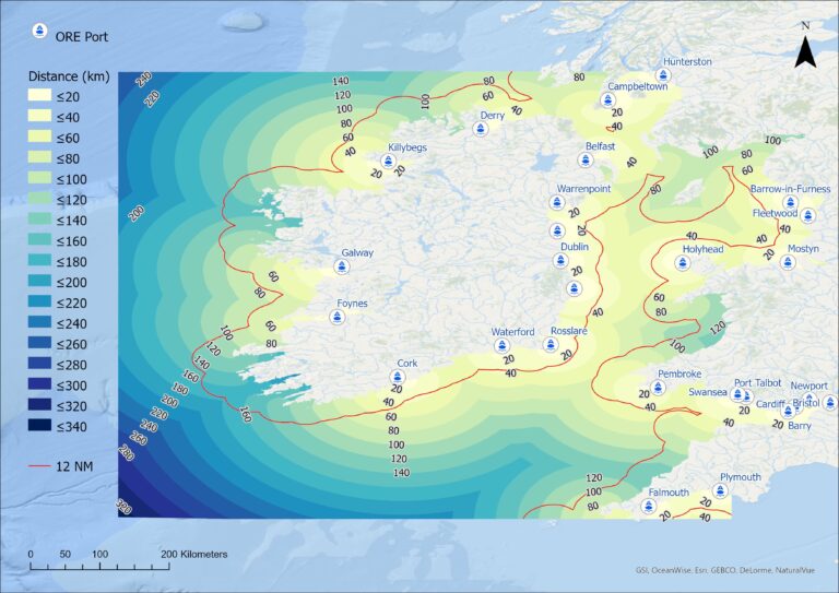
While Ireland and the western coast of the United Kingdom—the pilot project area for Selkie—have extensive marine areas theoretically ideal for ocean energy generation, only some offshore areas are suitable for the installation of energy conversion devices. Some areas are suitable for certain types of ocean energy devices, but not others. For instance, turbines that generate electricity using tidal streams are most effective in narrow straits, while devices such as buoys that harvest power from waves are placed along coastlines, and would not be practical in similar sites.

What researchers needed was a way of evaluating which areas are appropriate for individual devices—a techno-economic (TE) assessment, often referred to as techno-economic analysis (TEA).
A techno-economic assessment is a method used to analyze the economic feasibility of a process or service. It estimates capital and operating costs versus revenue generated based on technical and financial parameters.
According to a 2019 study from the US Department of Energy, commercial-grade tidal energy generation could cost as much as $130-$280 per megawatt-hour. Because other renewable sources of energy such as wind have proven much cheaper, cost has long been a barrier to the large-scale production of ocean energy devices. TE assessments promise a step toward solving this problem, allowing ocean energy project developers and academic researchers to work smarter, not harder, when it comes to deciding whether a site is economically viable for ocean energy generation.
Although the scope of the Selkie project centers around the economic feasibility of ocean energy devices, MaREI also engages in multiple research projects dealing with environmental sustainability. In particular, the SAFEWave project specifically aims to improve general knowledge on the environmental effects and risks of ocean energy through the collection, processing, analysis, and sharing of environmental data around devices operating at sea.
With the TE tool developed by the Selkie team, multiple criteria are used in the site selection process to determine the optimum location for an offshore energy device. Fundamental data include the resource, water depth, seabed characteristics, and the proposed devices’ proximity to onshore infrastructure.
“Other TE tools lack a geospatial component, which limits their analytical capabilities,” said O’Connell. “Geospatial data is critical in determining both site selection and project feasibility in the techno-economic analysis of offshore energy generation. The Selkie team has produced the first GIS-TE tool for ocean energy.”
An App for the World’s Oceans
Developed as a web app using ArcGIS API for JavaScript, the TE assessment allows users to measure project feasibility for a given location, based on metrics such as the cost of an electricity plant.
“Techno-economic analysis is the process used to calculate these metrics,” said O’Connell. “It is relatively nascent and extremely complex, requiring the analysis of a wide variety of technical data.”
To attract potential users of this tool, the team needed the interface to prioritize open accessibility and user-friendliness. The Selkie team decided that a web-based approach would make the most sense, as users wouldn’t be required to download and install an application. Additionally, it was essential that users have access across multiple device types; seamless updates; and secure, centralized data storage. To ensure this, the Selkie team decided on ArcGIS Online as the platform for the web-based GIS-TE.
“The TE process is also inherently spatial in nature, as it is affected by geospatially variable criteria,” said O’Connell. “This includes the annual energy production of the offshore device and its proximity to the nearest port and electrical grid access point.”
The geospatial information collected about the potential sites for stationing wave energy devices is downloaded as NetCDF files, which store multidimensional scientific data. It is then coded in MATLAB, a programming language used for technical computing. Next, the data is exported to ArcGIS Pro for processing into data layers for ArcGIS Online and TE analysis.
“To determine potential locations for positioning an ocean energy device, an analyst can first run a site selection routine with the GIS-TE tool,” said O’Connell.
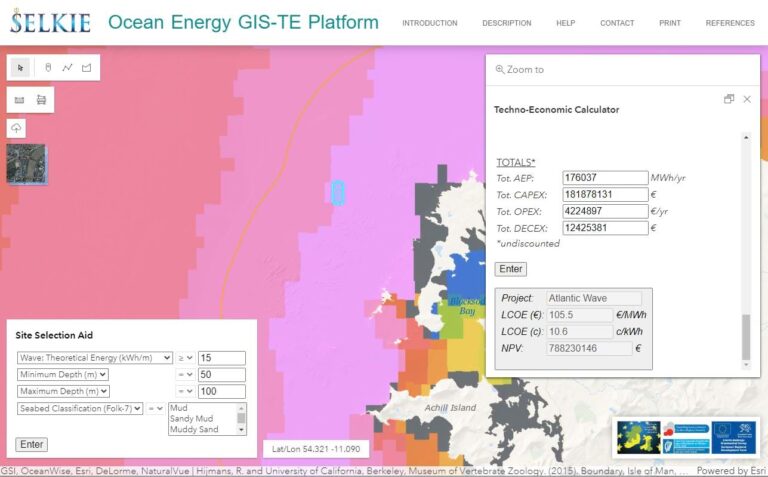
The tool’s display includes a popup window created with the ArcGIS API for JavaScript PopupTemplate. After clicking the proposed location to deploy the energy conversion device or farm, the popup window is activated so the user can begin an analysis of the site. Next, the analyst selects either a wave or tidal energy project type and the energy conversion device best suited for the location. The GIS-TE tool then determines the theoretical annual energy production for that site. Three independent data sources, obtained from buoys throughout the study area, are used to validate the data derived from the GIS-TE.
Because the routine is essentially automated, the process of deciding which sites are feasible for installation of an ocean energy device becomes incredibly simple.
“Modeling the techno-economics of ocean energy farms before implementation is of paramount importance for cost effective decision-making at the planning stage,” said O’Connell. “We believe that this tool can play a critical part in this process. Because clean, renewable sources of energy are vital in reducing our dependence on petroleum-based energy, we have made the tool freely available for all to use.”
