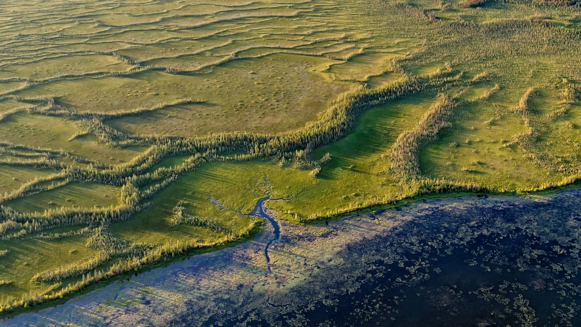
From the outside, it’s easy to think of the province of Alberta, Canada, as predominantly untouched wilderness. But Alberta’s natural environment has endured its fair share of industrial land clearing. In response, environmental restoration organizations like Wild + Pine (W+P) have set out to reverse the impacts of industrial development.
W+P—which manages a 12-hectare site near Pine Lake, Alberta, on behalf of the Nature Conservancy of Canada—aims to transition grassy fields that are no longer suitable for conventional agriculture back to natural forest. After the Pine Lake site was prepared and planted with native seedlings, however, it faced a familiar and deceptively simple problem—weeds.
Weeds often grow fast and can quickly outcompete seedlings, resulting in failed reforestation. But managing weeds is laborious and time-consuming.
“We wanted to be strategic about our approach to weed control,” said Jolan Aubry, field supervisor at W+P. “But we didn’t want to spend hours mapping, plotting, and analyzing things; we needed something efficient.”
To that end, W+P began collaborating with TerraLab, an Australian technology company that produces the STA logger, a location and data logging device.
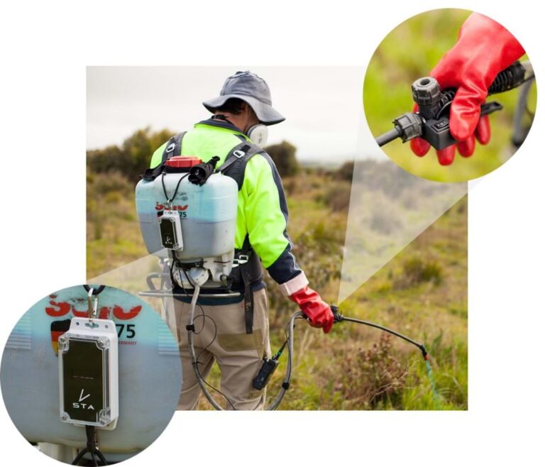
In addition to the Global Navigation Satellite System (GNSS) device that collects location data, the STA logger also has an attachment that connects to the handle of the spray equipment and monitors its activity. When the spray equipment releases herbicide onto the weeds, the STA logger captures the event and records its location.
Recording weed locations on the fly means W+P field operators are effectively doing two jobs at once—mapping and spraying weeds.
From Field to GIS Framework
On a typical day at Pine Lake, Aubry and his team can arrive at the site, put on their safety gear, pick up their backpack sprayers, and get to work quickly.
“There are no complications with signing in, starting projects, or even turning on the device,” said Aubry. “We just start work and go about our business; it’s all automated.”
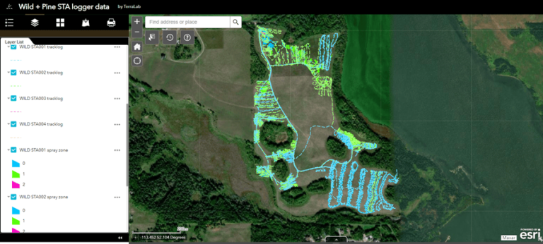
After work in the field is completed, the data is uploaded, processed, stored, and visualized in ArcGIS Online. Processing involves turning the raw data from the logger into three layers. The first layer is a point layer that shows the location of the device every second it is turned on and contains diagnostic information about the device’s status. The second layer is a track log that shows the path the unit traversed while operational, whether spraying or not. The polygon layer, also called the spray zone, represents where herbicide was applied to the ground.
“Before using the STA loggers, we relied on site drawings, written description, and photos to communicate site conditions to clients,” Aubry said. “Spatial elements were rarely included in reports, if ever.”
Processed layers are appended to a hosted layer in ArcGIS Online and shared with W+P through a web application. W+P uses Esri web mapping tools to export data for reporting and compliance.
“We now embed STA logger spatial data into every report sent to clients,” added Aubry. “STA logger data helps us communicate exactly what work we performed on the site inclusive of time, footprints, weed locations, species treated, and spray intensity. We’re now able to provide clients site data so comprehensively that it rivals having boots on the ground.”
Conservation through Analysis
The STA logger web app also enables W+P to consult STA logger data in the field. When working in an area that has been sprayed recently, a user can quickly determine where the last field supervisor finished and pick up the work from there. Additionally, using the time slider function, the user can observe where weeds were last season and focus on those areas.
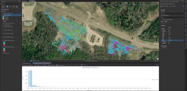
STA logger data is also uploaded into ArcGIS Pro, where the statistics tools and charts available make it a simple process to gain greater insight into this data and leverage it for future reforestation efforts.
For instance, using the tools available in ArcGIS Pro, W+P estimated that in June and July 2021, W+P operators sprayed 1.78 hectares, or 6.5 percent of the site. This is a key output for any organization involved in the management of weeds and can be repeated at set intervals to track a site’s progress over time. Furthermore, it is far more precise and replicable than conventional methods of estimating weed control such as visual appraisal. Users with authoritative data of their site boundaries can use a more accurate polygon and integrate it into automated solutions.
If a particular set of metrics are critical for an organization or project, the analysis workflow can very easily be developed into a geoprocessing model, scripted in ArcPy, or displayed in a dashboard created with ArcGIS Dashboards.
A host of statistical outputs can be applied to STA logger data using ArcGIS Pro. Some statistics commonly assessed by STA logger customers include the distance operators travel in a day, the area they spray per day, the ratio of distance traveled to an area sprayed, and the number of trigger presses per unit area (as a proxy for planted tree abundance). Whatever metric is important to weed managers, STA logger data serves as a first step.
The use of geospatially oriented tools like STA logger and ArcGIS web apps is an important stage in the technological modernization of reforestation and conservation, which in turn has empowered practitioners like W+P with the innovative tools needed to create the old growth forests of the future, one weed at a time.