
Want a clearer view of the world in your maps? You can now use World Imagery Clarity, currently in beta. It’s a new view of World Imagery in the Living Atlas of the World. World Imagery Clarity delivers imagery from the Esri archive that may be clearer and/or more accurate than what is available in the default World Imagery basemap.
The default World Imagery basemap is designed to present the most recent, high-quality imagery available. World Imagery Clarity is an alternative view, enabling users to access imagery from the Living Atlas archive that may not otherwise be available. The imagery in this view may be older than the default imagery, but it can be used to support use cases in which the image clarity or accuracy is more important than the image being the most current.
Clouds Vanquished
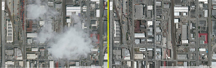
In comparing imagery from both World Imagery Clarity and default World Imagery side by side, it’s crystal clear as to why using World Imagery Clarity can be advantageous in some cases. Look at the area shown below, near Seattle, Washington. You can see clouds and cloud shadows in the World Imagery on the left. On the right is the imagery from World Imagery Clarity, taken in the same location. The imagery may not be as recent, but it is obviously clearer.
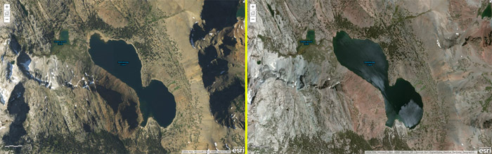
Views of nonurban areas also benefit from World Imagery Clarity. The area shown below is near Yosemite National Park. World Imagery, on the left, is more recent but has long shadows hiding some of the details. World Imagery Clarity, on the right, eliminates the shadows, providing greater detail.
How to Use World Imagery Clarity in ArcGIS Online
To use World Imagery Clarity as your basemap, follow these steps:
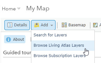
Step 1. Using the Map Viewer, Click Add, then choose Browse Living Atlas Layers.
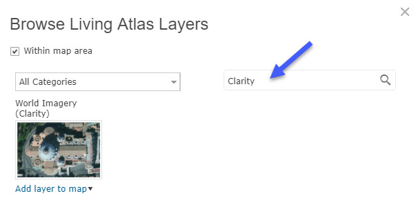
Step 2. Search for Clarity.
Step 3. Click the Add layer to map drop-down arrow, then choose As Basemap.

World Imagery Clarity is now your basemap and will be saved with your map.
You can use World Imagery Clarity anytime you want. Experiment to see which imagery view you prefer in your particular map area. Also, an ArcGIS Online administrator can add it to your organization’s basemap gallery. See the ArcGIS Online Help topic Configure map.