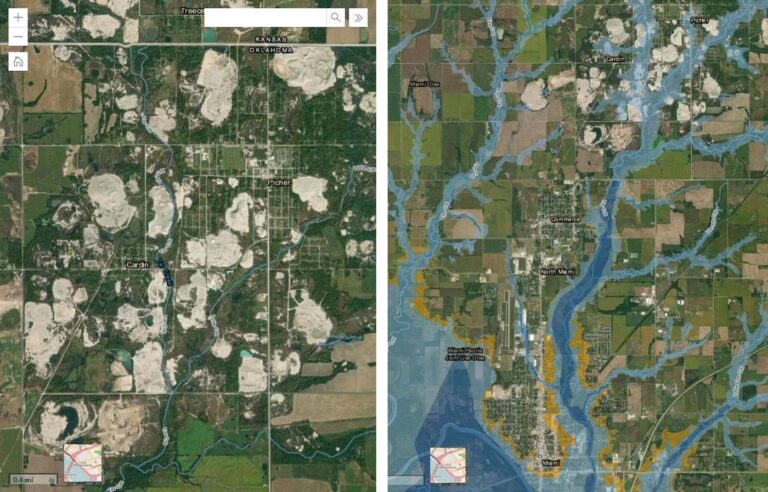
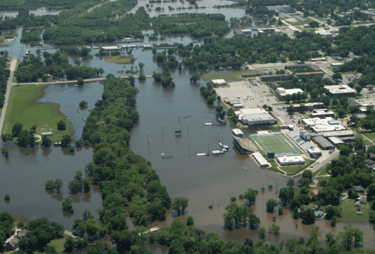
The City of Miami in northeastern Oklahoma has experienced annual flooding for decades, including two 100-year floods in the past 15 years. In this floodplain lies the Tar Creek Superfund site, which contains a massive lead and zinc mine.
To illustrate the relationships between floodwaters and legacy mine waste from the site, the Local Environmental Action Demanded (LEAD) Agency created the Tar Creek Superfund and Floodplain map with ArcGIS Online, in partnership with the American Geophysical Union’s Thriving Earth Exchange program. The map shows the potential for the mine waste to contaminate floodwater and is helping to educate the community about their flood risks, some of whom did not know their homes were located in a floodplain, much less one that could be carrying toxic floodwaters.
The dozens of independent lead and zinc mining operations located in Ottawa County, Oklahoma, closed in the 1970s after 80 years of operation and left 75 million tons of tailing piles, also known as chat, contaminated with lead, zinc, arsenic, cadmium, and manganese. The site was designated as a Superfund site in 1983. While over $300 million have been spent on remediation, full cleanup remains decades away.
Consequently, the nearby Tar Creek, named one of America’s most endangered rivers, is contaminated by runoff from the chat piles and the 1.5 million gallons of acid mine water discharged from a contaminated aquifer daily. When Tar Creek floods, these floodwaters flow through the Superfund site, picking up and carrying metals downstream, leaving them behind as waters recede. The chat piles lie within the 100-year floodplain, and these events are becoming more and more common; the community experienced a 100-year flood event in 2007 and again in 2019.
In response to the health and environmental risks resulting from the Superfund site, LEAD Agency was founded in 1997 to advocate for the health and safety of the people living in Miami, Oklahoma, and the surrounding areas in northeast Oklahoma.
The Tar Creek map was originally designed to better communicate to policymakers, agency officials, and the general public flood-related risks the community faces. However, throughout the project, the uses and users of the map have evolved. Versions of the map have become tools for environmental justice everywhere, from farmer’s markets to Washington, DC. And the community members, including government officials, have added new layers and used the map in unexpected ways.
Expanding the Focus
Originally envisioned as a hydraulic modeling and mapping study, the Tar Creek Superfund and Floodplain map soon took on a new focus due to data availability and the capacity of the all-volunteer team. Ultimately, the LEAD team set out to create an interactive and dynamic web map showing the floodplain and potential sources of contamination.
The team compiled available data sources from community members, the state, and the county. While the original goal was to focus on the City of Miami, the nature of GIS data sources in Oklahoma meant the project team could more easily map the entire county than a single city. The map reached further north than was originally intended, which meant the team could highlight chat piles located in Ottawa County floodplain zones.
The web map was created using ArcGIS Instant Apps. With this format, a streamlined version of the map could act as the landing page, and additional layers could be added as requested by community members. The team shared draft versions of the maps with community stakeholders for feedback. Community members often suggested layers to add and contributed their own GIS data.
Resident Gina Manders, for instance, expanded the map by donating data, generated as part of her certificate in geospatial analysis coursework, from a 2007 flood in which the Federal Emergency Management Agency (FEMA) mandated the demolition of some properties and allowed repair to others. She later used the map to fight the construction of a proposed high-density housing development on greenspace within the floodplain. She added an image of a proposed housing development to show that it would be located within a floodplain, begin a conversation about the consequences of replacing open land with impermeable surfaces, and advocate for safer building practices.
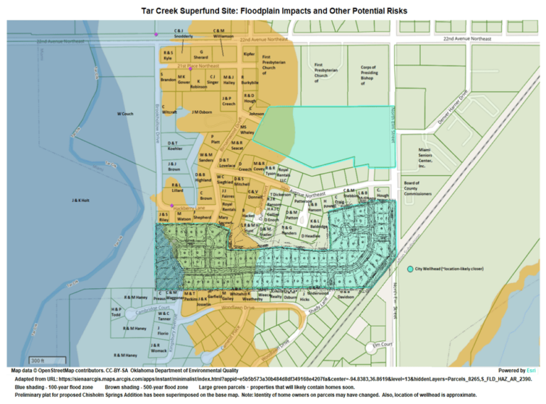
To further balance the competing needs of a streamlined version of the map for some community members and a more detailed version for others, the project team decided to create two versions of the web map. One is public-facing and shared widely. This version includes the most important layers for helping community members understand their flood risks. A second version of the web map includes all relevant GIS layers for the county and is used internally or shared with specific stakeholders.
The project team added data layers from multiple sources, including data from the Oklahoma Department of Environmental Quality, showing homes where lead-contaminated topsoil was removed and replaced with clean soil. Combining this data with FEMA floodplain data vividly demonstrates the need to investigate whether previously cleaned yards are being recontaminated by floodwaters loaded with heavy metals.
Charting a Community Response
When LEAD Agency staff show elected officials floodplain maps and chat piles located in the floodplain, the message has a tangible impact. The ability to direct those officials to geographic evidence of the environmental impact of chat piles makes community advocacy work more effective. For example, the map is currently being used as part of a community flood survey asking residents to voice their opinions about a proposed rise in a local reservoir, the potential to exacerbate already devastating flooding, and whether residents would like assistance moving to safer housing.
Thanks to a donation from a resident, LEAD Agency has also made postcards using images of the map. Residents are invited to write to the Federal Energy Regulatory Commission (FERC) to share their experiences living upstream of the massive Grand River Dam in an area subject to regular flooding and how they feel about the proposed raising of the dam’s water level. Large format printouts of the map are used as an engagement tool at community events such as farmers markets, where residents sign petitions and use red sticker dots to demonstrate where they live relative to floodplain boundaries.
The current phase of the project involves transferring ownership from LEAD Agency’s community science partner, located in upstate New York, to LEAD Agency staff and a local mapping partner. This will allow the map to more easily support local knowledge and continue to evolve as local needs change. This transition and handoff of the map were made possible through Esri’s Small Nonprofit Organization Grant Initiative and Adopt a Nonprofit Grant program. Through this transition and beyond, the Tar Creek Superfund and Floodplain map will continue to grow richer, and more capabilities will be added as it is examined, used, and adapted by the community.
About the authors

Rebecca Jim

Martin Lively

Earl L. Hatley

Jessica Tran