
The state of Minnesota is more than just its heavy winters, abundant lakes, and seasonal swarms of mosquitos. In fact, the region sports an incredibly robust and interconnected GIS community that is active across industries such as conservation, education, and transportation.
This statewide pattern of collaboration is no accident. In 1988, a group of GIS and land information system (LIS) professionals came together to form the Minnesota GIS/LIS Consortium, a professional organization dedicated to developing and supporting the GIS/LIS community in Minnesota by providing a forum for GIS users and data producers to communicate and share information.
Today, the consortium offers resources such as professional workshops, educational outreach, and salary surveys that help GIS professionals get the most out of their careers. It has received the Minnesota Governor’s Commendation Award for supporting and promoting the use of GIS in the state for over 25 years and boasts over 600 members from many public and private organizations across the state.
What the consortium did not have until recently, however, was a platform to showcase its members’ work. Plenty of resources, including those provided by Esri, include examples of impactful and well-crafted GIS work, but the consortium wanted to enable its members to readily find examples from their own community.
Putting Minnesota GIS Professionals Front and Center
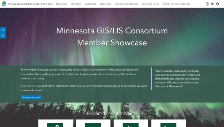
In late 2022, the consortium decided to launch an online Member Showcase using ArcGIS Hub.
Conceived as a platform where Minnesota GIS professionals could both submit their own projects for inclusion and be inspired by the best of their peers’ work, setting up the showcase initially required a huge amount of outreach.
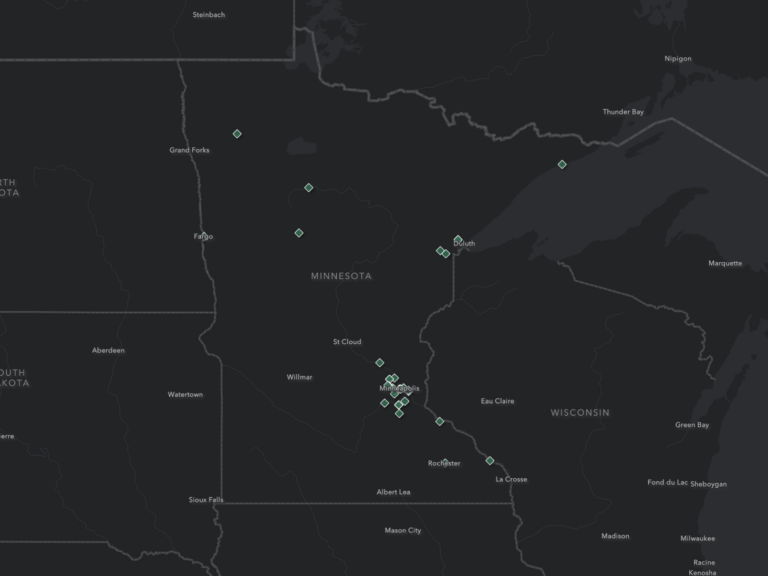
Consortium members made cold calls and scanned city and county websites for high-quality GIS projects. They promoted the Member Showcase website on their social media channels and used ArcGIS Survey123 to create a submission form GIS users could fill out to share their work. Using this geoenabled survey allowed them to curate an interactive map showing where people who had submitted content were located. This map, embedded on the Member Showcase site, provides visitors the opportunity to explore a growing collection of inspiring examples from across the state’s professional GIS community.
Once the call went out, the community responded.
The showcase now includes over 40 maps and apps from more than 30 organizations across the state and contains a vast array of GIS use cases. Three Rivers Park District submitted a dashboard to track progress on its Operation Osprey reintroduction program. The City of Maple Grove’s Neighborhood Information app lets residents look up information about their property and community—including zoning, floodplain, school district, utility providers, election polling locations, recycling and garbage pickup days, and more—with a simple address search. The University of Minnesota takes readers on a 60-year journey through the Cloquet Forestry Center with ArcGIS StoryMaps.
The diversity of maps and apps featured in the Member Showcase hub site gallery speaks to the pervasive impact the Minnesota GIS community has across organizations and industries.
“It’s been amazing to see the wide variety of submissions from around the state,” said Amanda Huber, the main architect behind the showcase’s ArcGIS Hub site. “Hopefully it inspires current and emerging professionals to see what new things they can do with GIS.”
A Legacy of Support
The consortium views the Member Showcase as just another in the long line of professional development resources it offers its members.
Prior to the showcase, the consortium launched the Member Spotlight Series, which it continues to publish. Created with ArcGIS StoryMaps, this collection includes over 20 stories from members ranging from emerging professionals to retirees, and everywhere in between. “We’re super proud of the work our members are doing,” said John Nerge, a member of the Professional Development Committee, the group responsible for member engagement. “The [Member] Spotlight Series is a way to recognize individual members and share their GIS journeys. The showcase is a partner gallery we have created. Together, they celebrate both our people and their work.”
Additionally, the consortium hosts professional workshops in the spring and an annual conference in the fall. It does a considerable amount of work engaging with the K-12 and higher education communities in Minnesota to promote the use of GIS through grants and mentoring programs. “We are committed to ensuring all students have every opportunity available to connect classroom learning to real-world experiences,” said Jessica Fendos, consortium board chair.
To promote equitable access to career opportunities, the consortium has also formed a diversity, equity, and inclusion (DEI) committee to collaborate with other DEI organizations in the state to create scholarships, internships, and mentorship opportunities for students and emerging GIS professionals from diverse backgrounds.
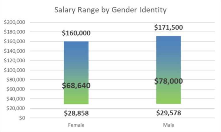
Moreover, the consortium conducts a biannual salary survey and reports that information to its members. The most recent survey detailed salary trends across a myriad of career variables including job title, years of experience, and technical proficiencies. It provides data on salary gaps based on gender, racial, and ethnic identities, which, like trends across all states and industries, persist in the local GIS workforce. The consortium hopes that exposing these trends will help apply pressure to eliminate them over time.
Marty Mollenhauer, cochair of the Professional Development Committee, sees the showcase as one more tool the consortium is using to fulfill its mission of connecting and supporting its statewide GIS community. “I was first introduced to the consortium during college as a geospatial analyst intern,” he said. “Since then, it’s been instrumental in nearly every step of my career.”
For more information, follow the Minnesota GIS/LIS Consortium on social media (@MNGISLIS on most platforms) or contact the Professional Development Committee at profdev@mngislis.org.