Guests of the Bess Bower Dunn Museum of Lake County in Illinois Use Esri Story Maps to Learn about the Area’s Past
There’s a famous saying that beauty is in the eye of the beholder. But at the Bess Bower Dunn Museum in Libertyville, Illinois, local history is literally in the spyglass of the beholder, thanks to Esri Story Maps.
With the motto “Arrive Curious. Leave Inspired,” the museum—operated by Lake County Forest Preserves—is dedicated to telling the stories of Lake County’s history, people, events, and nature areas through exhibitions, education, and community engagement. Lake County is in northeastern Illinois and borders Wisconsin to the north; Lake Michigan to the east; and Cook County, home of Chicago, to the south.
One way the Dunn Museum chronicles history is with Esri Story Maps apps. The apps combine authoritative maps with text, images, and other multimedia content to tell stories, in this case, about the people and the land that made Lake County the unique place it is today.
Museum staff wanted visitors to be able to explore the story maps interactively. So they embedded Story Map Swipe and Story Map Spyglass into the five Story Map Series apps they built to highlight the history of 17 preserves, conservation areas, and notable homes and farms.
The story maps were then displayed on touch screen devices at kiosks placed throughout the museum.
By touching and dragging the Spyglass or Swipe tool in the apps, guests can compare historic aerial imagery or maps with recent aerial imagery to see how the landscape has changed over time or to learn the history of the area.
“The story maps have been very successful [in] helping visitors connect the stories we present in the museum’s galleries with land on which these stories took place and are today protected as forest preserves,” said Andrew Osborne, superintendent of educational facilities for Lake County Forest Preserves.
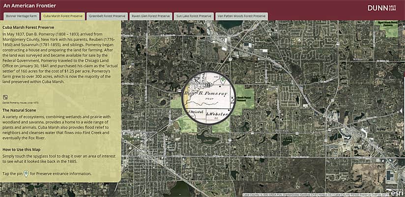
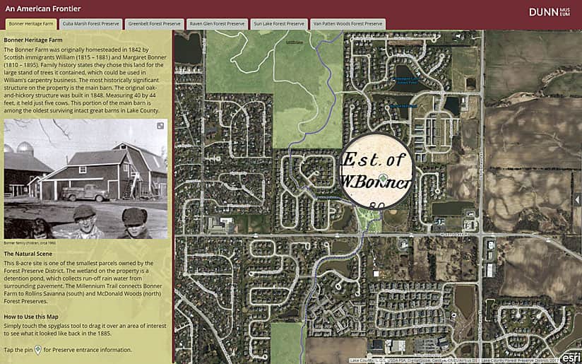
For example, in the An American Frontier story map, visitors can use the Spyglass tool to peer through a current web map of Cuba Marsh Forest Preserve in Deer Park to inspect an 1885 parcel map that shows land owned by an early settler named Dan B. Pomeroy. Pomeroy’s 300 acres, which he farmed, are now part of the preserve’s 781 acres. The story map tells of how Pomeroy bought his first 160 acres for $1.25 per acre from the federal government and includes a photograph of the Pomeroy house taken in about 1970.
“The use of the spyglass and historical plat maps allows visitors to see where their neighborhoods are [located] and which early settlers owned the land in the late 1800s, bringing the historical stories closer to home,” said Robin Hill, exhibit designer for Lake County Forest Preserves.
Other story maps at the Dunn Museum highlight land that indigenous people once inhabited that is now part of forest preserves, historic homes and farms, and early homesteaders. One settler profiled was Alfred Bennett, the son of freed slaves, who moved to Lake County in the early 1840s and bought 40 acres in what is now Greenbelt Forest Preserve in North Chicago. Using the Spyglass tool, museum visitors can view a hand-drawn plat map to see what the area looked like in the 1840s and compare it to a digital map of the land today. (You can read Bennett’s story by clicking the Greenbelt Forest Preserve tab.)
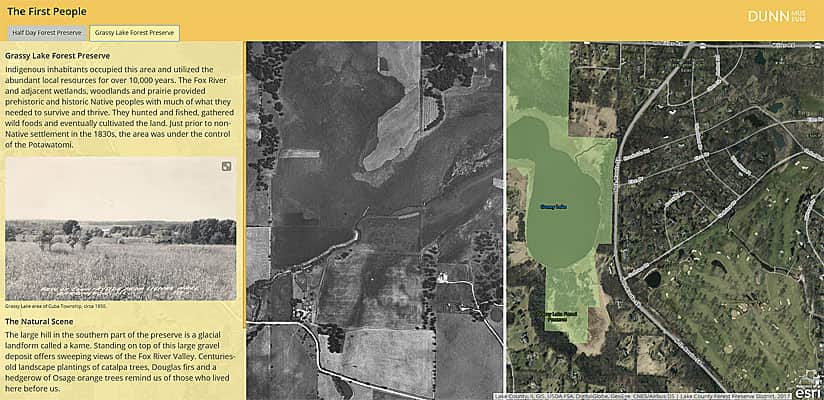
The museum also used the Swipe tool in several story maps including The First People, which shows, for example, how much the area around Grassy Lake Forest Preserve in Lake Barrington has developed since the 1940s. Visitors can swipe a gray bar to the right and left on the map to compare a 1946 black-and-white aerial image of the land around Grassy Lake, Lake Barrington, and Honey Lake with a 2017 aerial image.
“The historical aerial photographs allow the visitors—and me, as a natural areas land manager—to better understand how historic land-use patterns, such as farming, grazing, and wetland draining, have shaped the landscapes we see today,” said Ken Klick, a restoration ecologist who has been restoring and managing forest preserve land for more than 24 years. “The insight provides valuable information when restoring wetland systems, prairie, and woodland habitats.”
Getting the Most from ArcGIS
Founded in 1958, Lake County Forest Preserves protects nearly 31,000 acres of land for conservation, recreation, and education within 65 sites countywide. These include forest preserves; conservation areas; a cultural center; three golf clubs; a community garden; and over 203 miles of trails for hiking, biking, cross-country skiing, and horseback riding.
Lake County Forest Preserves also operates the Dunn Museum, which used to be the Lake County Discovery Museum. That museum operated for 40 years out of converted farm buildings at Lakewood Forest Preserve in Wauconda. The Lake County Discovery Museum closed in September 2016 to prepare for a move to Libertyville. The process of moving 20,000 artifacts and 1,000 linear feet of archival material and transforming new gallery space took over a year to complete.

When the museum reopened in the General Offices of Lake County Forest Preserves in March 2018, it had a new name and brand and a new tool—in the form of story maps—to share the stories of Lake County’s past and present.
I joined Lake County Forest Preserves as a GIS analyst in January 2016. My responsibilities include working with each of our nine departments to create and manage spatial data and GIS applications. We’ve used GIS since 1982 for trail maps, controlled burn records, and natural resource and infrastructure assets inventories. However, most of our spatial data was isolated in the desktop computer environment and stored in data silos.
By using ArcGIS Online (and, in the near future, ArcGIS Enterprise), Lake County Forest Preserves has centralized its GIS data and made it available to all staff through web applications and mobile apps, including Collector for ArcGIS. It was the use of these applications that caught the attention of Dunn Museum staff, including Hill and Osborne, and exhibitions and collections manager Steve Furnett. After meeting with them to discuss incorporating GIS into the new museum, the decision was made to use the touch screens to display story maps on Lake County’s forest preserves to show visitors firsthand where historical events took place.
Creating the Story Maps
Hill originally thought the Story Map Tour app would work best for the interactive displays but ultimately selected the Story Map Series app template because it features multiple tabs at the top of the interface. Each tab could be used to tell a story about a different forest preserve and be presented on one screen.
As staff created the museum’s new galleries, curators began to assemble stories that were related to the forest preserves. These included narratives on prehistoric Lake County, Native American people who lived in the area until the early 1800s, the settlers who arrived later and started homesteads, and innovation and preservation efforts.
As text and photographs from the museum’s historical archives were submitted for inclusion in the story maps, a point feature class that included each forest preserve’s address, coordinates, hours of operation, acreage, and trail mileage was published to ArcGIS Online.
The hosted feature layer was then incorporated into web maps within ArcGIS Online that each story map tab sources. The points are an important part of the story maps, as they direct museum visitors to the location on the land where historical events happened. An aerial basemap was also chosen to show visitors trees, buildings, lakes, and other natural and man-made features of the preserve’s landscape.
Embedding Apps inside Story Maps
Through the efforts of the Lake County Department of Information and Technology’s GIS Division, aerial photography dating to 1939 and historical plat maps going back to the 1840s were digitized and made available as services in ArcGIS Online. Using these historical basemaps and the Story Map Swipe and Story Map Spyglass app templates, I was able to easily create a look into the past for each of the forest preserve tabs and to embed the apps into the Story Map Series apps (see the ArcGIS Blog post about embedding apps inside story maps).
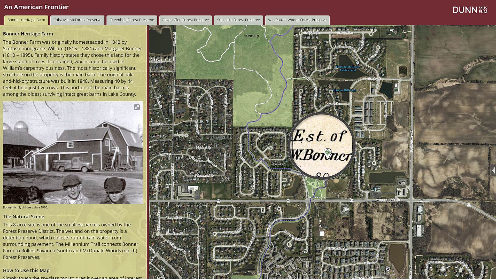
Using the historical plat maps from 1861 and 1885, included in the story map An American Frontier, museum visitors can tie the narrative text to the names on the plat maps. Take, for example, a story about Bonner Heritage Farm, a historic farm preserved by Lake County Forest Preserves and the Bonner family in 1995. Museum visitors can use the Spyglass tool to locate the Bonner name in two locations on the 1885 plat map, including the parcel that currently houses the Bonner Heritage Farm.
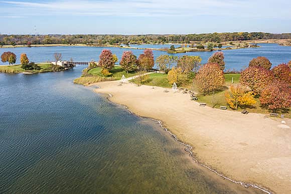
The most impressive Story Map Swipe map may be the Innovations and Preservation story map, which highlights the innovations that took place in the county and chronicles preservation efforts, including the establishment of forest preserves. The story on the first tab explains the history of Independence Grove Forest Preserve in Libertyville. This former gravel mine was purchased and developed into a 115-acre lake. By comparing a current aerial photograph of the area with a historical color infrared aerial from 1980, viewers can see the transformation of a sterile gravel pit into an ecological and recreational haven.

Debut of the Story Maps
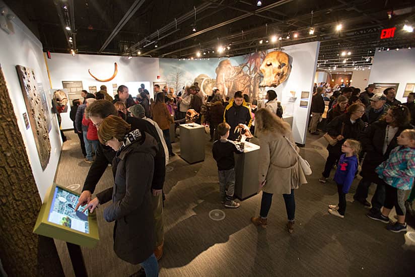
The five story maps created for the Dunn Museum are displayed on 23.8-inch touch screen computers. Since the story maps are hosted in ArcGIS Online, the display computers were locked in kiosk mode by the information technology staff so visitors can’t browse the Internet but can only pan the map, zoom in and out, click the preserve entrance icon, and expand any images in the story panel.
In the first week following its opening in March 2018, 5,281 people visited the museum. The new interactive displays were very popular among adults and children. Visitors discovered the history and locations of the preserves, got to use innovative story maps, and benefited from the collaboration of multiple forest preserve departments.
“In addition to being an exciting interactive [feature] within the museum galleries, [the story maps] also direct visitors out to preserves where additional interpretation is available through on-site exhibits,” said Osborne. “The story maps provide a critical connection between the Dunn Museum and the forest preserves.”
