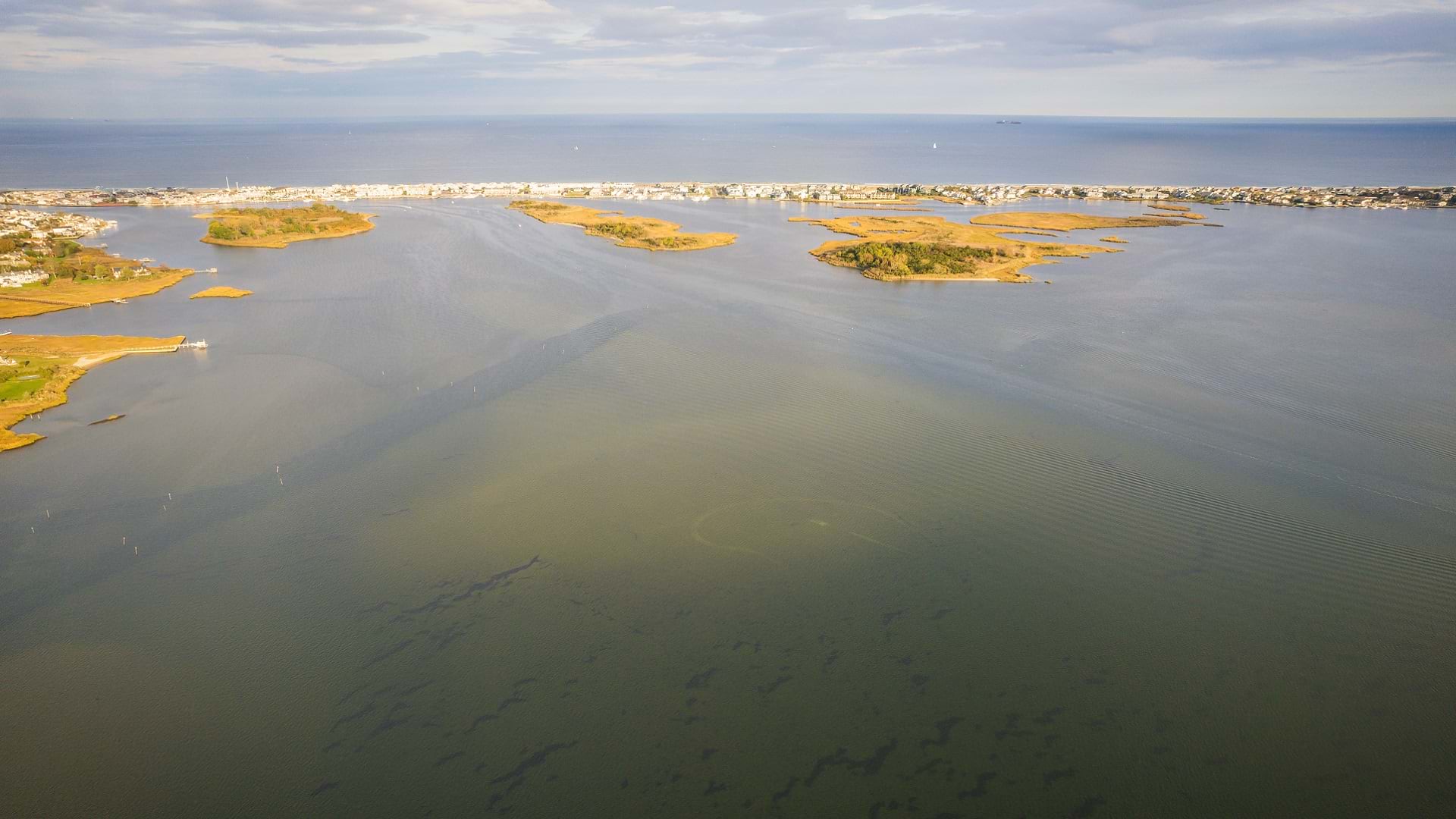
On October 27, 2012—after weeks of research, testing, and field data collection—Chris Kahn, American Water director of unmanned aerial systems and geospatial services, finished mapping all 7,000 water and wastewater utility assets owned by New Jersey American Water in the coastal town of Ortley Beach. The process had required using a time-consuming legacy Global Navigation Satellite System (GNSS) device to map the assets, postprocessing to correct the location data, and entering data manually into ArcGIS software. But the result was worth the effort. Every asset was mapped with decimeter accuracy—a nearly perfect utility map of Ortley Beach.
Two days later, Hurricane Sandy made landfall in New Jersey, causing billions of dollars of damage. In the aftermath, water meters were buried, lids were washed away, and homes were destroyed—sometimes with only a copper pipe sticking up from the sand. The coastal landscape was permanently altered.
Ortley Beach would become known nationally not for its comprehensive map—but for being nearly wiped off the map.
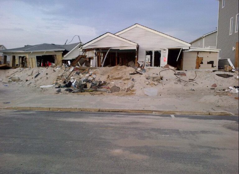
In the days that followed, Kahn returned to the field with mobile crews to help locate assets in the rubble and perform damage assessment. In Ortley Beach, he was able to navigate to assets within seconds, despite the neighborhood’s transformation, thanks to his high-accuracy map. On the same barrier island, mobile crews in neighboring Mantoloking, spent hours to days locating service lines under the rubble.
“All of their tap lines and drawings meant nothing there,” Kahn said. “Measurements were based on references that weren’t there anymore. In Ortley Beach, it took a few seconds to find our assets.”
A Laser-Guided Shovel
After the success of Kahn’s map in Ortley Beach, American Water’s management team asked Kahn if he could map all of New Jersey American Water’s assets with high accuracy. To help quantify the value of such a project, Kahn rode along with mobile crews and observed that each work order took on average 12 minutes to complete, with 10 minutes spent interpreting sketches to locate the asset. With 300,000 work orders occurring per year, Kahn estimated the utility could save 55,000 work hours per year—or $2.6 million in operational expenses—just by having survey-grade maps.
“I wanted to give our crews a laser-guided shovel to every single asset,” Kahn said.
However, the legacy GNSS workflow that Kahn used at Ortley Beach was too time-consuming and error-prone to scale. Kahn needed a high-accuracy data-collection solution that fed real-time GNSS locations directly into ArcGIS mobile apps, thereby eliminating postprocessing and manual data entry.
Kahn settled on the Arrow Gold GNSS receiver from Esri partner Eos Positioning Systems, which uses Bluetooth to provide real-time, survey-grade positions to any mobile device. To provide the GNSS receivers with centimeter-level corrections in real time, Kahn installed six Arrow base stations. This meant the corrections could be broadcast to unlimited utility mobile workers with rover GNSS receivers across the state. Not only did the installation of the base stations eliminate the need to postprocess GNSS metadata, but it also improved the accuracy of the data collection, jumping from decimeter-level to sub-inch accuracy.
Next, Kahn needed a mobile mapping software that was compatible with real-time kinematic (RTK) corrections from the base stations. At the start of the project, Kahn deployed early ArcGIS mobile technology that supported RTK locations. Today, Kahn has standardized the use of ArcGIS Field Maps by his crews.
Millions of Dollars Saved Each Year
While it had taken Kahn several weeks in 2012 to collect the 7,000 assets in Ortley Beach, the new solution was much faster. According to Kahn, it was not unusual to see mobile workers collecting over 1,000 points per day in the most walkable service areas.
“Out of the gate, the data started pouring in,” Kahn said.
Within five years of starting the statewide data collection effort, Kahn’s team had mapped all of New Jersey American Water’s water and wastewater assets with Arrow Gold receivers and ArcGIS Field Maps. According to Kahn, this combination of hardware and software is the most flexible, scalable, and easy to use.
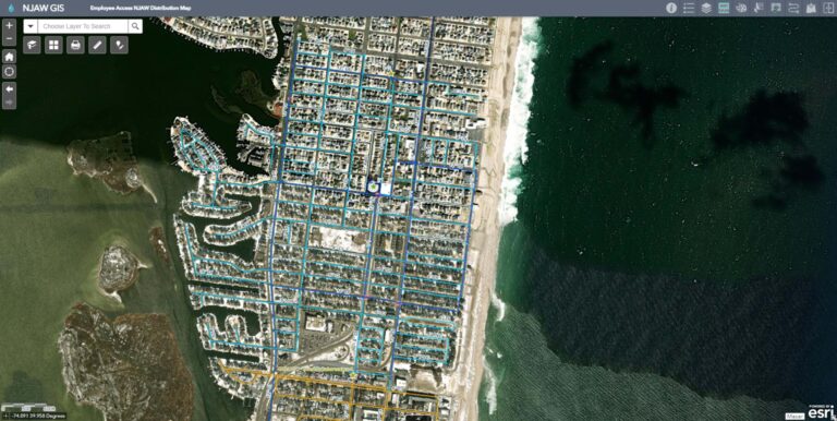
As a result, approximately one million existing assets spanning 10,000 miles of service were mapped with sub-inch accuracy. Along the way, technicians discovered many assets (e.g., hydrants, valves) that had not previously been recorded. They also mapped potential hazards—such as missing lids or grading issues, and leaks that needed to be fixed—and alerted maintenance crews, who responded with prompt interventions.
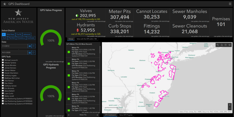
Additionally, being able to visualize data in ArcGIS Dashboards allowed Kahn to facilitate communication with non-GIS stakeholders, including the utility’s management team. For the first time, utility management could see, on an interactive map in real time, the progress of assets as they were being captured.
“They wanted a laser-guided shovel that says, ‘Dig here,’” Kahn said. “Today, in most areas, we have that. Over time, I knew we would be able to accomplish so much more value for the utility. For New Jersey alone, the [return on investment] spoke for itself.”
Now that all existing assets have been mapped, every newly installed asset is also required to be recorded with sub-inch accuracy.
Today, New Jersey American Water saves over $2 million each year from field-operations efficiencies directly attributed to the survey-grade maps. New Jersey American Water has, to date, equipped over 350 mobile workers, including maintenance crews and field service representatives, with ArcGIS Field Maps and Arrow GNSS receivers. The utility has also built a total of 14 Arrow Gold base stations across American Water’s subsidiaries.
“They can walk right up to a service line without having to spend time interpreting sketches,” Kahn said. “We know what we’re saving in operational expenses. However, during emergencies, this is truly priceless.”