
Although the reapportionment of populations through redistricting is one of the hallmarks of the United States governmental system, the lack of sustained and enthusiastic public participation has long been a difficult hurdle to overcome. The expertise needed to refine US Census Bureau data into a usable format and the cost of typical redistricting software often limit the ability of residents to effectively carve a space for themselves in the process, leaving the actual drawing of proposed plans to county GIS professionals.
In 2021, redistricting efforts across the country ran into another roadblock: the delay in census results as a consequence of the COVID-19 pandemic. For the GIS staff of Tulare County, California, this meant a process typically completed in eight months had to be done in three, creating an extra layer of stress and urgency to the drive to involve the public.
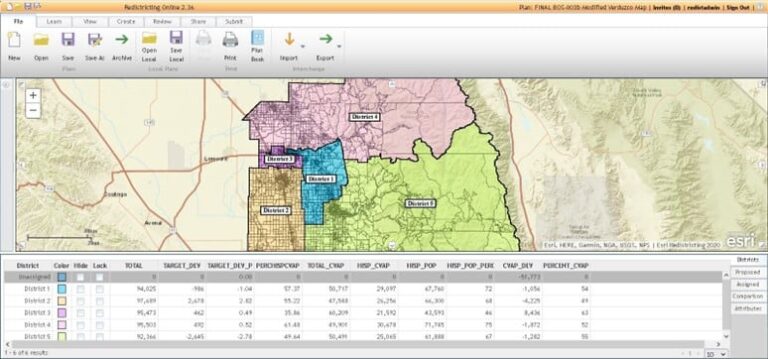
To that end, Tulare County staff turned to Esri Redistricting, a web-based software as a service (SaaS) based on ArcGIS software. Esri Redistricting enables not only government staff but also residents to design and share plans for reapportioning districts in their county. With the help of this tool, redistricting would become a more transparent, collaborative process.
Power to the People
Tulare County’s board of supervisors is ultimately responsible for drawing up the final supervisorial districts, but in May 2020, the board approved the creation of an advisory redistricting commission designed to gather public input regarding boundary changes and present recommendations for adoption.
The commission kick-started the shortened redistricting season by creating a centralized website. Here, members of the public could create an account, learn how to use web applications built with Esri Redistricting, and submit maps for consideration by the board of supervisors. This allowed residents to avail themselves of the same applications and data available to county staff.
The site also included a comprehensive story, created with ArcGIS StoryMaps, to provide background on redistricting as well as information on how the public could get involved.
In total, Tulare County residents made over 65 individual accounts and submitted 22 unique redistricting plans through the site. Most of these plans included revisions and were resubmitted multiple times, indicating continuous engagement with the process. Between the advisory redistricting commission and the board of supervisors, over 50 different plans were reviewed.
In addition, members of the public were invited to attend meetings of the advisory redistricting commission to provide input and suggest changes to various plans. Meanwhile, county staff made alterations in real time on monitors for all attendees to see the effects of each change. With the advent of the new site, public attendance at these meetings skyrocketed. The meetings, spurred by the ease of access and visual simplicity of the redistricting app, became forums for spirited discussion and civic engagement, affording residents greater access, enthusiasm, and insight into the process.
It Takes a Village
With much of the county’s attention geared toward finding ways to further involve the public in redistricting efforts, GIS staff ramped up its work to ensure not only that the public was sufficiently supported but also that the end result would comply with California law and the requirements of the Voting Rights Act.
Crucially, while residents had the option of starting their redistricting plans from scratch, county staff were also able to set up templates within Esri Redistricting based on current supervisory districts with the correct data tables used by the board in making a final decision.
In addition to handling the display of real-time redistricting changes at commission meetings, GIS staff prepared printed maps and PDFs for information packets. Online apps allowed the public to easily compare the current supervisorial districts with proposed plans and past districts. Residents could also point out specific communities of interest—such as those with common cultural or economic interests—they felt should be kept in a single district if possible.
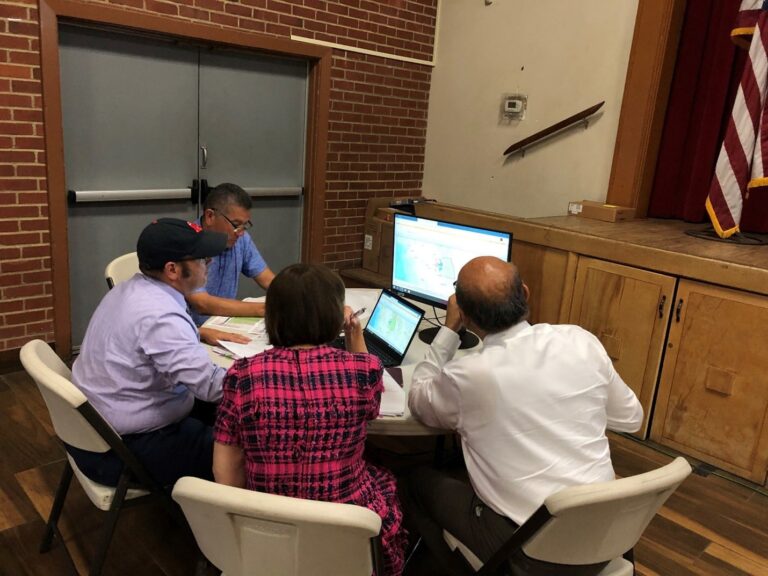
Of course, the work expanded beyond just county GIS staff—county administrative offices supplied senior staff to facilitate the meetings and to put together a citizen commission to review and recommend plans to the board of supervisors. County council legal representatives attended each meeting to give advice on any topic where it was needed.
The engine of this redistricting project, however, was the GIS software itself. By centering the effort around Esri Redistricting—as well as getting the public up to speed through a combination of training classes, app support, and tutorials presented with ArcGIS StoryMaps—Tulare County was able to streamline the redistricting process and generate a strong sense of public engagement at the same time.
Given the increased desire for public participation, it’s easy to see some of the long-term benefits of introducing easy-to-use redistricting software into what has historically been an obscure process. For example, when public scrutiny enters the process at an earlier stage, increased transparency may help tamp down gerrymandering efforts. Making publicly accessible GIS software the standard for redistricting represents a powerful step toward inclusivity, fairness, and access to the fundamental mechanisms of the US electoral system.