If someone becomes ill or falls and gets hurt on a 1.14-mile hiking trail in Cold Spring Harbor State Park on Long Island, New York, local police officers, firefighters, and emergency medical technicians (EMTs) come to the rescue.
But for many years, finding someone who was sick or injured on the hilly, wooded trail could be difficult. The people calling 911 to report medical emergencies often were unable to pinpoint their exact location in the woods. “They [would] just report being on the trail. There was no point of reference. It did leave us with a guessing game,” said James Garside, a Suffolk County police officer who patrols the area.
But thanks to a new system of numbered trail markers erected in the park and a companion map that shows the coordinates of each of those markers, locating someone who is ill or injured has become much easier. Emergency callers can now report the number on the trail marker closest to them. First responders can consult a digital trail map on an Esri Explorer for ArcGIS app, created by the town of Huntington, to obtain the marker’s geographic coordinates and other information that will aid in the rescue.
The information the map provides to first responders shaved about 15 minutes off the response time to a medical emergency that occurred on the trail last year, said Garside, who spearheaded the effort to install the trail markers.
Garside said that on October 15, 2017, a 47-year-old man suffered a heart attack on the trail. The park is a popular, 40-acre area in the town of Huntington, a community of 200,000 people that includes the hamlet of Cold Spring Harbor.
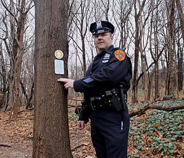
The man had collapsed at marker 108, which is one of 15 small signs placed less than one-tenth of a mile apart from each other along the rugged trail surrounded by oak, red maple, American beech, and other kinds of trees. Using her cell phone, the heart attack victim’s wife called Suffolk County’s Enhanced 911 system and reported the trail marker number, which was posted on the tree that her husband sat slumped under.
Garside and first responders from the Cold Spring Harbor Fire Department sprang into action. Besides being the officer who patrols the area, Garside is trained as an advanced emergency medical technician (AEMT). He consulted the trail marker map, which is available to him on both the Town of Huntington’s Explorer for ArcGIS app and a data terminal in his patrol car.
On the map, Garside could see the details that were important to creating a quick response plan: the latitude and longitude coordinates for trail marker 108, the best access point to get to that site, and suggestions as to the type of apparatus (e.g., a rugged terrain vehicle [RTV] and a Mule litter wheel with a Stokes basket) to use to bring out the patient.
In 2015, Garside had approached the New York State Office of Parks, Recreation, and Historic Preservation (NYS OPRHP) with the idea of installing the trail markers in Cold Spring Harbor State Park. NYS OPRHP assigned a GIS team to map the trail and gather each sign’s coordinates.
The Cold Spring Harbor Fire Department then sent a team in to walk the trail and create its own response determinates. These included a description of the best place to access the trail to get to each marker location (e.g., the south or north end of the trail or a residence specified as being “near the barn”, the type of equipment suited to the terrain at that site, and the best extrication point. That information was then added to the trail marker map.
In the case of the heart attack victim, the best access point to reach him was through private property in the 200 block of Harbor Road/New York State Highway 25A. When Garside arrived—carrying his medical equipment and a Physio-Control LIFEPAK 12 portable cardiac monitor—the property owner was helpful. “He was pointing me in the right direction [toward the trail],” Garside said.
Garside said he reached the heart attack victim’s side in 5 minutes, whereas the typical response time without the accurate trail marker information would have been about 15 minutes.
To bring out the heart attack victim, the Cold Spring Harbor Fire Department used a Mule litter wheel—the recommended equipment listed on the Town of Huntington’s Explorer for ArcGIS app.

But first, Garside obtained an EKG reading from the man and sent the readout to a nearby hospital emergency room. The staff there studied it and called in a cardiac care team so that the physicians and nurses could be in place and ready when the patient arrived at the hospital.
The trail signs, the information available via the Explorer for ArcGIS app, the rescue equipment, and the mobile medical technology—along with the efforts of the first responders, of course—all helped provide a happy ending to the story.
“It’s a blend of old technology with signs, mixed together with new technology. It worked well,” Garside said. “It did save that man’s life.”
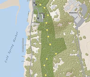
NYS OPRHP’s map of the trail, which displays markers 101 through 115 along with each sign’s coordinates, has been posted at a kiosk in Cold Spring Harbor State Park. Visitors can download a PDF of the map—with the trail marker numbers and coordinates on it—to their smartphones by scanning the map’s QR Code at the kiosk.
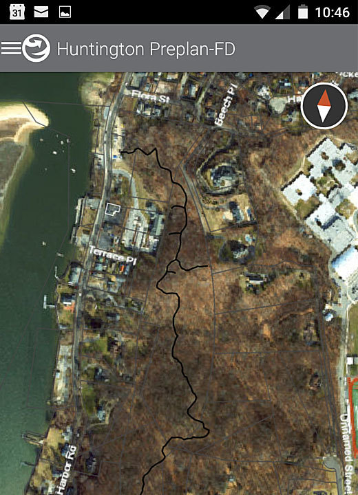
The spatial data from that project, along with the information from the Cold Spring Harbor Fire Department, was shared with the Town of Huntington. The town’s GIS manager, Dave Genaway, said he was alerted to the data by Huntington chief fire marshal Terry McNally.
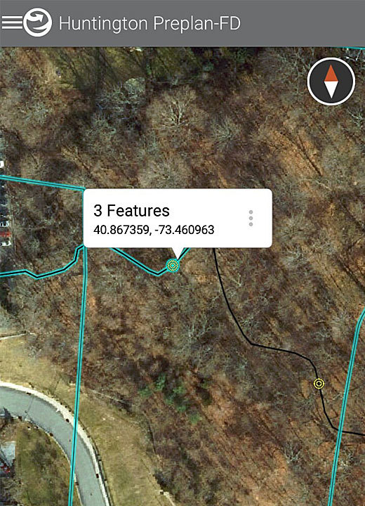
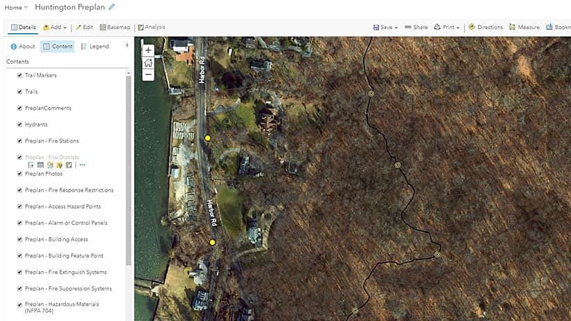
Genaway said the trail marker data was added as a feature layer to the Huntington Fire Preplan application, hosted via the town’s ArcGIS Online organizational account. The Huntington Fire Preplan app contains information about the town’s buildings (e.g., roof materials, known hazards, and floor plans), which helps firefighters plan their response to fires or other emergencies. The preplan and trail marker information also is available to local firefighters and first responders via the Explorer for ArcGIS mobile app.
Genaway said that when users click on a trail marker on the map in the Explorer for ArcGIS app (or ArcGIS Online), the latitude and longitude for that marker appear. “[This] also shows which access point they can use to get to that trail marker in [the most] efficient way,” he said.
Garside hopes that the trail marker system can be duplicated in other parts of the state in the future. But for now, the police officer is pleased that Cold Spring Harbor State Park will be a little safer for hikers and runners. He said that he came up with the idea for the trail marker system after a man had a close call while walking on the trail with his wife in 2015.
“It was National Trails Day, the first weekend in June,” Garside said. “That [incident] was the straw that broke the camel’s back.”
The hiker had fainted on the trail due to a heart condition. His wife called 911 but had no idea exactly where on the trail they were located. “When you are on the trail, to the right or left you see woods,” Garside said, adding that the terrain, with steep hills and many trees, makes it hard for people to stay well-oriented.
Garside said it took about 10 or 15 minutes to find the ill man on the trail, which is basically a footpath and not accessible by ambulance. Other hikers on the trail tried their best to help but were unable to give first responders a good estimate of how far down the trail the man and his wife were located.
Garside’s inspiration: the interstate highway signs in New York that include exit numbers. “I just thought, there’s got to be a better way [that] would take the guesswork out of it,” Garside said. “These trail markers provide that.”

