By Diana Henderson, University of California, San Diego
Located in La Jolla, California, the University of California (UC) San Diego campus is the size of a small city. On a busy day, more than 63,000 students, staff and faculty members, visitors, and health-care patients are on the 1,158-acre (4.7 square kilometers) campus.
Managing a property of this size comes with many challenges, especially with recent growth and development. For example, from late 2016 to late 2023, about 3.4 million square feet (about 316,000 square meters) of new facilities were built on campus. With rising student enrollment and additional development expected, UC San Diego staff are leveraging ArcGIS and location intelligence to manage campus development and upgrade legacy systems and workflows.
Keeping Stakeholders Informed
To explain to the school community how construction projects will affect getting around campus, university project managers send out all-campus alerts before construction fences go up. Consisting of maps and text, these alerts provide descriptions and context of impacted areas. Following review by the appropriate departments and university executives, the alerts are forwarded to the university records department for campus-wide distribution.
Until recently, this process relied on static maps created with whatever campus map was available, along with a wide variety of mapping and graphic design applications—all with different looks and styles. Reviews and edits were tracked using email chains. In addition to visual inconsistency, this approach led to maps that were confusing, lacked context, and fell short of fundamental standard mapping practices. Sometimes, it was hard to see the connection between a map and the narrative. In the worst cases, the alerts failed to convey how construction would affect campus navigation.
A Simpler, Faster Workflow
Beginning a few years ago, with help from a consultant, the university’s GIS department set out to upgrade this process. Not only do the resultant app and workflow better address mobility concerns, they also demonstrate the campus-wide benefits of GIS applications and their interactive, easy-to-understand visualizations. Internally, the GIS team was able to show that GIS can improve efficiency, reduce errors, and enhance decision-making capabilities.
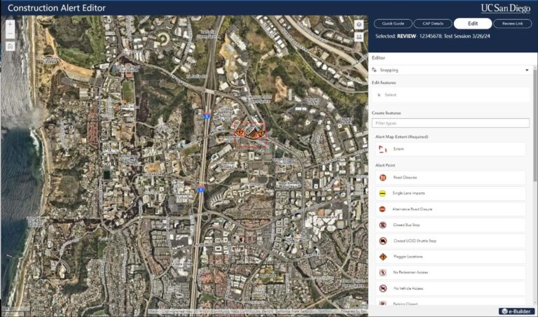
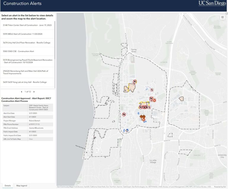
Project managers in various university departments learned how to use ArcGIS applications such as ArcGIS Experience Builder and ArcGIS Dashboards to edit and review maps, text, and other details in the proposed alerts. Once the alerts are approved, a dashboard provides public access. The project also incorporates Trimble Connect—a construction-focused, ArcGIS technology-compatible collaboration tool that helps university staff manage the scope, budget, time, communications, and documentation for each UC San Diego construction project.

The streamlined workflow is faster and more efficient, with fewer back-and-forth interactions between different teams. Standardized symbology and cartography are clearer. For example, intuitive icons, distinct lines, or polygons show fence boundaries, impacts, detours, and road closures. Another time-saver is that, once created, university data layers can be used in different maps and across multiple ArcGIS applications.
With the new system in place, the university community and others can access a consistent and searchable platform for viewing updated construction alerts. In addition, the university community is able to find and use date-dependent project layers, which can save time when a layer applies to more than one construction project.

Considerations for the Future
For UC San Diego, GIS is a relatively new approach to understanding and managing campus resources. Because of this, the GIS team has focused on showcasing projects that demonstrate the capabilities and critical functions that GIS technology provides. In addition, at the heart of the university’s GIS program is the drive to provide services and accurate data in a standardized manner to the people who work at and visit the campus. Leveraging GIS has improved data consistency while providing the university community with a single system of record for visual data on a dynamic and changing campus. Basemap and cartographic standardization help ensure clarity and cohesion in campus messaging. Streamlined workflows also accelerate alert creation, making mobility and accessibility information available in a timely and dependable manner.
Looking forward, the alerts project team has several plans for improvements. One is providing reviewers with the ability to sketch edits directly in the app. Another is to develop an ArcGIS Field Maps app to allow project managers to edit alert features from around campus. In the meantime, the GIS team will continue to monitor and evaluate the construction alert application and identify areas for improvement.
About the Author
Diana Henderson is a GIS program manager for UC San Diego. She received a bachelor’s degree in geography from Oregon State University and is a certified GIS professional. For more information on GIS use at UC San Diego, email Henderson at dlhenderson@ucsd.edu.
