The Virginia Department of Transportation (VDOT) is taking important steps to ensure that truck drivers operate safely by focusing its attention on a shortage of truck parking in the state. Because of a lack of data, it is difficult to know exactly how severe the issue is or where locations for truck parking should be built or expanded. VDOT worked with Fehr & Peers, a transportation consultancy firm, to create the Truck Parking Data Viewer in ArcGIS Online.
Trucking is the backbone of cargo transportation and delivery in the US supply chain—in fact, according to the American Trucking Associations, 72.2 percent of the nation’s freight is transported by trucks on the country’s interstate highway system.
At the Port of Virginia in Norfolk, for instance, the large complex of terminals can process over four million containers annually. Truck transport is a fundamental part of the quick and efficient movement of the freight that flows in and out of the port every day. And with more than 9,200 miles of interstate and primary highways, the state’s road network has the capacity for the high volume of traffic created by the haulage.
When it comes to parking, however, the industry as a whole has historically come up short.
Because truck drivers need to comply with strict Hours-of-Service (HOS) regulations, the parking of their vehicles is high on the trucking industry’s list of critical issues. Regulations require drivers to rest at defined intervals, forcing them to search for truck parking before their allowable drive time expires or while staging for their pickup and delivery slots. The scarcer truck parking is, the sooner drivers must begin searching for parking, resulting in lost productivity and higher shipping costs. Truck parking shortages can also lead to overflow at existing facilities or drivers parking in unauthorized locations, which can result in a safety hazard for both the truck driver and other vehicle operators.
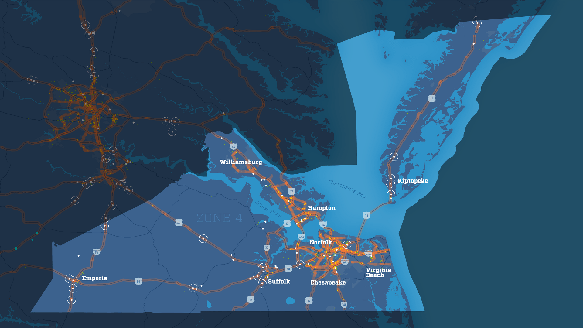
VDOT’s Truck Parking Data Viewer provides a significant step toward remedying this situation. Designed to display data collected and analyzed regarding truck parking events along Virginia’s major highways, creating the viewer is only the first phase of a statewide truck parking study that will allow VDOT to more easily identify patterns and areas of greatest need for truck drivers in Virginia.
Implementing the Viewer
The parking study is assessing the current supply and demand for commercial truck parking in Virginia to fulfill the Jason’s Law Truck Parking Survey, mandated by the US Department of Transportation (DOT). Created in 2012, Jason’s Law establishes a framework to rectify the shortage of long-term parking for commercial motor vehicles on the interstate system. It requires the US DOT to conduct regular surveys in consultation with state DOTs to assess the capability of each state to provide adequate parking and rest facilities for truck drivers.
One of the focuses of the study, according to Erik Johnson, project manager and freight planner at VDOT, is an origin and destination analysis of Virginia’s Interstate 81 and 95 corridors. “These are our most significant truck and through-state corridors and they have significant truck parking deficits,” noted Johnson.
While much of the work of correcting these deficits is still in the future, the Truck Parking Data Viewer has allowed VDOT to make significant progress collecting data that will help the department tackle the issue by identifying places where truck parking needs to be made available, and current rest areas that need to be expanded.
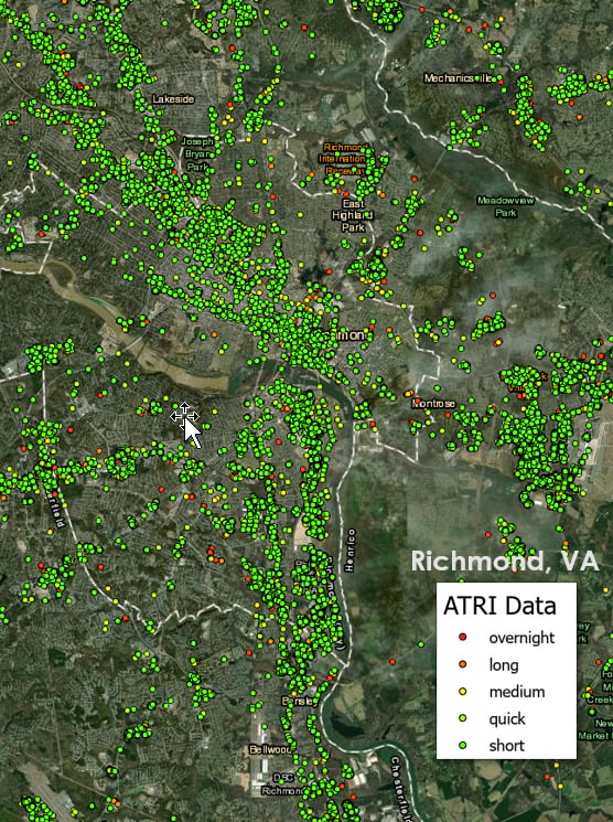
The VDOT truck count database, which includes count station and streetlight data, was used to identify the busiest weeks of the year. Data from the American Transportation Research Institute (ATRI) was then purchased for the eight peak weeks identified by the VDOT to provide the largest sample size and greatest time periods for truck parking demand.
During the selected eight-week period in 2019, 242,547 trucks were analyzed to better understand the demand for truck parking in the state of Virginia. The resultant dataset includes over 247 million records of time and location stamps.
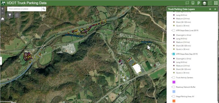
In order to process the ATRI sample data and estimate the full extent of truck parking demand, the team at Fehr & Peers conducted a detailed GIS analysis of both authorized and unauthorized truck parking activity. Types of parking activities were classified based on the duration and location of each stop.
“The analysis included the creation of a buffer layer for roadways, where the buffer width differed based on the roadway type and number of lanes,” said Fatemeh Ranaiefar, freight discipline group leader at Fehr & Peers. “The buffer layer was used to determine if a truck had parked on a highway shoulder, ramp, or other location outside a designated truck parking area.”
This data was then added to the original truck parking data point layer, which was joined to a roadway polygon layer to determine the total number of truck parking instances in each area that met certain conditions, such as a ramp or shoulder, overflow in a truck parking area, or overnight parking.
“This process was repeated for each of the three months studied,” said Ranaiefar. “It was performed iteratively as the methodology was refined. Since it involved several algorithmic steps, a Python code was written which performed all the aforementioned tasks and executed through the Python window [in ArcGIS Pro].”
Python was also used to calculate fields and attributes for truck parking data, such as how long a truck was stopped and whether a stop was “overnight” or “quick,” based on the truck’s stop and start times.
The Road Ahead
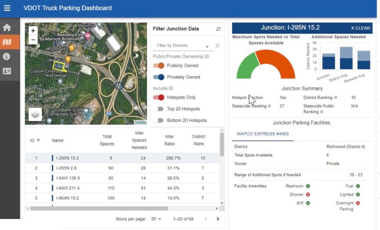
With this phase of the study complete, VDOT has much of the momentum it needs to identify ideal and cost-effective locations for authorized truck parking—as well as places where parking spaces or amenities need to be added—that will allow truck drivers to operate more safely and efficiently.
“In the next phase of the truck parking study, we are developing educational materials to help the public and decision-makers understand the problem and humanize the challenges pertaining to truck parking,” said Johnson.
In the future, more data will need to be studied than just where and how truck drivers are parking their vehicles. VDOT’s 2045 Demand for Truck Parking, for example, is a high-level planning estimate based on existing trucking activities and patterns identified in the Truck Parking Survey. VDOT plans to use this to conduct a more detailed analysis of the existing data and analyze emerging trends in the industry such as autonomous trucks, 3D printing, and major changes in supply chain sourcing.
“There are great opportunities for a deeper-dive analysis of freight data to identify trends, patterns, behaviors, and needs for truck parking,” said Johnson.
