As Americans grapple with extreme heat and drought, longer and more intense hurricane and wildfire seasons, increased flooding, and more severe winter storms, it is important that people come together to help solve complex issues related to the planet’s changing climate.
To help foster cooperation, the White House debuted the Climate Mapping for Resilience and Adaptation (CMRA) portal in September. A collaboration between the Biden-Harris administration and Esri, the portal can help cities, counties, states, tribes, and territories make better decisions about where and how to take action.
Central to the portal is a dashboard that monitors the climate-related hazards that affect communities each day. Site visitors can see where there are extreme heat advisories, active wildfires, coastal flooding warnings, and more.
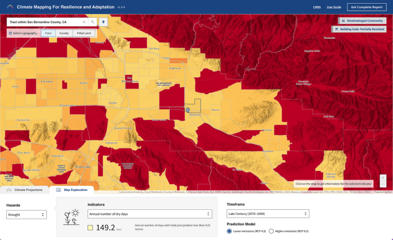
The CMRA Assessment Tool lets users dive deeper to explore current and projected climate conditions in locations across the United States based on whether greenhouse gas emissions are lowered by a lot or a little. In Redlands, California, for example, where Esri is headquartered, it is forecasted that temperatures could reach at least 105 degrees 22–42 days per year by the end of the century, compared with 12–13 days per year now. This indicates that extended extreme heat is something that government officials in the area should start preparing for. They can use the CMRA to learn which resilience-building actions to prioritize and find programs that offer compatible funding.
The CRMA provides links to federal funding resources, federal climate policies, and proven solutions from other communities. For instance, the linked U.S. Climate Resilience Toolkit offers videos and stories about what communities around the United States are doing to tackle their own climate-related challenges. The portal also displays a curated collection of open data related to extreme heat, drought, wildfires, flooding, coastal inundation, and more. Users can combine this data with their own geospatial data or incorporate it into their assessment tools to configure new maps and apps that address local needs.
This portal brings together critical climate data in one place where it is easy to find and visualize on maps, in charts, and in reports. Anyone can access the data, from city planners and resilience officers to tribal leaders and residents. To start exploring the CRMA, click here.