By: Angela Lee
In Sweden, Kalmar County Museum archaeologists Nicholas Nilsson and Fredrik Gunnarsson used Esri technology to unearth a moment frozen in time. Using data captured by a drone, a web app, and a dog with a keen sense of smell, the archaeologists mapped a fort and its houses as well as the violent fate of the people who lived there.
In the 5th century AD during Europe’s turbulent Migration Period, on the island of Öland off the coast of Sweden many ring forts were constructed, mainly as a places of refuge during times of war. Many gold artifacts have been found on the island, including gold coins given to islanders for serving as mercenaries in the Roman army. The area surrounding the Sandby Borg ring fort had an unusually high concentration of these gold coins.

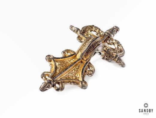
In 2010, locals alerted the Kalmar County Museum that the Sandby Borg ring fort was being looted. The Museum conducted a metal detector survey in order to save any remaining artifacts. They found some amazing items, including jewelry caches containing large gilded brooches. Why would these items be left behind? Because of this mystery, the Museum began excavating Sandby Borg.


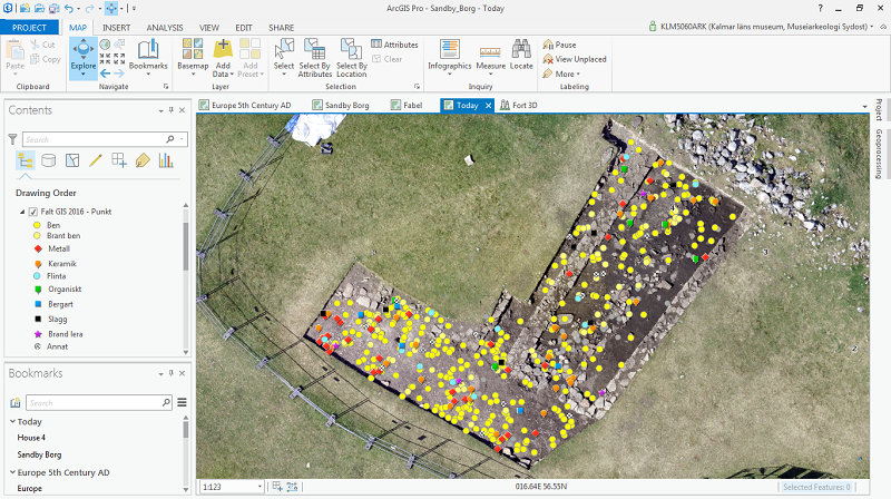
This new basemap allowed the archaeologists to see traces of house foundations within the fort. Raster functions and image classification techniques further enhanced the building foundations and delineated the fort’s ring wall and defensive boulders just outside the wall.
Next, archaeologists excavated one of the dwellings–house 40. They document the artifacts using a workflow developed by the Museum called IDA, Instant field Documentation system and Availability, which utilizes Collector for ArcGIS. “Thanks to Collector we have more efficient data collection, a user friendly interface and high accuracy measurements when combined with the Leica Zeno 20”, said Nilsson.
In house 40 they found food remains – a pile of lamb bones and fish skeletons. It would seem the fort was suddenly deserted, leaving meals unfinished. To their surprise, the archaeologist also found evidence of a mysterious and violent event; they uncovered 6 complete human skeletons. Their osteologist (bone expert) determined that all of them died a violent death, some suffered fatal blows to the head.
In order to unravel the mystery of who they were and what happened to them, the archaeologists needed to find more skeletons in order to perform osteology and DNA analysis. So they called on the amazing Fabel.
Fabel, a black German Shepherd, is trained to find human skeletons, even ones that are 1,500 years old. With a Zeno 20 loaded with Collector for ArcGIS strapped to his back, Fabel sniffs out bones. His handler then tags the spot with a flag as well as hitting a button on the device to digitally mark the spot. While Fabel was not available to attend the Esri User Conference due to his work commitments, the Esri team was able to recognize Fabel as the only certified Arkeologihunden (archaeology dog) making a difference with GIS.

“Going digital is a huge leap for archaeology,” said Gunnarsson. “Esri’s technology reduces our workflow saving us 3 hours per person a day. It changes how research is being conducted and findings reported. Archaeologists can now dig, document, and make their results available in real-time.”
Using ArcGIS 3D capabilities, the team digitally reconstructed the fort including the houses, grass roofs, and defensive wall. Kalmar County Museum has embedded web maps and a 3D web scene on the Sandby Borg website (http://www.sandbyborg.se/ in Swedish and http://www.sandbyborg.se/en/home/ in English) so that visitors can interactively explore the site and follow the project as it advances.

What the archaeologists found through several years of excavations is that around 480 AD Sandby Borg was the site of a massacre so terrifying, that the fort became taboo; no one ever returned; the bodies were never buried; the houses never looted; the farm animals never stolen or released; and the site was never rebuilt upon. These are the mysteries at Sandby Borg.
Gunnarsson explained, “Archaeology is more than the study of the past, it’s the study of the present by using the past; and GIS helps us understand not only what happened in Sandby Borg, but also understand and shape, our actions today.”

