Skip to Content
ArcGIS Drone2Map

ArcGIS Drone2Map

Part of the ArcGIS Reality suite of products

Drone reality mapping on a desktop

Go to pricing
Topography lines in the background, Desktop screen showing volumetric analysis performed on drone collected data, drone flying in the foreground

Robust drone mapping desktop software

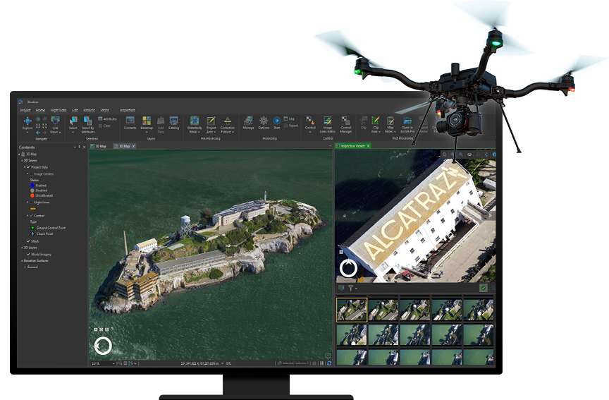
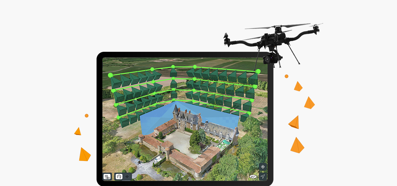
As part of the ArcGIS Reality suite, ArcGIS Drone2Map is the desktop app for your drone mapping needs. Use any modern drone to capture high-resolution imagery where and when you need it. Immediately after the flight in the field, process images on your laptop and perform drone analytics on your natural-color, thermal infrared, or multispectral datasets.

Within the ArcGIS system, Drone2Map provides easy access to a range of tools and capabilities for accurate mapping and geospatial analysis. As a 2D and 3D photogrammetry app, Drone2Map lets you create the outputs you need with a powerful processing engine—including true orthos, 3D point clouds, and textured meshes—and then easily share them with your ArcGIS organization for greater collaboration and awareness.

Download product overview PDF

Robust GIS drone mapping software

Capture reality with your drone

Use any modern drone to capture high-resolution imagery where and when you need it for your GIS drone mapping workflow. Esri recommends the Site Scan Flight for ArcGIS Limited Edition  (LE) application to plan your flight and fly your drone, but other flight apps and nearly all drones are supported for processing in Drone2Map.

iPad screen showing drone flight plan with terrain follow feature enabled

Work in the office or in the field

As Drone2Map is a desktop app, you can download Drone2Map on your machine and process images immediately after a flight instead of waiting for an internet connection. After returning to the office, you can generate high-quality imagery products to use in your GIS or publish to share with others.

Construction worker holding laptop at a construction site with bulldozer in background

Drone analytics

Use the built-in capabilities of Drone2Map to visualize your natural-color, thermal infrared, or multispectral datasets. Perform 2D and 3D measurements—including distances and areas, terrain profiles and volumetric calculations, or spectral profiles—to analyze your drone data quickly.

Integrated across the ArcGIS system

As part of the ArcGIS system, Drone2Map provides access to a range of tools and capabilities for accurate mapping and geospatial analysis. Projects can be opened easily in ArcGIS Pro for integrated management, and imagery data products can be published in ArcGIS Online or ArcGIS Enterprise, including full support for multispectral, thermal, and elevation datasets.

Desktop screen showing ArcGIS Pro performing additional analysis

2D ortho mapping products

ArcGIS Drone2Map enables users to easily process overlapping nadir images to create accurate 2D true orthos, orthomosaics, digital surface models (DSMs), and digital terrain models (DTMs). These outputs, referred to as ortho mapping products, integrate seamlessly into ArcGIS Online, ArcGIS Enterprise, or ArcGIS Pro and provide great value due to their timeliness, resolution, and accuracy.

3 images stacked showing different analysis views of an excavation site

3D reality mapping products

Create high quality 3D reality mapping products such as point clouds and photo-realistic textured meshes from nadir and oblique images. Drone2Map also enables the creation of DSM orthomosaics with sharp building edges and all aboveground features in their correct horizontal location.

2 point cloud images of a city view using different color parameters

How it works

Capture

Collect drone data using Site Scan Flight LE or any third-party drone data collection app.

Download and process

After the completed flight, create a project to download your drone imagery. Add ground control and automatically process to create 2D and 3D outputs.

Visualize and analyze

View 2D and 3D outputs. Make measurements, track changes, and perform other analyses within Drone2Map.

Perform advanced analysis

Open your project easily in ArcGIS Pro to use a range of tools such as advanced spatial, temporal, and spectral analysis and data management.

Share

Share your imagery outputs within your organization or with the public as feature layers, web maps, imagery layers, and more.

Case Study

Angola, Africa

Angola, an African nation, modernized land administration with GIS and cadastre management, improving security and legal certainty.

Read the case study

Site Scan Flight for ArcGIS Limited Edition iPad application

Built for ArcGIS Drone2Map users, Site Scan Flight for ArcGIS Limited Edition allows you to easily capture rich imagery using advanced drone flights. Capture complex sites using the Terrain Follow tool to ensure that a constant height aboveground is maintained, and Vertical or Perimeter Scan flight modes enable data collection around structures to create detailed 3D models. With built-in tools to execute repeatable, autonomous drone flights, choose the flight mode tailored to the specific site; obtain airspace authorizations; and display content from ArcGIS Online, like boundaries or obstacles, to help plan the mission.

Download the app
: iPad screen showing flight plan around a castle

ArcGIS Reality product suite

Explore the software applications that are a part of ArcGIS Reality. Find the reality mapping software that fits the size of your projects and the sensors you work with.

ArcGIS Reality for ArcGIS Pro

ArcGIS Reality for ArcGIS Pro

Use this extension to generate large-scale true DSMs, true orthos, DSM meshes, point clouds, and 3D meshes from satellite, aerial, and drone imagery.

Explore the extension
ArcGIS Reality Studio

ArcGIS Reality Studio

Explore this scalable, stand-alone application for citywide and countrywide reality mapping to create an important piece of 3D digital twins.

Explore ArcGIS Reality Studio
Site Scan for ArcGIS

Site Scan for ArcGIS

Process large volumes of drone imagery faster with cloud-based data processing and create 2D and 3D maps and models that you can quickly share across your organization.

Explore Site Scan for ArcGIS

ArcGIS Reality and digital twins

Digital twins are representations of real-world objects and their processes and relationships. With ArcGIS Reality, users create highly accurate 3D meshes, true orthos, and point clouds to use as an important piece when developing 3D digital twins of social, natural, and built environments. Learn more about Esri’s 3D capabilities and how they relate to a comprehensive digital twin.

Learn more about digital twins
3D mesh of a city showing buildings, roads, and green land overlayed with underground data and street data layers
person-administrator-64

Contact sales


Talk to someone on our sales team

1-800-447-9778

7:00 a.m.–5:00 p.m., Monday through Friday (PT)

Outside the US?