ArcGIS Tracker is a mobile solution that enables organizations to capture the tracks of mobile users, monitor where they are, and analyze where they have been. Tracker includes a mobile app for iOS and Android devices that efficiently runs in the background to capture location tracks. It also includes a Track Viewer web app that administrators can use to view tracks.
Tracker recently updated on both the iOS and Android platforms and there a couple of key new enhancements worth mentioning.
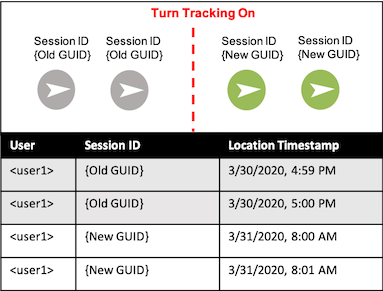
Unique ID
Tracker now auto-generates a unique ID for each tracking session. When you flick the switch to turn on tracking, a new GUID value will be written into the Session ID field. This makes it easier to analyze multiple tracks made by one mobile user.
For example, if you are conducting a gas leak survey in an assigned section of pipeline, turn tracking on at 8:00 AM and a new GUID value will be written to each subsequent track point. When you are finished with the leak survey, turn tracking off. All tracks between 8:00 AM and when you finished the gas leak survey will have the same Session ID value.
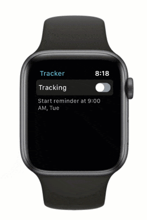
Apple Watch App
A companion watchOS app is now available to pair with iOS devices. You can start and stop tracking directly from your Apple Watch without having to take your phone out of your pocket. From the watchOS app you can view your schedule as well.
We’ve added Tracker as a watch face complication so that you can view tracking status from any watch face or open the app directly from the complication to change your status.
In addition to the updates mentioned above, we’ve made a number of performance and stability improvements to the mobile apps and to the Track Viewer web app as well.
What’s Coming Next
There’s lots to new functionality filling up the product pipeline for Tracker. We’re currently shaping a few key enhancement requests we’ve heard from you. Here is a sampling:
- Providing more control over the scheduling experience
- Extending the location tracking schema
- Providing a privacy geofencing experience for mobile users
- Adding support for indoor positioning
Please let us know what you’d like to see next in Tracker. Submit your ideas to the ArcGIS Ideas site.


I’ve seen some documentation that suggests Tracker is able to utilise an external, high accuracy GPS to record location tracks. Is this correct? If so, how do I configure the Tracker Mobile App to enable this? I have had a look at the settings available in the ‘Profile’ section of Tracker but couldn’t find any settings that relate to enabling an external GPS.
Many thanks,
Scott
Hey Scott, We haven’t added any functionality to directly support bluetooth GPS receivers but we are considering this for ArcGIS Field Maps. When you connect a bluetooth GPS receiver to your iOS or Android device it now becomes the location provider so you are getting the better quality GPS positions in Tracker – you just don’t know you are. That’s because we are reading the accuracy information from the location API provided by Apple or Google and it doesn’t correct accuracy information (you may be getting 1m accuracy but it will report 5m). If you set up a “Location Provider”… Read more »
Thanks, Jeff. That clears things up for me. I was concerned that we might be collecting features using the positions from the external GPS but collecting the track log using the internal GPS.