Hear ye, hear ye! Let it be proclaimed from the highest datum to the humblest feature class—a new release hath arrived, and first among its gifts:
The ArcGIS Topographic Mapping server extension is now supported in ArcGIS Enterprise deployments on Linux.
This means that Linux users also have the extension’s server object extension (SOE), plus the Map Production System (MPS) and Topographic Production Manager (TPM) web apps at their disposal.
Other exciting updates to the ArcGIS Topographic Mapping extension in ArcGIS Pro 3.7 and ArcGIS Enterprise 12.1 include accessibility improvements and developer enhancements, which trickle into the web apps alongside other new app functionalities.
Accessibility improvements
In both ArcGIS Pro and ArcGIS Enterprise, the May release of Topographic Mapping includes fixes to better align with the standards set by Web Content Accessibility Guidelines (WCAG).
This means improved screen reader narration and keyboard accessibility across Topographic Mapping panes and layout elements. This also includes the MPS and TPM web apps.
For a complete list of accessibility improvements, visit Esri Community.
Developers
The extension’s Topographic Production service is enhanced with new parameters on the REST API query operation. Aside from new ways to filter the list of jobs, these new parameters allow for paginated subsets when the list of jobs returned is large. This enhancement is reflected in the TPM app.
On the topographic production workflows front and ArcGIS Workflow Manager integration, when a workflow is defined, the task group used now allows for dependencies, assignment, and the automatic creation of another task group job when it is finished running.
For more context, the JSON that comprises task groups support the following new objects:
dependencies—pause a job until a different job reaches a specific statustaskGroup—assign a job to someone when it is created or if it failspostJobActions—automatically create another job when one finishes
TPM app
As mentioned above, thanks to the enhancements to the query operation, the list of jobs in the TPM app are now displayed in manageable chunks with page numbers under the list to flip through subsets of jobs rather than scrolling one list.
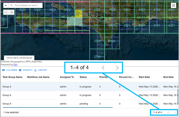
You can now click a job on the map in the app. This highlights its area of interest (AOI) and selects its record in the table to bring up the job’s details in a new Job Details pane. When a job’s details are updated, you can see the updates using the new pane’s included refresh button. This refresh button is also available on the list of jobs.
Previous versions of the TPM app displayed dates and times in UTC (Coordinated Universal Time)—a universal baseline commonly used by servers and databases. While great for consistency on the back end, UTC doesn’t account for where you are located while using the app. For example, a deadline set for May 15 at 5:00 PM in California would appear as May 16 at 12:00 AM in UTC—the next day. This could lead to dates looking wrong at a glance, phase dates can appear to fall outside of a project’s date range when they actually don’t, and general confusion among team members working across different time zones. With this release, the TPM app now converts all timestamps to your local time zone before displaying them to help match what you see with what you mean. Phase dates that genuinely fall outside of a project’s date range are also now properly flagged as errors, making scheduling conflicts easier to catch.
Topographic workflows
The Workflow Manager app allows administrators to create custom searches. These searches can be shared with workflow item users or groups. With the Workflow Manager-Topographic Mapping integration, the configuration file included with the Topographic Mapping product data files that you import when you deploy topographic production workflows also supports shared searches now.
Generalization
Generalization updates impact the Topographic Mapping extension in both ArcGIS Pro and ArcGIS Enterprise. Detailed guidance on generalization is included in PDFs that are installed alongside the extension’s product files for ArcGIS Pro and ArcGIS Enterprise.
ArcGIS Pro
The ArcGIS Pro enhancements involve a geoprocessing tool and the generalization framework.
Geoprocessing
The Thin Hydrology Lines tool has been refined to address issues that were leading to unintended results. The fix ensures that features with a Hierarchy value of 0 are no longer incorrectly set to turn visibility off during processing.
Additionally, improvements to the Minimum Spacing parameter logic allow the tool to reduce visual clutter more effectively by removing features that are within the specified spacing distance and trending similarly, even when they exceed the minimum length threshold.
Framework
The models and scripts mentioned here are included in the Topographic Mapping product files.
- Enhanced feature aggregation control—The Aggregate By Fields tool now includes a Non-Orthogonal parameter, allowing users to optionally disable orthogonal shape preservation. By default, orthogonal geometry is preserved for structured outputs, while the new option enables more natural feature shapes when needed.
- New attribute-driven elimination capability—The Eliminate by Field Value script tool has been added to the General Polygons model, providing greater flexibility to remove features based on attribute values.
- Improved linear feature consolidation—An optional merge capability has been added to linear feature workflows, enabling features to be merged based on configurable tolerances. This helps reduce fragmentation in generalized outputs such as rail networks.
- Improved workflow flexibility for feature removal—General models now include logic to remove features marked as Remove Type in the rule file. This enables workflows where features can be transformed or reclassified earlier in processing and reliably removed in later stages.
- Enhanced handling of linear feature continuity—Updates to the SOE models introduce a cleanup step that removes unnecessary intermediate splits created during earlier processing, improving the continuity of features such as coastlines.
- Improved stability for concurrent processing—Addressed an issue that could cause errors when running multiple generalization processes on the same machine, improving reliability in parallel processing environments.
- Improved representation of built-up areas (BUAs)—Structure models now support an optional barrier feature class (STRUCTURE_BUABARRIER_L), allowing built-up areas to align with real-world constraints such as roads. This improves spatial accuracy and cartographic realism in urban areas.
ArcGIS Enterprise
- Automated generalization and update workflows—At ArcGIS Enterprise 12.1, the Topographic Mapping Workflow Framework has been expanded to include fully automated generalization and update workflows. These workflows run autonomously by default, requiring user interaction only to resolve errors or exceptions.
- Support for persistent multi-scale data maintenance—New workflows enable continuous generalization and maintenance of persisted multi-scale enterprise geodatabases, keeping derived datasets up to date as source data evolves.
- Automated cartographic product generation—The framework now supports automated generation of cartographic products at destination scales, streamlining the production pipeline from data updates to final map outputs.
At a glance
The following table summarizes the impact of the enhancements with details on how items were performed before and after this release:
| Prior to this release | ArcGIS Enterprise 12.1 |
|---|---|
| The search pane had limited filtering options and no support for pagination, making large result sets difficult to manage. | The search pane in the TPM app now supports the query REST API operation filter capabilities and pagination. |
| To find a job’s record in the attribute table, you had to manually locate and select it — no map-driven selection was available. | You can click a job directly on the map to select its record in the corresponding attribute table in the TPM web app. |
| There was no dedicated area in the TPM app to view detailed information about a selected job. | A new Job Details pane provides at-a-glance details about selected jobs directly in the TPM app and you can refresh a job’s details. |
| The list of jobs was periodically updated at a regular interval specified during configuration. | You can manually refresh the list of jobs in the TPM app any time. |
| Searches in topographic production workflows were standalone and could not be shared. | Shared searches are now included in the topographic production workflow configuration file (.wmc), making reuse across teams seamless. |
| Dates and times in the TPM app were displayed in UTC (Coordinated Universal Time), which could make deadlines appear to fall on the wrong day depending on your time zone. This also meant phase dates could be incorrectly flagged — or not flagged at all — when compared against a project’s date range. | Start and end dates in the TPM app are now displayed in your local time zone, so deadlines and schedules accurately reflect when things are actually due. Phase dates that fall outside a project’s date range are also flagged as errors, making it easier to catch scheduling conflicts at a glance. |
| The schema version of the topographic server geodatabase did not necessarily align with the ArcGIS Enterprise release version, which could cause confusion. | Going forward, the schema version of the topographic server geodatabase matches the version of ArcGIS Enterprise it was released with. |
| Orthogonal geometry was always preserved during aggregation, with no option to adjust output shape. | A new Non-Orthogonal option allows users to generate more natural feature shapes when needed, while preserving orthogonal geometry by default. |
| Feature removal after transformation was limited and not consistently applied across workflows. | Features marked as Remove Type are now consistently removed during processing, enabling more flexible transformation and cleanup workflows. |
| Intermediate splits introduced during processing could persist in output data, reducing feature continuity. | New cleanup logic removes unnecessary intermediate splits, improving continuity of features such as coastlines. |
| Built-up areas (BUAs) did not align well with real-world constraints such as roads. | BUAs can now snap to barrier features such as roads, improving spatial accuracy and cartographic realism. |
| Linear features could remain fragmented after generalization and often required manual cleanup. | Optional merge capabilities reduce fragmentation by combining linear features using configurable tolerances. |
| Generalization workflows were primarily run manually in ArcGIS Pro. | Fully automated generalization workflows run in ArcGIS Enterprise, requiring user interaction only to resolve errors. |
| Updating derived datasets required manual reprocessing. | Persisted multi-scale datasets can now be continuously updated through automated workflows. |
| Cartographic products were generated through manual or semi-automated workflows. | Cartographic products can now be generated automatically at target scales as part of end-to-end workflows. |
Lastly, a minor change at this release that doesn’t impact functionality is that the schema version of the topographic server geodatabase now aligns with the version of Enterprise it was released with to prevent confusion.
For more information about the ArcGIS Topographic Mapping product visit the product overview page, or for guidance on using the extension visit the help documentation, or join the global community of Topographic Mapping users to find solutions, share ideas, and collaborate.
We hope that this blog post has been informative, and these enhancements help with your work, thank you for reading!

Commenting is not enabled for this article.