Enterprise-grade AI applications depend on more than cutting-edge models or model size. They need high-quality, authoritative data to improve accuracy, reduce bias, and limit hallucinations. ArcGIS Enterprise securely serves your organization’s authoritative data from a wide range of sources, along with built-in and custom geoprocessing tools. MCP for ArcGIS Enterprise connects these data sources and capabilities to your AI application, enabling geospatial reasoning while honoring your organization’s trust, privacy, and security standards. Let’s dive in!
What is Model Context Protocol (MCP)?
Before exploring MCP for ArcGIS Enterprise, let’s review the underlying technology. The Model Context Protocol (MCP) is an open-source standard for connecting AI applications and large language models (LLMs) to external data sources, tools, and workflows. On their own, LLMs cannot reliably connect to enterprise systems. Before MCP, integrations relied on bespoke connectors between an AI application and a target system. These connectors could be fragile and require considerable upkeep, especially as models were rapidly introduced and retired.
MCP was created to address this challenge. Think of it as a USB-C connector between an AI application and external systems. MCP provides a directory of tools, defined input and output schemas, and prompts to help applications use those tools effectively. This standard simplifies integration and reduces upkeep once configured. How does it work with ArcGIS Enterprise?
MCP for ArcGIS Enterprise
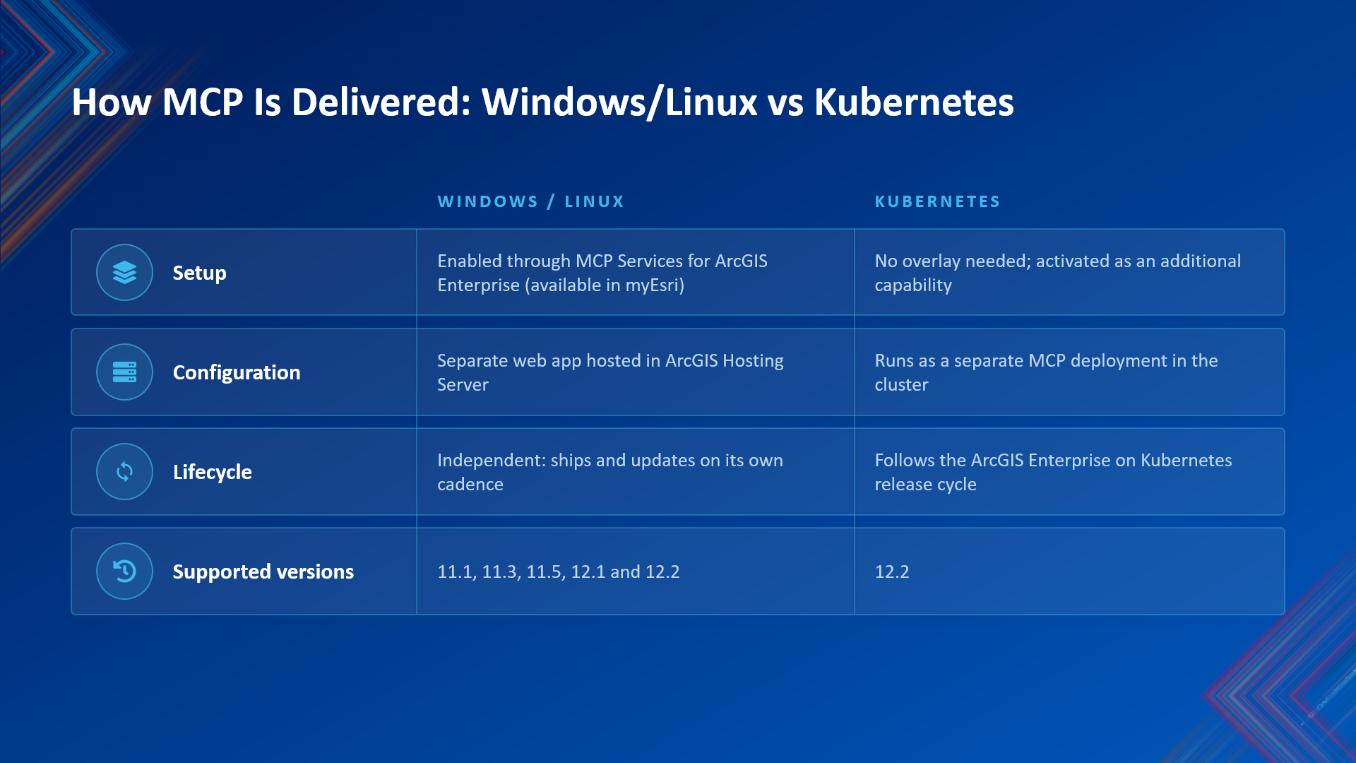
MCP for ArcGIS Enterprise is an Esri-developed integration layer that allows AI applications to discover and invoke ArcGIS capabilities. On Windows and Linux, these capabilities are enabled by a separate installed component: MCP Services for ArcGIS Enterprise. This component is unique with an independent release lifecycle and versioning scheme. At release, MCP Services for ArcGIS Enterprise 2026.0 will support ArcGIS Enterprise 11.1, 11.3, 11.5, 12.1, and 12.2 and will be available via My Esri to all eligible customers with maintenance. When a new version becomes available, the previous version will be retired. For details, see the MCP for ArcGIS Enterprise product lifecycle.
On Kubernetes, MCP for ArcGIS Enterprise is included in the base installation images for ArcGIS Enterprise 12.2 and later. MCP updates follow the ArcGIS Enterprise on Kubernetes lifecycle.
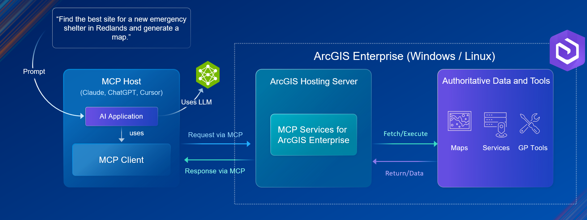
An MCP connection has several components. The user interacts with an AI application, or host, that contains an MCP client. The client connects to an MCP server, which exposes selected ArcGIS Enterprise capabilities as tools with defined descriptions and schemas. When a request requires geospatial reasoning, the AI application selects a tool. ArcGIS Enterprise performs the GIS operation and returns the result, which the AI interprets and presents. Users interact with the AI application while ArcGIS Enterprise performs the authoritative GIS work.
MCP for ArcGIS Enterprise exposes a focused set of capabilities, not everything ArcGIS Enterprise can do. The initial tools support content discovery, data queries, map generation, location services, and geoprocessing. This scope enables AI-assisted workflows while helping protect authoritative systems of record. Organizations can extend these capabilities by exposing published geoprocessing services or developing custom MCP tools.
Install and Configure MCP for ArcGIS Enterprise
On Windows and Linux, MCP Services for ArcGIS Enterprise is installed on the ArcGIS Hosting Server and runs as a separate web application with an independent release lifecycle. On Kubernetes, MCP is included with ArcGIS Enterprise 12.2 and runs as a separate deployment within the cluster; no separate installation is required.
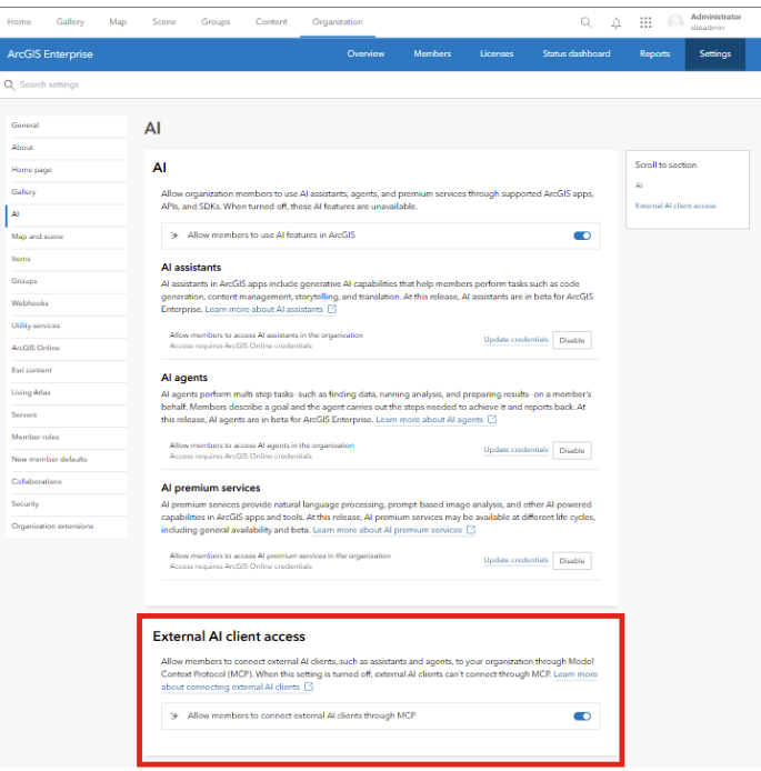
In ArcGIS Enterprise 12.2, external AI client access is disabled by default. An administrator must enable it under Organization settings > AI before an external AI application can access a default or custom catalog. This organization-wide control applies even if the authenticated user has permission to access the catalog and its content.
Connect an AI application to ArcGIS Enterprise via MCP
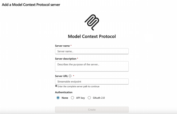
Once MCP for ArcGIS Enterprise is configured, you can connect to the AI application of your choice. All connections require authentication. This release supports three authentication methods: API key, token, and manual authentication through OAuth 2.0.
MCP-compatible AI applications let users register an MCP catalog endpoint, such as server yourdomainhere/platform/mcp. Requirements vary by application, but you generally need the catalog endpoint and an authentication method. After registration, the application displays the available MCP tools.
MCP Tools
MCP for ArcGIS Enterprise includes a built-in catalog of tools. More than exposed REST endpoints, each tool provides the information an AI application needs to complete a request: a name, description, input and response schemas, and purpose. The 2026.0 release covers four broad capabilities:
- Content and data — search ArcGIS Enterprise for items, describe items and layers, and query records.
- Mapping — render static map images for screen, print, or vector editing.
- Location services — find address candidates, reverse-geocode, and solve routes between locations.
- Geoprocessing — invoke GP tasks, retrieve GP task definitions, and check the status of asynchronous jobs.
Eleven MCP tools are included in this release alongside ArcGIS Enterprise 12.2. Administrators can also expose custom geoprocessing (GP) tools through MCP, allowing agents to use them without developing custom MCP tools. Lets take a deeper look at each tool, and its purpose.
- Search Content: The Search Content tool lets an AI client discover ArcGIS Portal items in your ArcGIS Enterprise organization.
- Search Portal Content Passthrough Instructions: This tool provides instructions for performing search_portal_content invocations that require a passthrough approach. The tool is consulted by an agent that has already determined a structured search cannot satisfy the request, so that the agent can build a valid raw query string before calling.
- Describe Item: This tool Returns full information about a single Enterprise portal item.
- Describe Layer: This tool returns the metadata of a single layer or table inside a feature service or map service.
- Query Data: This tool queries a feature layer or table for records or aggregations.
- Get Map Image: This tool renders a static map image from an ArcGIS MapServer.
- Find Address Candidates: This tool forward-geocodes an address, place name, postal code, or point of interest into one or more candidate locations using the ArcGIS World Geocoding Service or a portal-configured geocoder.
- Reverse Geocode: This tool converts a longitude/latitude coordinate to the nearest street address or place name. It is the opposite of the Find Address Candidates tool.
- Solve Route: This tool solves a simple best-path route between a start and end location, with optional intermediate stops and a chosen travel mode such as driving, walking, or trucking.
- Get GP Task Definition: This tool fetches the description and input/output JSON Schemas of a single geoprocessing task on a GPServer.
- Get GP Task Job Status: This tool fetches the current status of an asynchronous geoprocessing job by its job ID.
In addition to these eleven tools, you can expose custom Geoprocessing (GP) tasks as custom MCP tools without needing to use the ArcGIS Enterprise MCP developer resources. Any GP task published through a Geoprocessing Service (including webtools created from an ArcGIS Notebook) can be tagged for use by an AI application by following the data preparation steps below. This allows you to make MCP for ArcGIS Enterprise bespoke to your use cases beyond what is included in the default tool kit. But how do we ensure that you keep your MCP tools organized if you are leveraging several connections for different AI applications? This is where catalogs come into play.
Catalogs organize the tools available to AI applications and agents. In ArcGIS Enterprise 12.1 (Windows and Linux) and earlier supported versions, a default catalog exposes built-in and registered custom tools through a common endpoint. ArcGIS Enterprise 12.2 adds custom catalogs: purpose-built collections of selected default and custom tools for specific workflows. Each custom catalog is an MCP Catalog item in ArcGIS Enterprise, has its own endpoint, and can be shared with specific users or groups. The default endpoint is:
https://<domain>/<context>/mcp/default
In ArcGIS Enterprise 12.2 (Windows, Linux, Kubernetes) and later, custom catalog endpoints use the catalog’s ArcGIS Enterprise portal item ID:
https://<domain>/<context>/mcp/<item-id>
Catalogs give AI applications a focused set of tools and administrators greater control over how those tools are organized and made available. After authenticating to an endpoint, the application discovers the tools exposed through that catalog.
Data Preparation
An AI application’s ability to use ArcGIS Enterprise resources depends on well-prepared, well-documented content. Administrators should focus on two areas to make data MCP-ready: tagging and metadata.
First, tagging. Items must carry the “mcp” tag to appear in results from the search portal content MCP tool. However, the tag is not an access control: untagged items may still be accessible through other means. Use sharing settings and the authenticated user’s permissions to control the AI application’s access.
Next, metadata. Tagging helps the AI application discover content; complete metadata helps it determine what an item contains and whether it fits the request. Clear, accurate titles, snippets, descriptions, and tags help the agent select appropriate content. An MCP-ready description should cover:
- Overview — one or two sentences explaining what the dataset is and its purpose.
- Contents — the layers, tables, or bands the item exposes, with key fields or attributes. This helps an agent assess whether the item can answer a question before calling other tools.
- Geographic coverage — the area covered and the coordinate system, so the agent can match location-based requests.
- Use cases — the questions or analyses the data supports, expressed in language users are likely to use.
ArcGIS Enterprise 12.2 includes the Item Details Assistant in beta. This assistant can help you improve the quality of the information you store about your items, which, in turn, helps other users find, understand, and use the items. The assistant provides suggestions for the detail values. You can use each suggestion provided by the assistant as is or use it as a starting place that you modify it to suit your needs. To learn more about the item details assistant and its requirements refer to our documentation.
An MCP-ready item should:
- Carry the “mcp” tag.
- Have a clear, descriptive title and snippet.
- Have a description covering its overview, contents and key fields, geographic coverage, and use cases.
- Be shared with the intended users under your organization’s permission rules.
Security and Trust
MCP for ArcGIS Enterprise gives AI applications geospatial capabilities and access to your organization’s authoritative data. It uses established authentication methods and organization-level AI controls to secure that access. After authentication, an application can access only the content available to the user whose credentials it uses. This model keeps access governed by your organization’s permissions, with people responsible for how tools and content are made available.
The tools in this release reflect Esri’s commitment to protecting authoritative systems of record. They focus on content and data discovery, mapping, location services, and geoprocessing, enabling AI applications to use existing resources while helping preserve their integrity. To help shape future releases, share feedback through enhancement requests through technical support or through ArcGIS Ideas in the Esri Community.
MCP Extensibility
MCP for ArcGIS Enterprise includes 11 built-in tools and supports custom geoprocessing tools enabled for MCP. If your AI workflow needs additional capabilities, the ArcGIS Enterprise MCP developer resources lets you build, test, and validate custom MCP tools.
Extensibility separates development from production administration. Developers use ArcGIS Enterprise MCP developer resources to build and test tools locally, validate them, and package them for deployment. The initial toolkit supports Java and includes Maven plugins, archetypes, project templates, validation, and packaging capabilities. Developers then hand the completed package to an ArcGIS Enterprise administrator.
Administrators register and manage custom tools, add them to the appropriate catalog, and share the catalog with intended users or groups. In ArcGIS Enterprise 12.2, tools are managed through ArcGIS Enterprise Admin APIs and custom catalogs through the ArcGIS Enterprise portal. Earlier supported versions, from ArcGIS Enterprise 11.1, 11.3, 11.5, and 12.1, use the MCP web application’s Admin APIs and expose registered tools through the default catalog.
Closing Takeaway
MCP for ArcGIS Enterprise connects AI applications to authoritative geospatial data and GIS tools under your organization’s access controls. Start with well-documented content and a focused catalog, then extend the available tools as your workflows evolve. If you are excited about the MCP capabilities coming into ArcGIS Enterprise, or would like to leave some feedback, please engage with us in the ArcGIS Enterprise board on Esri Community!


Commenting is not enabled for this article.