Engagement Matters – Part 3
This article is the third part of a four part series on collaboration and engagement.
Part 1A Hub for
|
Part 2Empowering
|
Part 3Sustaining
|
Part 4Building
|
Click on any of the articles above to jump forward or backward
Collaboration is a commitment that governments make to their various community groups. It’s an invitation to engage and solve problems that neither group can fully resolve on its own. Sometimes it’s the government that has resources and the community group has a better understanding of how to resolve a problem. Other times it’s the government that has many ways to resolve an issue but needs help selecting the best option from community groups that understand citizens’ diverse needs. Either way, the collaboration between government and community groups needs to be cultivated and sustained over time. Challenges evolve, new officials are elected, priorities change, new problems emerge, technology improves, and so on. These predictable changes in organizations can easily crumble a collaboration effort if it isn’t built on a solid foundation to begin with.
Different levels of engagement exist along a spectrum. Selecting which one works best for a particular issue depends largely on how much involvement a government needs or wants from the community.

The level of engagement applied to a particular issue can also change over time. Take for example a sudden worsening of the traffic on Main Street in a fictional city. As a first step, the city commissions a traffic study to explore the source of the problem and then publishes the study report to the city’s website. While this might seem helpful, simply sharing the report does very little to engage a wide range of citizens in the community. Over time and as the city continues to explore the traffic issue, it creates an interactive story that frames the traffic issue using data, maps, charts, and even videos. These data-driven activities are meant to help more people understand the nature of the traffic issue and to build trust that the city is working to solve the problem. The city also begins surveying drivers on Main Street to help understand their driving habits and seek input on potential solutions.
The highest form of engagement is collaboration where the city views the community groups as partners critical to solving the traffic problem. Collaboration depends on the prior engagement steps which have helped build a foundation of trust and transparency. When a government collaborates with a community group, it is based on a mutual understanding of an issue and includes the expectation that both government and community group must work together to solve the problem.
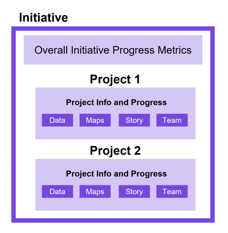
Tracking progress toward solving a problem is especially important when a government and community group are partnering together. Both need to show the progress that’s being made and both need to help build the narrative that the public will see. Initiatives help organize the content – data, maps, charts, stories – and make it easy to find and understand. Initiatives also give specific users in the community group the privileges to help build this content, add more content, and even organize content further.
In our example from earlier, the city has created an initiative that houses all of the content about the traffic issue on Main Street. Yet, like most issues governments face, this traffic problem can’t be solved with a single project. The plan is to break the problem into more manageable – and trackable – projects like adding a bike lane, changing road striping, and adjusting traffic signals. The city is collaborating with the community group to help encourage the use of the new bike lane and to explain the changes to road striping and signal timing to drivers. The community group is helping to communicate these projects and also build narratives that will resonate with the community group’s audience. But how does the city and the community group collaborate on all of this work? The answer is simple: through Projects and Teams.

Projects help organize the data and narrative around a specific task, say for example the creation of bike lanes on Main Street. The city needs to design the new bike lane on top of the existing roadway, secure funding, do the work, then track the change in traffic afterwards. The Project helps organize this information so that the community group can track and respond to different stages in the project. It also helps community group members add their own content or enhance the city’s content to better communicate with citizens.
Taken a step further, members of the community group can be organized into Teams. These teams of community group members can have a clearly defined set of projects to work on. In this case, maybe there’s a specific team dedicated to surveying the impact the new bike lane is making. Through the Team, the data that the community group collects flows into the Project and can be used internally within the city to make adjustments or recommend more changes over time.
Initiatives, Projects, and Teams help governments and community groups collaborate in a way that is transparent and sustainable. These frameworks make information easy to understand between both groups which helps reinforce trust and makes long-term collaboration sustainable. Ultimately, this deep collaboration benefits the most important group of all: citizens.


Article Discussion: