ArcGIS Indoors enables your organization to build an indoor geographic information system (GIS) and makes the power of indoor mapping, space planning, and navigation available to everyone. Key patterns of use include asset management, space management, safety and security, and occupant and visitor experiences.
Discover the latest, including the redesigned Indoors Mobile, enhanced focused Indoors web apps, and Indoors Pro enhancements in the recent releases of ArcGIS Indoors.
ArcGIS Indoors for ArcGIS Pro 3.5
The latest release of ArcGIS Indoors Pro includes updates to tools for additional configuration options and improved outputs, including enhancements to the process of creating floor plans from point clouds and generating indoor routable networks. Additional productivity improvements were also added, including a redesigned floor filter that provides new filtering options and auto-population of critical indoor attributes when making edits in floor-aware maps.
Improved point cloud to floorplans tool
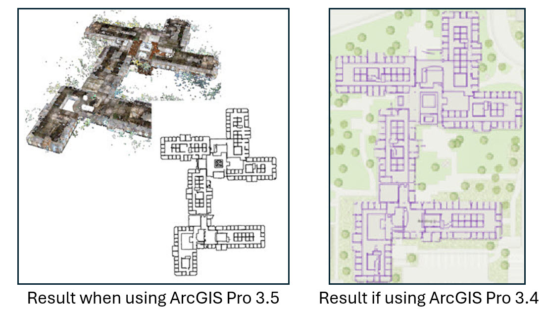
ArcGIS Pro 3.4 included the initial release of the Point Cloud To Floorplan geoprocessing tool, providing the ability to take a point cloud created from a building scan, generate vector linework for a floor plan and create features in an Indoors model for use in floor-aware maps and apps. This is helpful if CAD or BIM files aren’t available for a building, or no longer accurately reflect the interior space, for example if significant renovations has occurred.
The latest release of ArcGIS Pro includes enhancements to the Point Cloud To Floorplan geoprocessing tool to help minimize post-processing steps for linework optimization. This includes a new Simplify Lines option that better connects, partitions, and straightens polylines, the represent indoors walls and features, as well as reducing unwanted artifacts. These are things that can occur because of furniture, wall fixtures, windows, and so on.
The tool allows you to define elevation values to use when creating floorplan polylines. This allows you to define a specific floor in a multi-floor building scan, as well as to filter elevations on a specific floor to avoid vertical regions with furniture, wall fixtures, HVAC systems, windows, and other features that could cause additional linework that is not desirable for floorplan creation. At ArcGIS Pro 3.5, the tool also includes a new option to create an output raster representing the slice of the point cloud defined in the tool. This can serve as an underlay when evaluating the linework and making any desired updates before creating features in the Indoors model.
Floor-aware feature editing
Floor-aware editing allows GIS professionals to edit floor plans in ArcGIS Pro when floor plans require modification due to construction, outdated or incorrect data, or needing to digitize a floor plan from scratch.
At ArcGIS Pro 3.4 the Create tool was enhanced to automatically populate important Indoors fields, including the Level ID and z-value, as well as the Gross Area for units and a generated ID for units and details when a custom value isn’t provided during creation of new features. At ArcGIS Pro 3.5 this auto-population is extended to additional editing ribbon tools, including Split, Move, Move To, Copy/Paste, and Duplicate Vertical. These new auto-population capabilities help minimize manual requirements for field population and potential introduction of errors, such as when manually adding a Level ID value for a feature that is moved from one building to another.
Auto-population has also been extended to the Pathways and Transitions layers, adding values for fields specific to the indoor network layers such as Level Name From, Level Name To, Vertical Order From, and Vertical Order To.
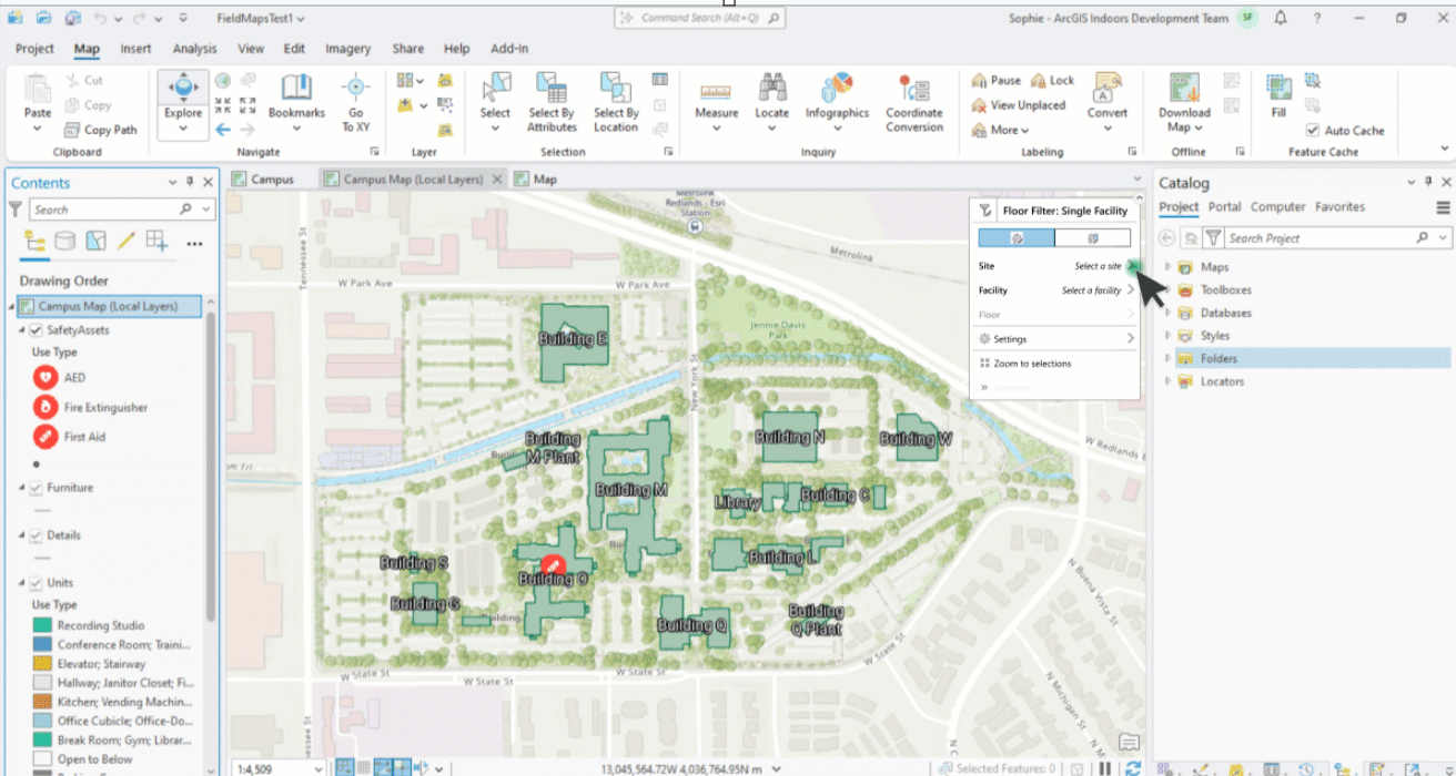
Floor filter redesign
The Floor Filter in ArcGIS Pro has been redesigned to provide new options and improved usability, including the following:
- A multi-facility filtering mode, which filters an entire site or dataset based on vertical order, allowing for visualization of floors with the same vertical order across a campus. This can be especially useful when visualizing connected buildings.
- The option to visualize only the selected building on the map.
- A search bar, allowing for search of sites and facilities across the dataset.
- A zoom to button to quickly pan the map to the active facility.
- An easy-to-use minimized mode, allowing for maximum map space while supporting quick filtering between floors and buildings.
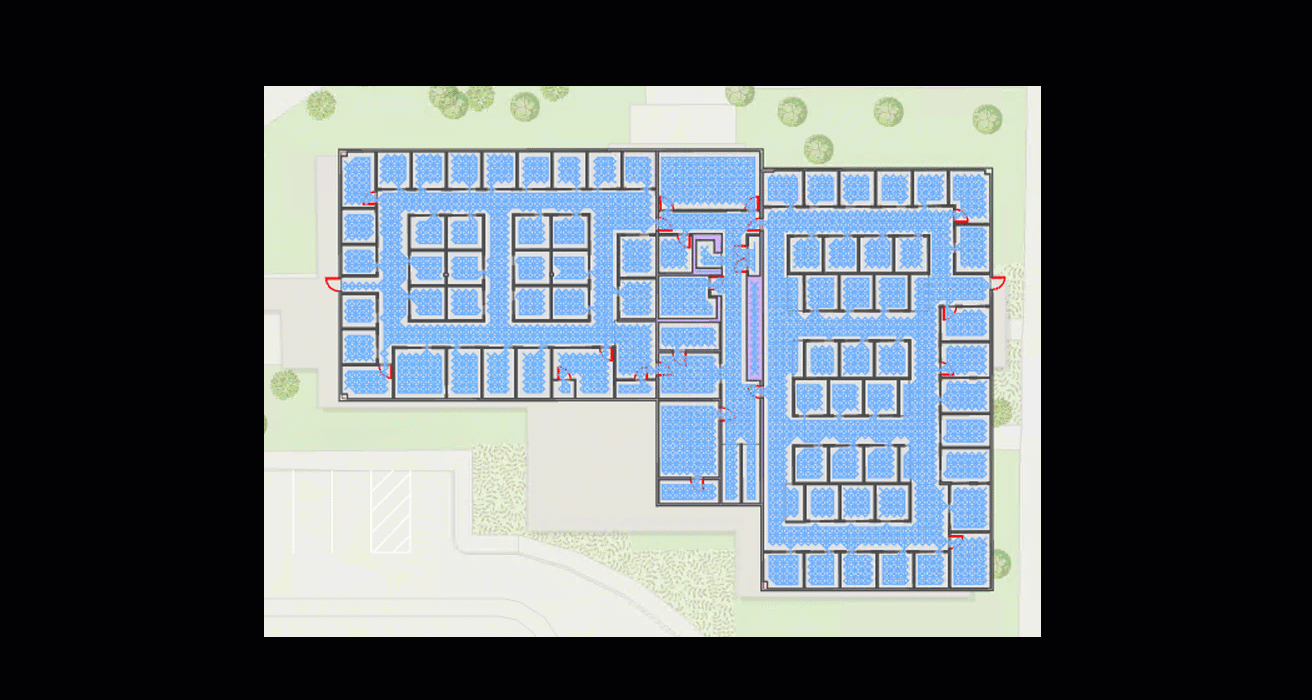
Indoor routable network
The Generate Indoor Network Features tool, which was new at ArcGIS Pro 3.4, now includes a lattice option for the pathway generation method parameter. This option generates pathways based on a lattice algorithm that is well suited for buildings with a consistent orientation and primarily right angles.
In previous versions of ArcGIS Pro, you could generate lattice-based pathways by first running Generate Indoor Pathways and Generate Floor Transitions geoprocessing tools to create an initial network of pathways in the PrelimNetwork dataset, then run Thin Indoor Pathways to create a simplified network of pathways in the Indoor Network dataset. The Generate Indoor Network Features tool combines all these tools in a single, much faster operation, resulting in significant time savings and removing the need for running multiple tools in sequence.
The templates for generating indoor network datasets have been updated to use Python instead of VBScript, which has been deprecated at ArcGIS Pro 3.5.
New redesigned Indoors Mobile (2.0)
The first release of Indoors Mobile was over five years ago, bringing indoor maps in the palm of your hand when it matters the most – when you are on the go or out and about. Whether you are an employee heading for a meeting, a student dashing to the next class, facility worker locating an asset, or even a visitor arriving for the first time at a venue trying to find your way to an appointment, Indoors mobile app has you covered.
In addition to being able to view different floors of the building through indoor maps, Indoors Mobile enables you to get directions inside and between buildings and always know your location with the power of indoor positioning, find the nearest amenities like restrooms and safety assets like emergency exits and fire extinguishers and even reserve workspaces like meeting rooms and office hotels located close to the people you collaborate with while at work.
The brand new, completely redesigned Indoors Mobile 2.0 app has been developed from the ground up with an improved and intuitive user experience as well as brand new capabilities.
Immersive 360-degree photos, automatic turn-by-turn navigation, improved indoor positioning and support for custom branding are some of the exciting new features included in the new app. The user experience for capabilities like workspace reservations, smart launch and even search and explore are enhanced and improved.
Read the dedicated blog for more details including the renaming of the current app to Indoors Mobile Classic.
Indoors Apps Gallery
In the Indoors Apps gallery, you can access all your existing Indoors apps: Indoor Viewer, Space Planner and Floor Plan Editor or create new ones from existing maps. In ArcGIS Online, you can even get started with creating a new floor aware indoor map directly in the web browser. With the click of a button, a new floor-aware web map with layers from the Indoors model and a Floor Plan Editor app is created for you where you can get started creating your floor plans by tracing over an image or use the newly released capability to import floor plans directly from CAD drawings.
Import floor plans from CAD in ArcGIS Online
In addition to creating a new indoor map with the click of a button in ArcGIS Online, you also import floor plans from CAD drawings directly in Floor Plan Editor. This capability helps you extend your indoor GIS team beyond GIS professionals like, members from facilities and operations teams. If you are new to ArcGIS Indoors, this new capability helps you get started creating your floor-aware Indoors maps and Indoors Viewer and Space Planner apps just with the web browser and an ArcGIS account with a Contributor user type. There is no need to learn ArcGIS Pro or setup and maintain ArcGIS Enterprise to get started with indoor GIS.
Business Unit Planning enhancements
In the ArcGIS Enterprise and ArcGIS Online releases last year, we introduced business unit planning through Organization Areas. Organizations are made up of different business units such as School of Engineering or School of Arts at a university for higher education, Administration or Accounting for state and local government offices, and each of them have their specific needs. Organization Areas can be used to plan and review space allocations to various business units and further facilitate workspace area planning by giving space planners insight into which units are available for assignment. More enhancements have been added to Organization Areas including the ability for shared allocations. Typically, spaces like laboratories in a university or conference rooms in an office building are shared amongst more than one business unit. With the new release of ArcGIS Online and Enterprise, percentage-based allocation is now available so more than one organization area can be specified during planning to help with appropriate calculations of space usage.
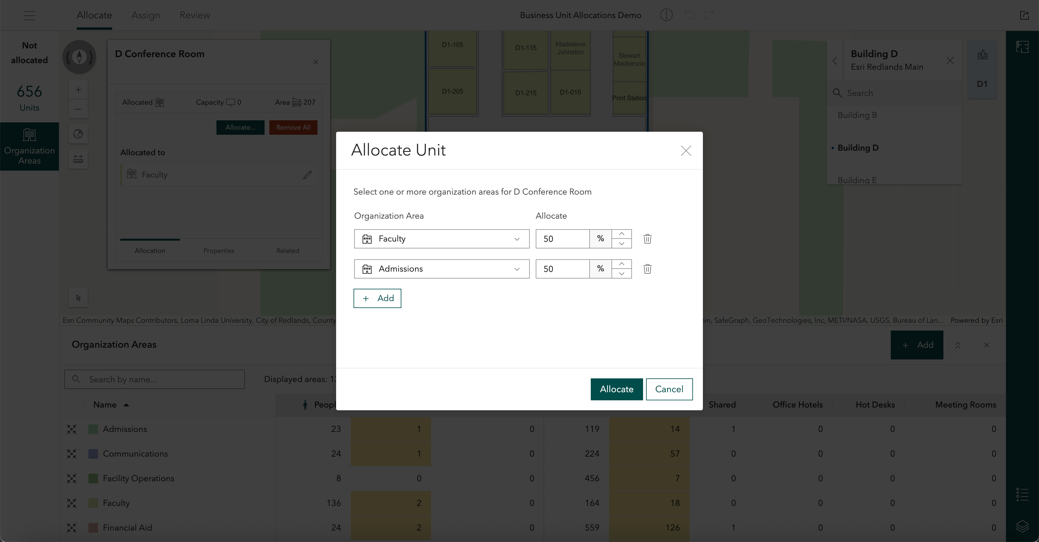
A new field was added to the ArcGIS Indoors information model to support allocating units to more than one organization area in Indoors Space Planner. This field is created by the Create Indoors Database tool or can be added to an existing Indoors model using the Upgrade Indoors Database tool in ArcGIS Pro.
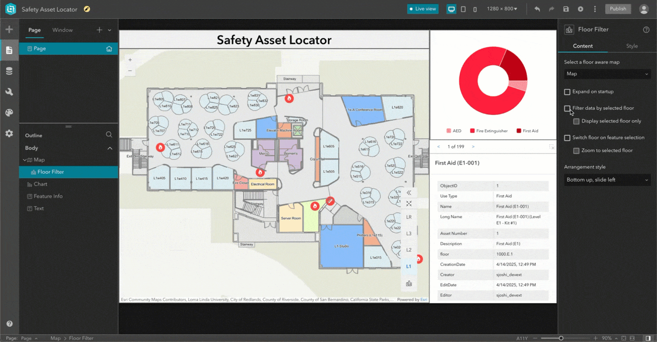
Floor awareness enhancements in ArcGIS Experience Builder
The ability to filter a map to a specific floor in a building has been available in the Floor Filter widget in Experience Builder for a few releases now. In ArcGIS Enterprise 11.5, the Floor Filter widget now has additional configurations to filter the data in tables, charts, and other used in your Experience Builder apps.
Filter data in data-centric widgets based on selected floor
In addition to filtering data displayed on the map, newly introduced settings in the floor filter can now also filter data in data-centric widgets like Table, Chart and Feature Info.
For example, when a specific floor of a particular building is selected in the Floor Filter widget, the Chart widget can be updated to reflect the data that is specific to the selected floor for an interactive experience.
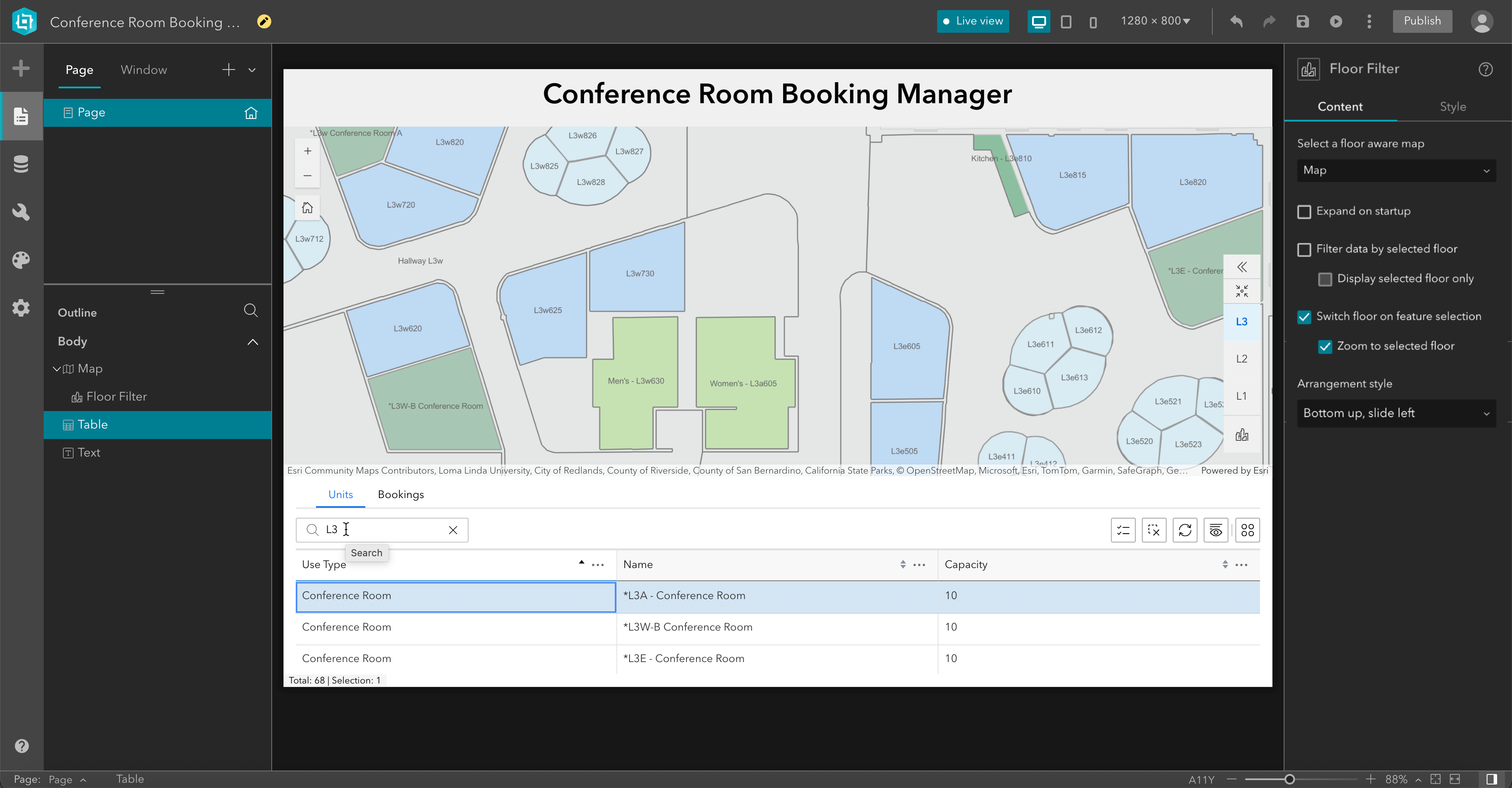
Set floor based on selection in data-centric widgets
If your Experience Builder apps are driven by data-centric widgets like Search, Query or Table, then you can now use newly introduced settings to set the floor in the floor filter than corresponds to the item selected in those widgets.
For example, if you select a record in the Table widget, the map can switch to the floor corresponding to selected record and zoom to the feature for an interactive experience.
Short share URL
Indoors Viewer and Indoors Mobile include a feature that allows a user to share a link to a specific location with others. For example, an organizer of a training session can share a link to the classroom so others can directly see the location when they launch the app and get directions to it instead of having to search for it. This release includes a highly requested enhancement where the share URL is now generated in the tiny url format like arcg.is/ab3cd6 which makes it very convenient to share with others.
Resources
For more information, please visit the ArcGIS Indoors product page. Join our Esri Community place to stay up to date and ask us any questions.


The ArcGIS Indoors Q2 2025 updates are a major leap forward for smart infrastructure management. As a GIS Developer at Gulf Coast Water Authority, I’m especially excited about the enhanced point cloud to floorplan tools and indoor routing capabilities—they offer practical solutions for managing complex utility facilities and treatment plants. The new Indoors Mobile 2.0 app also brings major improvements for field crews, enabling real-time navigation and asset location within indoor environments. These advancements will be key in transforming how water utilities manage their internal operations and infrastructure.