With the June 2020 update of ArcGIS Online, ArcGIS Notebooks has moved into general availability. It is no longer in beta. Here’s what you need to know:
All your beta notebooks carried over
You can keep using any notebook you created during beta.
Beta content in Files is no longer available
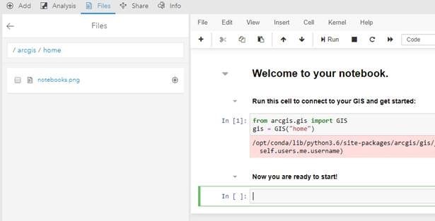
Files is your personal workspace. When Notebooks moved to general availability, all beta content that you created or stored in your Files workspace was removed. You start general availability with a clean slate. For example, in the notebook below there is a .png stored within Files, with the move to general availability this was removed.

Notebooks consume credits
Now that beta has ended, ArcGIS Notebooks follows the credit model used within ArcGIS Online. For notebooks, credits are charged per minute of notebook usage and the rate at which credits are charged depends on the type of notebook that is being used. There are 3 types of notebooks available within ArcGIS Online: Standard, Advanced, and Advanced with GPU Support.
Standard offers over 300 open source Python libraries plus the ArcGIS API for Python. Standard provides a small instance size (compute and memory resources), and is appropriate for administrative tasks, data engineering, and light analytics. Note that in the table below hourly rates and rates in USD have been provided for reference, but Notebooks only charge credits for the minutes you use. The Standard credit consumption rate is as follows:
Per minute Per Hour (for reference)
0 credits/minute = 0 credits/hour
$0 USD/minute = $0 USD/hour
That’s right – Standard does not consume any credits. If you would like to move any of your existing notebooks from a higher runtime, such as Advanced or Advanced with GPU Support to Standard you can do so by going to the notebook options on the item details page and changing the runtime option to Standard. Note that ArcPy and GPU enabled libraries are not available within Standard.
Advanced offers everything included in Standard plus ArcPy. Advanced provides a larger instance size (more compute and memory resources) and is appropriate for most workflows including large scale data engineering, advanced analytics, and some machine learning workflows. The rate is as follows:
Per minute Per Hour (for reference)
.05 credits/minute = 3 credits/hour
$0.005 USD/minute = $0.30 USD/hour
Advanced with GPU Support is identical to the Advanced offering except the instance used to power this notebook type is GPU-enabled providing the highest amount of compute and memory resources. This notebook type is best for computationally intensive (or memory intensive) workflows such as big data analytics, model training, and model inferencing. Rate as follows:
Per minute Per Hour (for reference)
.5 credits/minute = 30 credits/hour
$0.05 USD/minute = $3.00 USD/hour
These rates are for notebooks used in “Interactive Mode.” Interactive mode is when the someone is directly interacting with the notebook (the notebook is open and you can execute cells) in order to prototype, build a model, etc. When working in this mode you can open multiple concurrent notebooks simultaneously. When two notebooks of the same type and same version are used concurrently in interactive mode the per minute pricing only counts for one notebook. The benefit of this is that it allows for easy, cost-effective prototyping with a higher degree of freedom and flexibility. Be aware that with each release of ArcGIS Online we will include updated notebook runtimes – to take advantage of concurrent notebook pricing you will want to make sure that your notebooks are of the same type (Standard, Advanced, Advanced with GPU Support) and version (3.0, 4.0, etc.). You can find this information on the Item Details page for your notebook under the notebook settings.
Any notebook in interactive mode will incur a minimum of 10 minutes of credits (at the rate for the applicable notebook type). This applies if you use a notebook for less than 10 minutes, if you use more than 10 minutes you will be charged for the minutes that you use. For reference the minimum credit consumption per notebook type would be:
- For Standard the minimum charge is 0 credits ($0 USD).
- For Advanced the minimum charge is .5 credits ($0.05 USD).
- For Advanced with GPU support the minimum charge is 5 credits ($0.50 USD).
Be aware that there is a 20 minute idle timeout time on any interactive notebook. If you are inactive in your notebook for 20 minutes or more you will need to refresh the notebook kernel to continue work. The good news is you will not be charged credits for this final timeout.
Notebooks can also be run in “Scheduled Mode.” Scheduled mode is where a notebook has been scheduled execute autonomously (a human has not opened the notebook and is not manually running cells). To learn more about scheduled mode you can read the Scheduled Mode for ArcGIS Notebooks blog.
Remember that as a notebook author you get the option to select your notebook runtime when you launch a notebook. Keep in mind if you have not been granted Advanced Notebook privileges by an administrator a Standard notebook will launch by default as this is the only option you have available to you.
Join the GeoNet Community
Whether you want to talk about ArcGIS Notebooks in Online, Enterprise, or Pro join the ArcGIS Notebooks community . Ask questions, share ideas, and get help from your fellow notebook users. You can also visit the ArcGIS Notebooks product page for product level information and quick links to resources.
We are very excited to see what you do with ArcGIS Notebooks. Don’t forget that you can register for the 2020 Esri User Conference and can attend sessions on ArcGIS Notebooks and get access to the development team in the virtual UC Showcase to ask questions one-on-one.

Article Discussion: