
In today’s data-driven world, accurate location information is essential for everything from emergency response and broadband deployment to government planning and economic development. Recognizing the critical need for precise and trusted geospatial data, North Carolina has been actively sharing its authoritative point address data with Esri’s World Geocoding Service since September 2023. This collaboration supports a wide array of public services, ensuring that organizations, agencies, and individuals have access to the most reliable geocoding resources available.
Why North Carolina Shares Point Address Data with Esri
Esri’s World Geocoding Service is one of the most commonly used geocoding tools globally due to its ease of access and seamless integration into ArcGIS platforms. By contributing authoritative, current address data from across North Carolina, the state enriches Esri’s dataset with verified, high-quality data maintained by county and municipal governments.
Each dataset submitted through the AddressNC program is standardized to national schemas such as the National Address Database (NAD) and the National Emergency Number Association (NENA) standards. Hundreds of quality checks are performed monthly to ensure the accuracy and consistency of every field. The data includes all parsed fields essential for precise geocoding-each validated to meet Esri’s expected input standards. Esri accesses quarterly updates through a dedicated repository on NC OneMap, guaranteeing they always use the most recent information.
A Sustainable, Authoritative Data Model
North Carolina’s AddressNC initiative is a unique example of a sustainable data-sharing model. As a derivative of the state’s Next Generation 911 (NG911) initiative, AddressNC ensures continuous, standardized data delivery from all 100 counties. This guarantees the dataset remains current and reliable, giving users-from state agencies to local governments-confidence in its use for operational and strategic applications.
Empowering Real-World Applications
North Carolina’s authoritative address data supports a wide range of geospatial products and services:
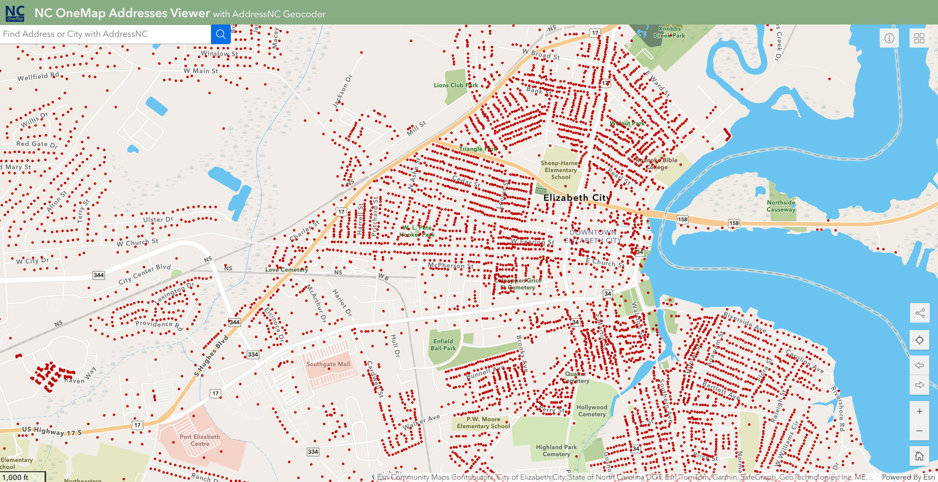
- Address Point Web Map
NC OneMap Address Points Viewer - NC OneMap Service Catalog
Service Access - Broadband Location Status Experience
Search Your Home or Business - Municipal Boundaries and Annexations
Municipal Boundaries and Annexations Status Tracker
These applications allow users to explore address locations, evaluate service coverage, and make critical public service decisions.
Tangible Benefits to State and Local Agencies
The collaborative relationship between North Carolina and Esri has brought significant benefits, including:
- Improved Geocoding Performance: Feedback from users has directly influenced the enhancement of locators, including setting higher confidence scores and refining intersection matching.
- Statewide Coordination: The Geographic Information Coordinating Council (GICC) identifies addresses as a critical framework dataset. Sharing AddressNC data helps fulfill GICC’s mission of providing accessible, high-quality GIS services across the state.
- Disaster Response and Resilience: Offline geocoding packages, available per county through NC OneMap, proved invaluable during Hurricane Helene, allowing emergency managers to access data even without internet access.
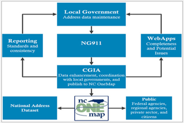
Integration with Next Generation 911
AddressNC is made possible due to the implementation of NG911 across North Carolina. Through a cyclical process of data submission, quality control, and feedback, local governments are continuously improving their address data. REST services provided back to the counties enable them to identify and correct inconsistencies-forming a sustainable, incentive-based model for ongoing data stewardship.
Use Cases Driving Statewide Impact
North Carolina’s address data powers a broad spectrum of impactful initiatives:
- Broadband Expansion: The Broadband Infrastructure Office (BBIO) uses address-level data to identify underserved locations and refine federal broadband grant challenges.
- Jury Equity Analysis: A partnership between UNC and NCDOT uses address-matched data to analyze fairness in jury selection across counties.
- Disaster Response: NCDOT utilized AddressNC to place temporary cell towers during Hurricane Helene, enhancing connectivity during the crisis.
- Neighborhood Services: The City of Durham improves community engagement by using standardized address lists for public meeting notifications.
- Public Services: Agencies like the State Fire Marshal use address data for inspections. Local governments use addresses to confirm annexations and boundary changes have been received by the State. The Land of Sky Regional Council uses addresses to validate commercial and residential locations for regional planning purposes.
A Model for Other States
With quarterly updates to the National Address Database and a robust framework for statewide collaboration, North Carolina has become a national leader in authoritative address data management. Through the AddressNC program and its partnership with Esri, the state is not only enhancing geospatial services but also enabling informed decision-making across sectors. From emergency response to broadband access, the benefits of reliable address data are far-reaching and growing every day.
Esri Community Addresses
Your organization can enhance the geocoding experience by contributing the most recent, accurate, and comprehensive point or polygon address data to the ArcGIS World Geocoding Service.
Click the image below to learn more.


Article Discussion: