The 3D Analyst extension offers new and improved capabilities in ArcGIS Pro 3.3. We’ve added new toolsets, enhancements, and bug fixes to improve the ArcGIS 3D Analyst user experience. Here’s a rundown of what’s new in 3D Analyst.
ArcGIS Pro 3.3 was released in May, 2024.
For a complete summary of all the changes that have been made for this release, have a look at the What’s New in ArcGIS Pro 3.3 blog post.
New Capabilities to ArcGIS 3D Analyst
Create Terrain Wizard:
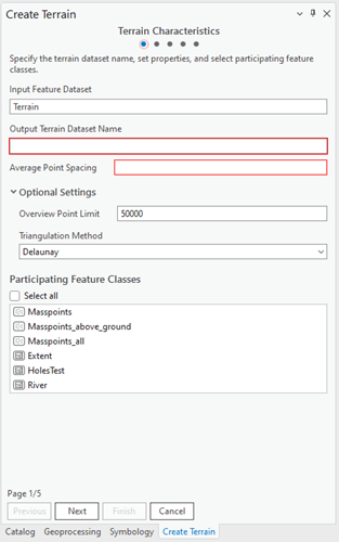
Back by popular demand, the Terrain Wizard has been added to your ArcGIS Pro project when paired with ArcGIS 3D Analyst. We like to use terrain datasets to create surface models when we have a variety of input data types. Sometimes, we’re fortunate enough to have point clouds, spot heights, contours, and even breaklines. If this sounds familiar, check out ArcGIS 3D Analyst and create a terrain with an easy-to-follow wizard while also being able to enforce height sources between features, define edges of elevation interruptions, and combine your Point contours with known spot heights.
As a refresher, A terrain dataset is built from multiple data sources like point clouds (lidar, single and multibeam, photogrammetry points, etc.), 3D breaklines, and 3D-based survey observations. The data sources for creating terrain datasets are managed as integrated feature classes in a geodatabase. Building a terrain dataset to efficiently visualize and store many source measurements can be lengthy. The Create Terrain wizard guides users through the entire workflow from start to finish to build a terrain dataset.

TINs:
Keeping with the theme of triangulated surfaces. New to ArcGIS Pro 3.3, you can enjoy an enhanced rendering experience when working with TINs. Launch the layer properties of your TIN and discover the new Display tab. By choosing the Display tab, you have the option to enable MapTips. This is helpful when you need to compare multiple surface models or inspect the height source of a given location.
New Workflows:
Esri’s 3D Team has worked hard to populate the 3D GIS resources website with new workflows. If you haven’t visited the new Resources page, take some time to check it out. We’ve been trying to help you by documenting common workflows that may not fall under a single tool or process. With ArcGIS Pro 3.3 being released, here are a couple of new workflows that might be helpful to you:
Geoprocessing tool enhancements
Below you’ll find all the other enhancements we’ve made for ArcGIS Pro 3.3.
Extract Objects From Point Cloud—Improved approximation of feature geometry is provided through alpha radius controls.
LAS Building Multipatch—Height profile information is leveraged to produce smoother buildings.
Generate Clearance Surface—Point features are supported as input.
Convert LAS—Creates backward compatible .zlas files for use in ArcGIS Pro versions earlier than 3.2.
Train Point Cloud Classification Model—GPU memory handling was improved.
The following tools have improved performance when downloading I3S point cloud services: Extract LAS. Point Cloud To Raster.
Interactive input support is available for the following tools: Enforce River Monotonicity, Extract Multipatch From Mesh, Generate Clearance Surface
Share Your Feedback
We value your feedback and would love to hear from you. If you encounter any issues, have suggestions, or just want to share your thoughts on the new update, please don’t hesitate to reach out to use Esri’s Community forum here.
Thank you for choosing ArcGIS Pro. We hope you enjoy the latest version, and as always, we’re committed to providing you with the best software experience possible. Stay tuned for more exciting updates in the future!


Article Discussion: