ArcGIS Pro 3.3 is now available! From flood simulation and presentations to direct PDF support and hyperlinks in layouts and reports, we’ll cover everything you need to know to make the most of ArcGIS Pro. Read on to learn more about some of our exciting new features and enhancements.

First, some housekeeping items
Before you dive into ArcGIS Pro 3.3, we want to make sure you’re prepared. It is crucial to have Microsoft .NET Desktop Runtime 8.0.x (x64) installed on your machines before installing ArcGIS Pro 3.3. You can download it here. ArcGIS Pro 3.3 remains fully compatible with other ArcGIS Pro 3.x versions, and your existing 3.x SDK extensions should continue to work. Learn more about the move to .NET 8 in this blog.
Additionally, ArcGIS Pro 3.3 requires Microsoft Edge WebView2 Runtime version 117 or later. If it is not already installed on the machine, use the Evergreen Bootstrapper or Evergreen Standalone installer from Microsoft. Learn more in this blog.
For more information and additional details about this release, check out the What’s new help topic or view all posts related to this release.
Don’t have time to read the blog article? View the video below instead.
Quick Links
Use the links below to jump to our release highlights.
- Modeling Realistic Water Flow
- Share Your GIS Story in ArcGIS Pro
- Add PDFs Without Converting to TIFF
- Hyperlink Your Text Elements
- Export Attachments With Ease
- Create New Geodatabase From Schema Report
- Combine Multiple Visualization Techniques
Release Highlights
Modeling Realistic Water Flow
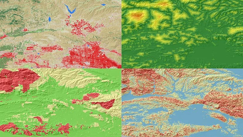
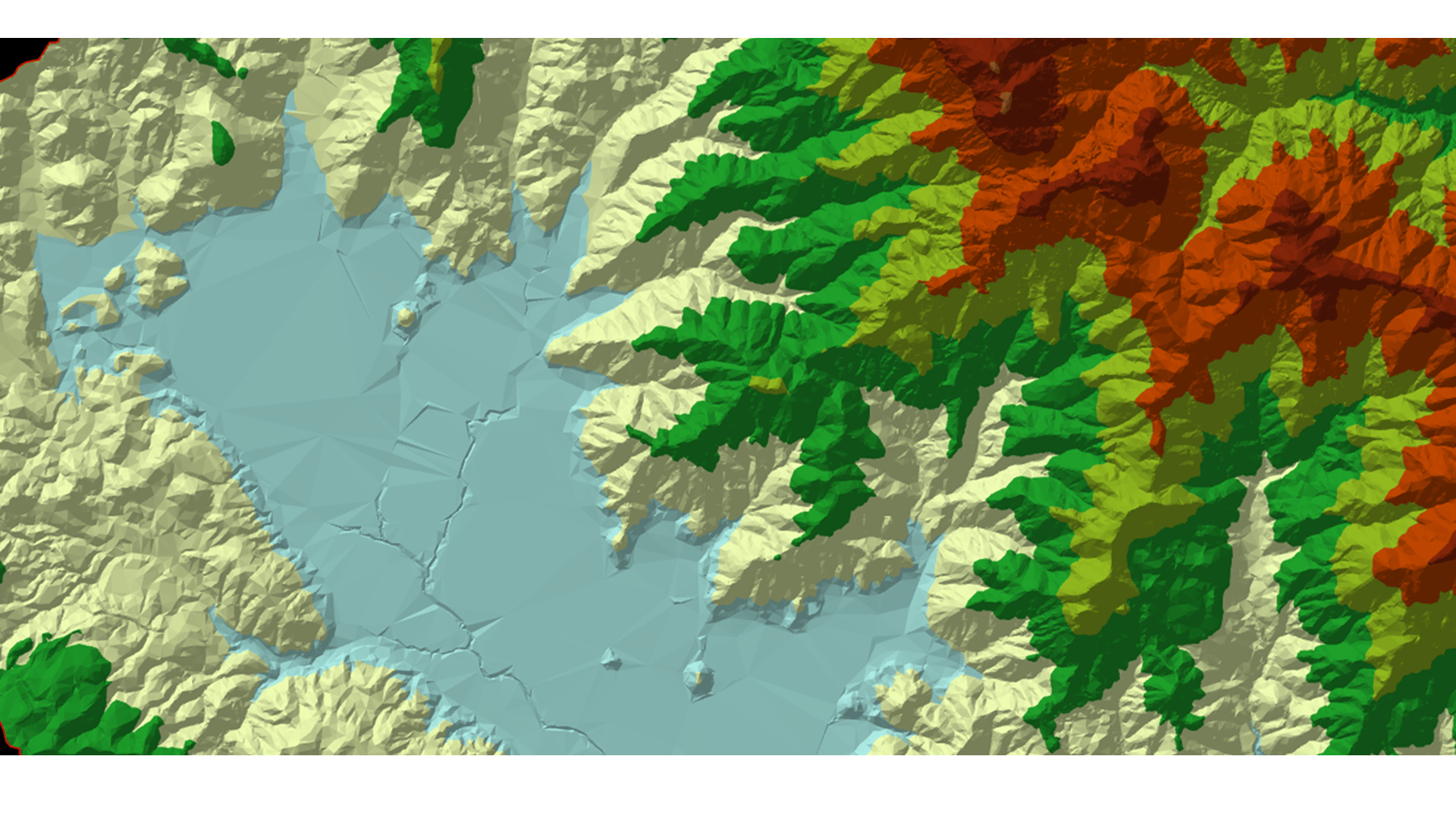
One of the standout features in ArcGIS Pro is the ability to perform dynamic flood simulations in 3D scenes. With flood simulation, create GeoDesign scenarios of water flow over elevation surfaces and around 3D objects such as buildings and walls. Whether you’re studying potential flood scenarios or planning for an emergency response, configure various behaviors such as rainfall, water sources, and barriers, and compare results. You can even export the analysis results as raster data to generate reports and maps. Check out the new flood simulation technical paper to learn how this additional capability can support your water-related projects.

Share Your GIS Story in ArcGIS Pro
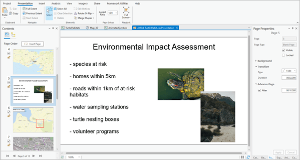
Presentations are a new addition to ArcGIS Pro, allowing you to organize maps, scenes, text, images, and videos into a captivating visual narrative. With Presentations, create a series of pages featuring selected content and explore maps and scenes in full-screen mode. You’re able to set page properties such as transitions, control layer visibility, and even share your presentation with others as PDFs, videos, or collections of images. For example, use this to provide an updated design proposal for a new development or highlight the results of a recent investigation. Get creative when sharing your GIS story using Presentations in ArcGIS Pro.
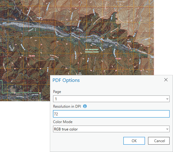
Add PDFs Without Converting to TIFF
ArcGIS Pro now offers direct support for PDF documents, allowing you to incorporate them into your mapping workflows without having to convert to a TIFF and store duplicate data. You can add individual pages of a PDF as raster layers to your maps or scenes, enhancing your imagery and mapping capabilities. PDF layers can be visualized, enhanced, and georeferenced. Even better is that they can be analyzed using the same raster functions and geoprocessing tools available for other raster layers. Annotation, labeling, attribute edits, and spatial reference updates can be saved to the source file. Export PDF layers to other raster formats and share them as web layers for cross-team collaboration.
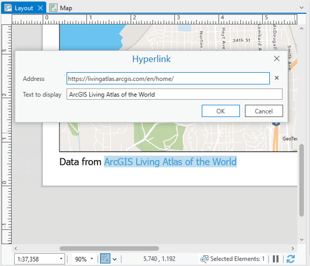
Hyperlink Your Text Elements
Hyperlinks are now supported in text elements for Layouts and Reports, adding a new level of interactivity to your projects. When a URL or full file path is added to a Layout text element, Layout table frame, or Report text, it is automatically recognized and linked. Furthermore, to complement this functionality, the new Hyperlink window enables you to easily create new and update existing hyperlinks. You can open the Hyperlink window with the classic Ctrl + K keyboard shortcut or the Text tab on the main ribbon. Support for hyperlinks is also honored when exporting layouts as PDFs.
Export Attachments With Ease
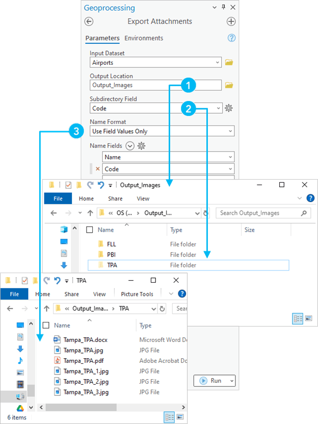
In response to the highly asked-for Esri Community idea “Batch attachment export,” the ArcGIS Pro development team built the Export Attachments geoprocessing tool. This tool simplifies the process of exporting file attachments from geodatabase feature classes or tables as well as applicable feature services. Attachments are exported to a specified folder and can be organized into subdirectories based on field values. The Export Attachments tool honors selected features in an active map or selected rows in a table, so make sure you double-check your selection before running it. This new tool is a time-saver for managing and sharing attachments.
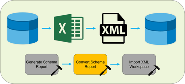
Create New Geodatabase From Schema Report
Executing data modeling tasks just got easier. In ArcGIS Pro 3.2 we introduced the ability to create a report of your geodatabase schema with the Generate Schema Report tool. In response to the following feedback we received on Esri Community, the ArcGIS Pro 3.3 release introduces the new Convert Schema Report geoprocessing tool to convert the output of the Generate Schema Report geoprocessing tool to another file format (.xlsx, .pdf, .html, .json, or .xml). You can reorder fields, align spatial references, assign domain values, and more. Then take those schema changes and incorporate them into a new geodatabase.
Combine Multiple Visualization Techniques
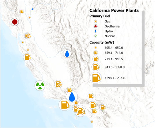
With ArcGIS Pro 3.3, you can classify categorical data with unique values symbology by specifying size or color variables. For example, you can classify point features representing different types of power plants by type and use symbol size to show power capacity. This feature provides a comprehensive view of your data, highlighting variations that would otherwise be missed.
Explore Performance and Productivity
In addition to these exciting new features, ArcGIS Pro 3.3 has also received significant performance and productivity enhancements. The geoprocessing framework now uses workspace caching, resulting in faster script execution and repeated processes. Tools like Enrich Layer, Distance Accumulation, and Distance Allocation have also been optimized for better performance. You can now convert text elements to rectangle text elements on layouts. Additionally, you can choose to show selected symbols when exporting maps or layouts and preview reports before exporting them. Browse the help documentation to access more detailed information on performance and productivity improvements.
Stay Connected
For further information, please visit the What’s New documentation and post your questions in the ArcGIS Pro place in Esri Community.
Make sure you follow the ArcGIS Pro X (formerly Twitter) page and join our LinkedIn group to be the first one to discover new content from the team.
Expanding ArcGIS Pro Capabilities
Notable Mentions for ArcGIS Pro Extensions in the 3.3 release
The ArcGIS Pro 3.3 release introduces a redesigned version of the IPS information model that natively represents the data as point and polygon features, as well as IPS-aware maps. These two updates enable unprecedented insights into indoor positioning data while streamlining the enablement of indoor positioning. For more information, please read the ArcGIS IPS release blog.
ArcGIS Aviation Airports and ArcGIS Aviation Charting, introduces new and enhanced tools to better support your airport, charting, data management, migration, and design tasks. Additionally, the Product data files include new scripts that facilitate productivity and provide standardization and consistency across your operations. Read the blog to learn more.
This May release introduces more ways to leverage video in ArcGIS. You can now apply video layers to analysis workflows in ArcGIS Pro with ArcGIS Image Analyst and ArcGIS AllSource, the newest client applications for ArcGIS Video Server. Read this article to learn more.
ArcGIS Bathymetry, an extension to ArcGIS Pro, provides tools to manage large volumes of bathymetric data. With the release of ArcGIS Pro 3.3, all the bathymetry tools in the Bathymetry toolbox are now accessible from the ArcGIS Pro toolbox. This means you are no longer required to manually add them to ArcGIS Pro from the Bathymetry product files. Read the blog to learn more.


Commenting is not enabled for this article.