Upgrading arcgisbinding when using ArcGIS Pro 3.0
The recent release of ArcGIS Pro 3.0 offers many exciting new features and functionalities. While many users are thrilled to upgrade to the new version, one of the most concerning questions for the R-ArcGIS Bridge users is: Can I still integrate ArcGIS Pro 3.0 with R? The answer is YES! To leverage the power of ArcGIS along with R data science packages, the only requirement is to upgrade R to 4.2.0+ and update arcgisbinding, the R-ArcGIS Bridge’s R package, to Version 1.0.1.300.
There are two ways to update or check updates for the arcgisbinding.
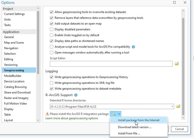
Option 1: Upgrade through ArcGIS Pro > Settings

After opening the Pro 3.0 backstage, go to the ‘Settings’ tab on the left hand side. Then choose Options > Geoprocessing. Under the R-ArcGIS Support section, click on the icon and select ‘Install package from the Internet’.
Option 2: Install within R
First, make sure you are on a supported R version (4.2.0 or later). Simply install arcgisbinding through: `install.packages(“arcgisbinding”, repos=”https://r.esri.com”, type=”win.binary”)`
Unsupported versions of R in the R-ArcGIS Bridge
The R-ArcGIS Bridge provides R-based geoprocessing tool support for versions from 3.5.X, 3.6.X and 4.2.X. However, it does not support R versions 4.0.X and 4.1.X. For these unsupported R versions, we have released an arcgisbinding package that will inform you that running geoprocessing tools is not supported. In case you are working on any of the unsupported R versions mentioned above, and you are looking to install the arcgisbinding package through the ArcGIS Pro Geoprocessing tab, you don’t need to worry about the arcgisbinding version, as it will be automatically matched to the version that does not support geoprocessing execution.


If you still try to run a R-based geoprocessing tool on an unsupported version of R, the first time there will be a pop-up error message that will advise you to upgrade to another R version in which this functionality is supported, as shown in the screenshot below.

This error message will only be shown once, and subsequent attempts of running a R-based geoprocessing tool will result in a runtime error.

If your specific project requires R versions 4.0.X and 4.1.X, you can still use the R-ArcGIS bridge for all other functionalities, but if you need to create a geoprocessing tool from your R script, then we advise you to upgrade your R version to 4.2.0 or later.
Conclusion
The R–ArcGIS Bridge is fully functional in the newly released ArcGIS Pro 3.0. To integrate the R-ArcGIS Bridge with ArcGIS Pro 3.0, please make sure you upgrade your R version to 4.2.0 or later and install arcgisbinding version 1.0.1.300.
In addition, R-based geoprocessing tool execution is not supported in R versions within 4.0 and 4.1 and the corresponding arcgisbinding package version will advise you through a pop-up error message to upgrade your R version when attempting to run a geoprocessing tool. This error message will only be shown once, and later executions will result in a runtime error. Therefore, we advise you to use the arcgisbinding package with R versions 4.2.0 or later.
Learn more about the R-ArcGIS Bridge on our product page and let us know of any feedback you may have on our Esri Community page.


Article Discussion: