The ArcGIS Roads and Highways and ArcGIS Pipeline Referencing extensions include a variety of new and enhanced features for the ArcGIS Pro 3.5 and ArcGIS Enterprise 11.5 releases.
ArcGIS Pro Capabilities
The ArcGIS Pro 3.5 release includes a variety of new tools and capabilities around data product creation for reporting, dynamic segmentation, event editing, and streamlining common post route editing tasks.
LRS data products for reporting
ArcGIS Roads and Highways and ArcGIS Pipeline Referencing serve as a system of record for many organizations. The ability to leverage this system of record to better support decision-making and compliance reporting is a need that was addressed through new data reporting workflows initially released in ArcGIS Pro 3.4. In the latest release, this workflow now includes support for new data product types and other customer-requested enhancements.
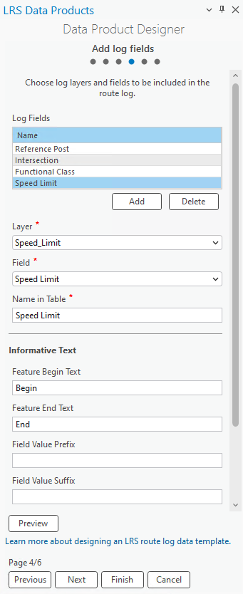
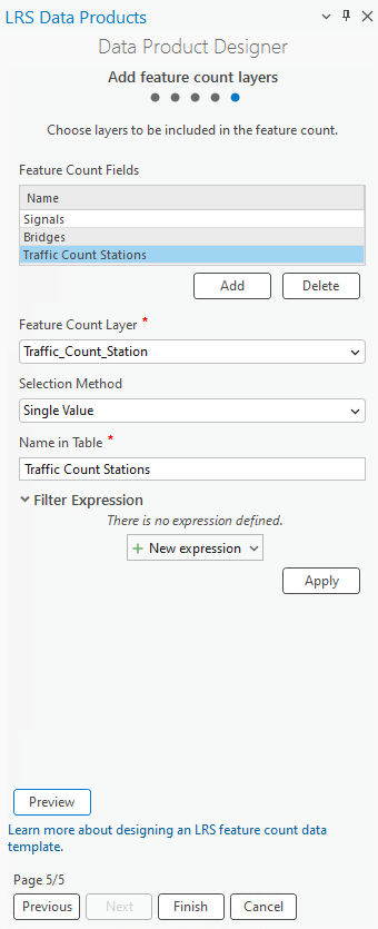
New data product types include:
A log type which supports reporting on the measures for events and intersections along a route(s) in the LRS Network. This log mimics walking along a road or pipe from the beginning to the end and seeing the measure on the route where specific points, like signs, intersections, and stations, are located. Additionally, as linear events, such as class or speed limit, change, the log will show the measure where those features begin and end along the route.
A count type which supports being able to report on the count of features along a route or within a geographic location. An example of this would be to understand the number of anomalies found along a pipe or the number of crashes that occur within a city or county.
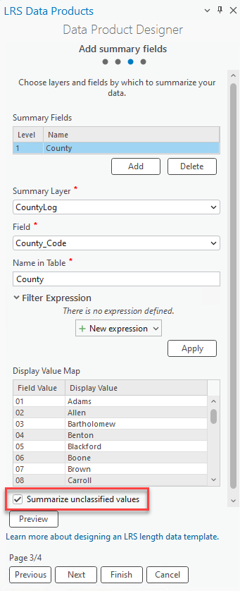
Additionally, in length data products, users are now able to summarize unclassified values. Enabling this option will allow users to get the length of event attributes that are not within a classification layer, such as an administrative boundary. For routes that are both inside and outside of an administrative boundary, length will be calculated for both sections. For example, if a road goes through multiple cities within a county as well as in unincorporated areas, the length data product output will include the lengths within each city the route goes through as well as the length outside of those cities in the unincorporated areas.
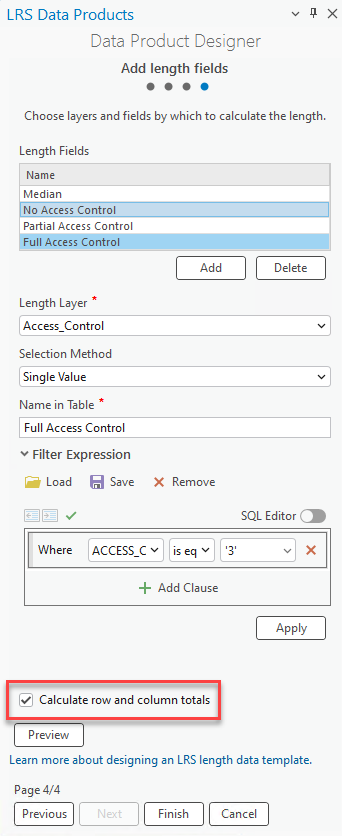
Also included in this release is the ability for row and column totals to be calculated for length data product outputs. For users that need to know the overall length totals for specific attributes or summary layers, enabling this option in a data product template will provide those totals in a separate column when executing the Generate LRS Data Product geoprocessing tool. This allows this information to be included in any report, dashboard, or application that shares this output data.
LRS event editing enhancements
The Add Point Event, Add Multiple Point Events, Add Line Event, and Add Multiple Line Events tools in ArcGIS Pro now include the ability to locate new events that come in from collection in the field or in engineering drawings via offset from a point feature. These point features could be LRS events, such as mileposts or stations, LRS Intersections, or point features not managed as events that are present in the map. Users no longer need to convert events that come in via this format to route and measure as it will automatically be converted as part of the process where the event is created when running one of the tools.

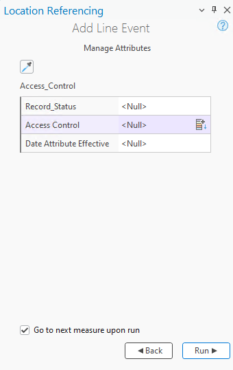
Also new this release is the Go to Next Measure Upon Run option in the Add Line Event and Add Multiple Line Events tool. This capability is useful when users are adding event(s) moving along a route from start to end. When the option is enabled, the line event(s) are added and the To Location of the newly created event(s) becomes the From Location of the next edit in the Add Line Event/Add Multiple Line Events tool interface in ArcGIS Pro. When adding multiple events along a line, having this information automatically populated should save the need to repopulate the From Location and ensure there are no gaps between newly added events.
Update measures from LRS enhancements
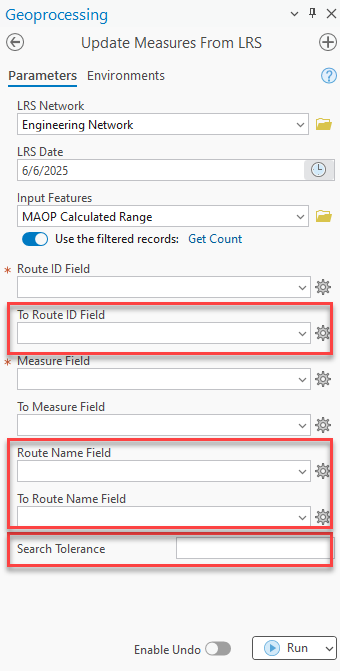
Multiple enhancements have been added to the Update Measures from LRS geoprocessing tool. The tool is used to populate or update route and measure information on point or line features. A search tolerance has been added to the tool, allowing features located within a specified tolerance of a route to have the route and measures of the nearest location to be added to the feature in the tool output.
For LRS Networks with Route Names configured, route name field(s) in the input layer are now updated in the output alongside the route and measure fields.
Additionally, for LRS Networks that support lines, events that span routes are now supported by the tool. Instead of including just the RouteID field in the output, the tool will populate a From RouteID and To RouteID for events that span across more than one route but are contained on a single line.
The tool now also supports LRS Events and LRS Intersections as the input features to be updated. For users that want to maintain the route and measure information for multiple LRMs on an intersection or event layer, this capability allows users to not have to duplicate these layers. Instead of maintaining intersections and event layers for each LRS Network, they can be associated with one network but still get route and measure information for each LRS Network in the LRS on a single feature.
Append events support for appending to primary route
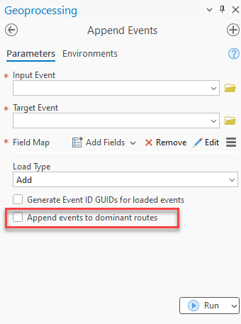
The Append Events geoprocessing tool automates the loading of event features from data sources such as tables, feature classes or .csv files. In this release, the tool has a new parameter to support adding the appended events to the primary (dominant) route in the network. For users that support concurrent (overlapping) routes, this option ensures that any events appended are always located on the primary route. Even if the route and measure information for the input event would place it onto a subordinate route where a concurrency exists, the tool will automatically place it onto the primary route with the corresponding route and measure of that primary route.
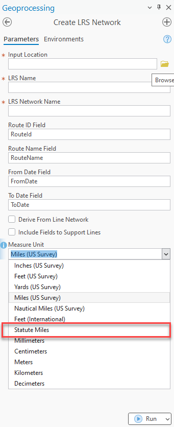
Support for statute (International) miles
When creating an LRS Network, statute (international) miles is now a supported unit of measure. For organizations that need to utilize statute miles, they can now be configured in the Create LRS Network and Create LRS Network from Existing Dataset tools.
ArcGIS Enterprise Capabilities
Modernized external event configuration and deployment
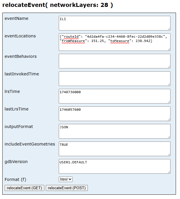
To support a modern WebGIS, the external event configuration and Relocate Event REST operation have been updated. Previously, users were required to maintain a direct read-only connection to the external event data source for the Relocate Events operation to determine the event records that would be included in the tool output when it completed successfully. At this release, additional methods are supported that remove the requirement for a read only connection to the external data. Users can now configure external events with or without a connection file. In the Relocate Events operation, users can continue to point an external event with a connection file or if they configured the external event without a connection file, include the routes and measures of the external event data they want relocated by the tool in its output. This provides a higher level of control of which event records from the external data source are considered for relocation within the tool when run. For example, 3rd party software that integrates with ArcGIS Roads and Highways and ArcGIS Pipeline Referencing can now break event data to be updated by the tool into small chunks, such as by administrative boundaries or specific routes, and process it in batches instead of always having all records automatically considered when the tool runs.
Address Data Management Support
For agencies who maintain both addressing and roadway characteristic information in ArcGIS Roads and Highways (and for many in combination with Esri’s Address Data Management solution), additional capabilities have been added to support these deployment patterns.
See the Integrating Address Data Management Solution with ArcGIS Roads and Highways blog for more information.
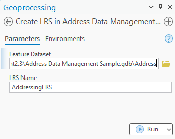
Configure LRS with Address Data Management solution tool
For users adopting the combined Roads and Highways and the Address Data Management solution deployment pattern, a new python script is available to create your LRS and the required schema items within the geodatabase that comes with Address Data Management. Users can run this script on their geodatabase and the minimum schema items for the LRS will be created within the feature dataset and the LRS will be created with all the correct fields mapped and configured. The script is available at https://github.com/Esri/LRSAddressDataManagement.
Address range information updates in dynamic segmentation
At this release both the Overlay Events geoprocessing tool and the Query Attribute Set REST operation now support an option to split the centerline or event layer with address range information . When records from those layers are split during dynamic segmentation, the address information is updated based on the nearest upstream and downstream site address points on the left and right side of the road. This option is in addition to the proportional method that was added in the previous releases.
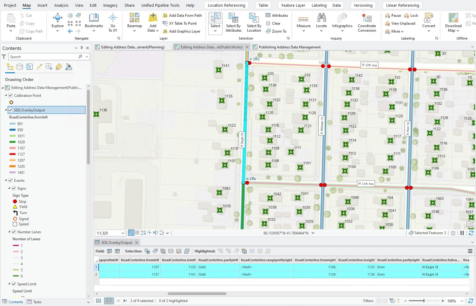
The example below illustrates this new capability. The centerline representing N Eagle St as it approaches W 12th Ave has the number of lanes change from 2 to 3. The address block range information on the centerline is 1106 to 1136 and 1107 to 1141, however the nearest upstream and downstream site address points to the location where the lanes change is 1120 and 1123.
When the centerlines that make up N Eagle St and number of lanes LRS event are included in a dynamic segmentation of N Eagle St, there will be segmentation along the centerline where the number of lanes change. The address ranges for the centerlines are updated in the output of the dynamic segmentation to 1107 to 1125, 1106 to 1122 for the first segment, and 1127 to 1141, 1124 to 1136 for the second segment.
Come, see us at the upcoming Esri User Conference to learn more.

Article Discussion: