Artificial intelligence has transformed how we analyse imagery. Today, pretrained deep learning models, geospatial foundation models, and vision-language models can detect objects, classify land cover, monitor environmental change, and extract information from imagery with remarkable accuracy.
But regardless of how advanced an AI model becomes; there is one fundamental limitation it cannot overcome:
AI can only see what the sensor was able to capture in the first place.
Imagine trying to detect an individual person in aerial imagery with a spatial resolution of 50 centimetres. Even the most sophisticated AI model is unlikely to succeed consistently, not because the model is inadequate, but because the person simply isn’t represented by enough pixels to be distinguished from the surrounding environment.
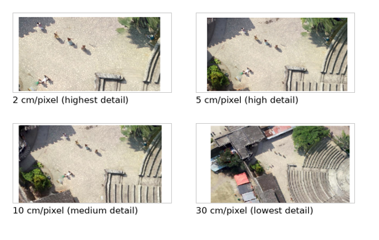
This is one of the most important principles in GeoAI. When a model produces poor results, the problem is not always the model itself. Sometimes the imagery simply doesn’t contain the visual information required for the task.
As GeoAI becomes increasingly accessible through pretrained models and foundation models, understanding the relationship between imagery and AI is becoming just as important as selecting the right model.
What is spatial resolution?
Spatial resolution describes how much ground area is represented by each pixel in an image.
For example, imagery with a spatial resolution of 50 centimetres means that every pixel represents approximately a 50 × 50 cm area on the ground.
The smaller the ground area represented by each pixel, the greater the spatial detail the imagery can capture.
That detail directly influences what objects can be visually distinguished, and therefore what an AI model has enough information to recognize.
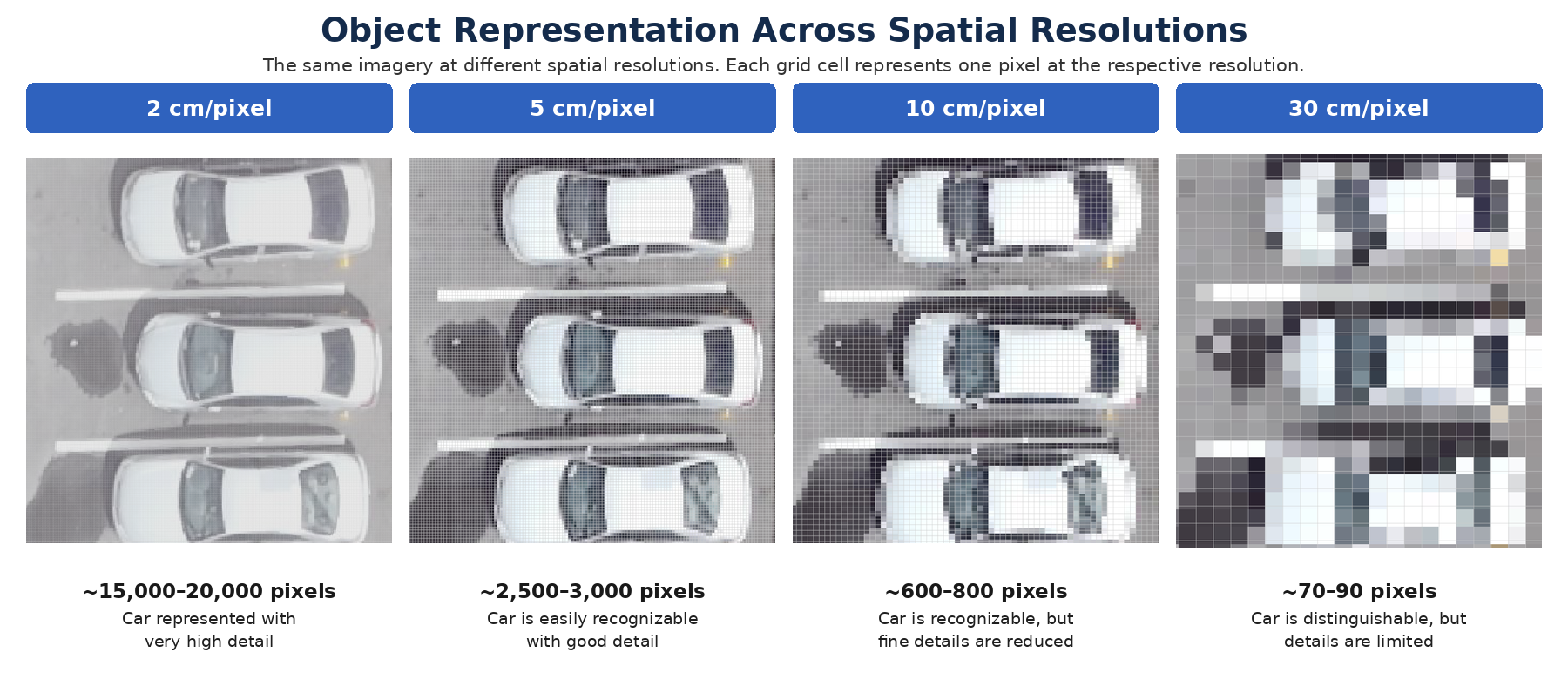
As the spatial resolution decreases, each pixel covers a larger ground area,
reducing the amount of information available to represent the object.
An object such as a large building may be represented by hundreds or thousands of pixels and can be clearly distinguished. A car may be represented by far fewer pixels but still retain enough spatial information to be recognized. A person, however, may occupy only a handful of pixels or even a fraction of a pixel, depending on the resolution.
The exact resolution required for a workflow depends on several factors, including the size of the object, the sensor, image quality, viewing conditions, and the AI model being used.
There is no universal minimum number of pixels required to recognize an object. The answer depends on several factors, including:
- Object size
- Sensor characteristics
- Image quality
- Viewing geometry
- The AI model itself
The important principle is simple: An object must be sufficiently represented in the imagery before an AI model can reliably identify it.
Different Problems Require Different Spatial Detail
There is no single “best” spatial resolution for every GeoAI workflow.
The appropriate imagery depends entirely on the question you’re trying to answer.
Large geographic features such as agricultural fields, forests, rivers, or land-cover classes can often be analyzed effectively using medium-resolution satellite imagery.
Smaller features including vehicles, utility infrastructure, rooftops, or individual people typically require imagery with much finer spatial detail.
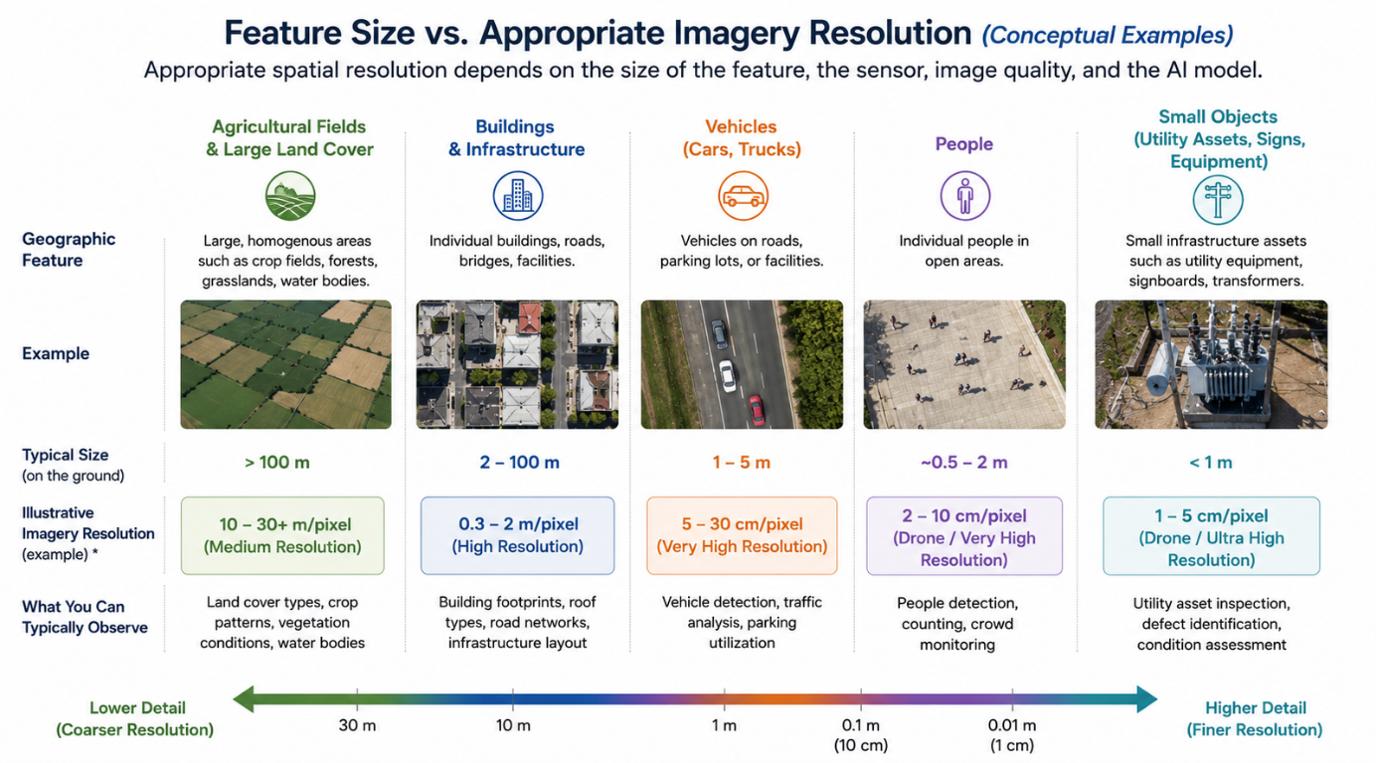
The important point is that higher resolution is not automatically better.
Higher-resolution imagery usually means:
- Larger datasets
- Longer processing times
- Higher storage requirements
- Greater acquisition costs
The goal isn’t to use the highest-resolution imagery available.
It’s to use the right resolution for the problem you’re trying to solve.
Spatial Resolution Affects More Than Object Detection
When people think about spatial resolution, they often associate it with object detection.
In reality, it influences nearly every GeoAI workflow.
These include:
- Object detection
- Pixel classification
- Semantic segmentation
- Change detection
- Feature extraction
- Similarity search
- Object tracking
Suppose your objective is to detect changes to individual buildings after a natural disaster. The buildings must be clearly represented in the imagery for those changes to be identified reliably.
On the other hand, if your goal is to classify broad land-cover categories across an entire country, medium-resolution imagery may be entirely sufficient and often much more efficient.
The “best” imagery always depends on the scale of the problem.
Better AI Doesn’t Replace Understanding Your Imagery
Foundation models and increasingly powerful AI models are changing how we work with geospatial imagery.
Many workflows that once required collecting large, labelled datasets and training specialized models can now be performed using pretrained models, zero-shot approaches, embeddings, and natural language-driven AI. But more capable AI does not eliminate the fundamentals of remote sensing and image analysis.
In many ways, understanding the input data becomes even more important as AI becomes easier to use.
There can sometimes be a perception that AI can do almost anything with imagery. AI has certainly expanded what is possible, but an AI model cannot recover spatial information that was never captured by the sensor.
If an object is too small relative to the pixel size, the model has limited information available to determine what that object is.
This is why selecting an AI model should not happen independently of understanding the imagery being analyzed.
Spatial Resolution Is Only Part of the Picture
Spatial resolution is one of the most important considerations, but it is not the only characteristic of imagery that can affect an AI workflow.
Depending on the task, it can also be important to understand:
- Spectral characteristics: Which portions of the electromagnetic spectrum does the sensor capture?
- Sensor type: Is the data optical, multispectral, hyperspectral, thermal, or synthetic aperture radar (SAR)?
- Temporal resolution: How frequently is imagery collected over the same location?
- Radiometric characteristics: How precisely can the sensor distinguish differences in measured energy?
- Image quality and conditions: Are clouds, shadows, atmospheric effects, viewing angles, or other factors affecting what can be observed?
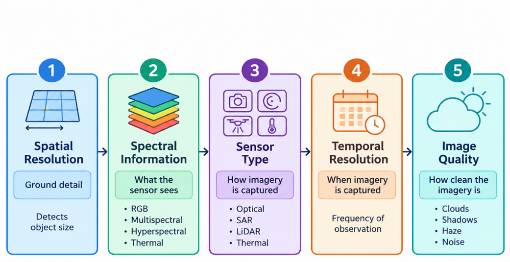
The importance of each characteristic depends on the task.
For example:
- Detecting small objects often depends heavily on spatial resolution.
- Differentiating vegetation species may rely more on spectral information.
- Monitoring floods or crop growth may require high temporal frequency.
- Imaging through clouds or at night may require SAR imagery.
Successful GeoAI workflows consider all of these factors together.
Start with the problem, then evaluate the imagery
You don’t need to be a remote sensing expert to use GeoAI.
However, having a basic understanding of your imagery can make a significant difference when selecting a model and designing an AI workflow.
Before asking:
“Which AI model should I use?”
It may be worth asking:
“Does my imagery contain enough information for the task I’m trying to solve?”
A useful way to approach a GeoAI workflow is to start with the problem and work backward.
- Define the object, feature, or phenomenon you want to identify or analyze.
- Consider its approximate size and characteristics on the ground.
- Determine whether those characteristics are represented clearly in the available imagery.
- Evaluate other relevant properties of the imagery, including spectral information, sensor type, and temporal characteristics.
- Select an AI model designed for the type of imagery and task you are working with.
- Validate the results using representative data from the areas and conditions where the model will be applied.
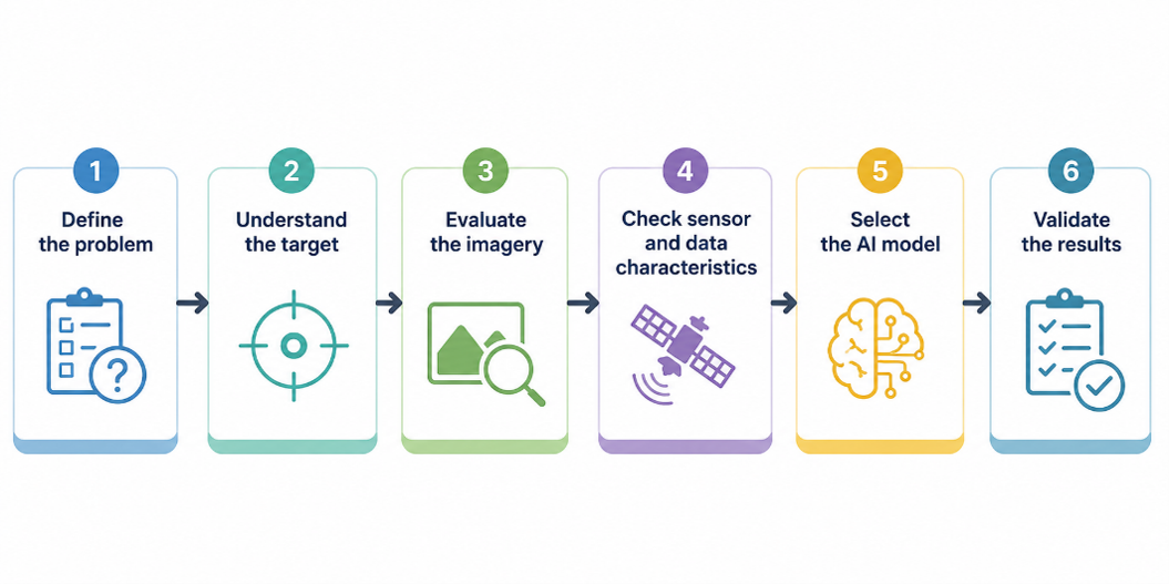
This approach can help identify potential limitations before investing significant time in model testing or deployment.
Bringing together the right data and the right AI
GeoAI is advancing rapidly. Foundation models, vision-language models, and new approaches to computer vision are expanding what can be accomplished with geospatial imagery.
But successful GeoAI workflows still depend on the relationship between the problem, the data, and the model.
Choosing the right imagery can be just as important as choosing the right AI model.


Article Discussion: