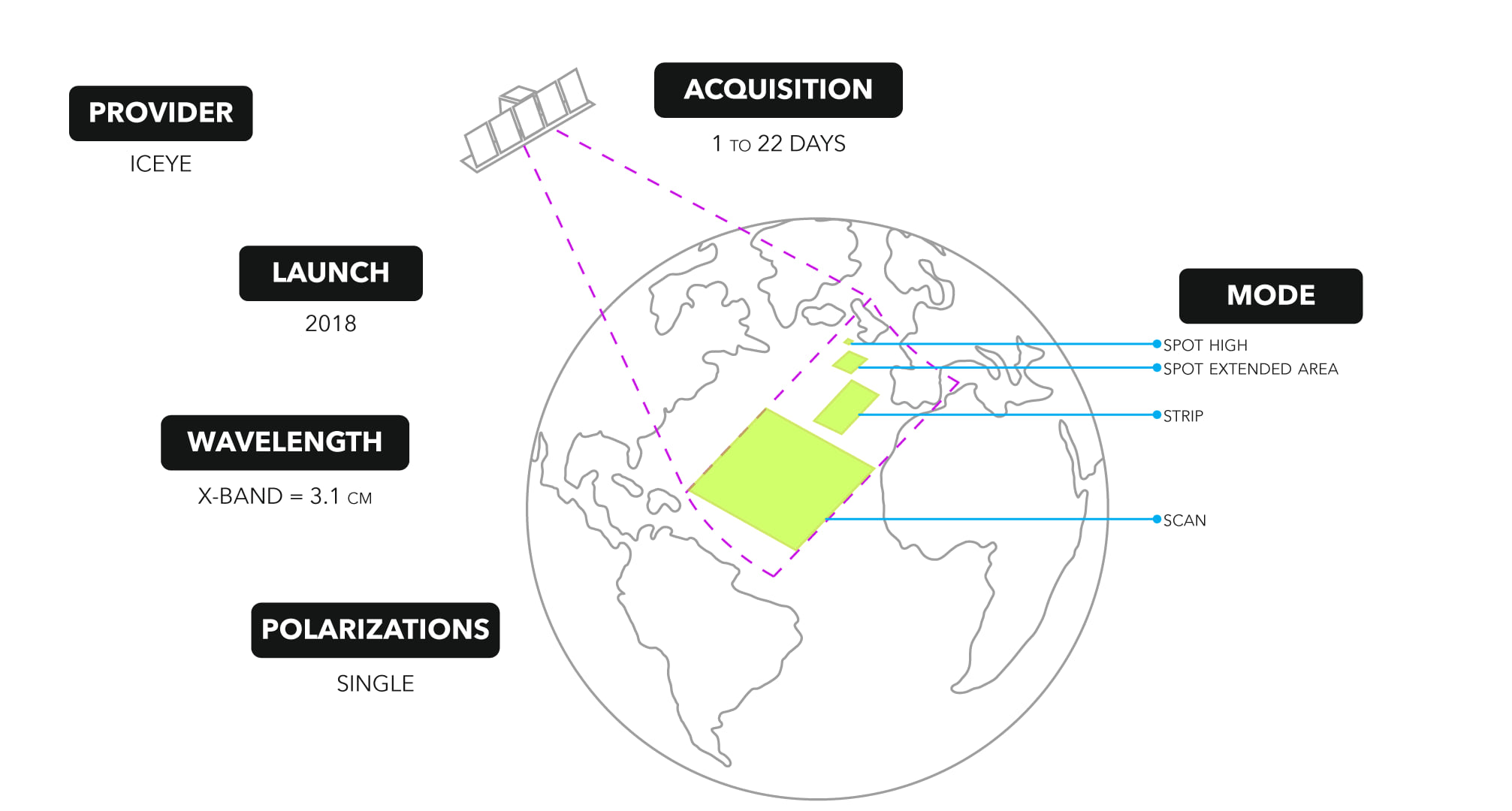
Happy GIS Day! Whether you are a GIS analyst, a scientist, an earth and space enthusiast, or simply curious about the technical capabilities of Synthetic Aperture Radar (SAR) satellite imaging, let’s delve into the wonders of ICEYE satellite technology and learn how the ArcGIS Pro Synthetic Aperture Radar Toolset supports ICEYE SAR data! This article will answer questions such as “Who is ICEYE?”, “What SAR products are supported in ArcGIS Pro?” and “How does the ArcGIS Pro Synthetic Aperture Radar toolset support ICEYE SAR satellite data?”.
Who is ICEYE?
ICEYE is a Finnish Earth observation company that specializes in synthetic aperture radar (SAR) satellite imaging. Founded in 2014, ICEYE aims to provide reliable and timely information about our changing planet through its constellation of small SAR satellites. These satellites capture high-resolution images of the Earth’s surface, enabling monitoring and analysis of various phenomena, including natural disasters, environmental changes, maritime activity, and infrastructure monitoring. ICEYE’s SAR technology allows for imaging regardless of weather conditions or time of day, providing insights for a wide range of applications.
To learn more about their story, visit the timeline here.
What SAR products are supported in ArcGIS Pro?
Many SAR sensors are available and supported as raster types in ArcGIS Pro and each has various products and polarizations. The ICEYE SAR commercial microsatellite constellation satellites collect data in many imaging modes. Here are the modes supported in ArcGIS Pro: with coverage of up to 100 kilometers and resolution as fine as 1 meter.
The supported ICEYE products:
- Ground Range Detected (GRD)—These products are images that have been multilooked and projected to ground range using an Earth ellipsoid model. A GRD image is stored as a real value array. The value in each pixel represents the amplitude of the reflected backscatter signal. GRD products contain approximately square resolution pixels and square pixel spacing.
- Sensor Independent Complex Data (SICD)—These products are Single Look Complex (SLC), images in the slant range. An SLC image is stored as a complex value array. The single complex value in each pixel represents the amplitude and phase of the reflected backscatter signal.
The X-band sensors operate at a center frequency of 9.65 GHz (wavelength of approximately 3.1 centimeters) and the supported imaging modes include a single polarization (VV) product.
How does the ArcGIS Pro Synthetic Aperture Radar toolset support ICEYE SAR satellite data?
Users can access the ArcGIS Pro Synthetic Aperture Radar toolset with the Image Analyst license. ArcGIS Pro treats the supported SAR sensor data as a raster layer with radar properties and capabilities; the support level depends on the sensor. It’s good to note that once the dataset has been processed by a tool outside the Synthetic Aperture Radar toolset, it is no longer considered a radar layer.
The table below lists the geoprocessing tools available for ICEYE data.
| Apply Radiometric Calibration | Apply Radiometric Terrain Flattening | Despeckle | Apply Geometric Terrain Correction | Convert SAR Units | Multilook | |
| ICEYE GRD | ✓ | ✓ | ✓ | ✓ | ✓ | ✓ |
| ICEYE SICD | ✓ | ✓ | ✓ | ✓ | ✓ | ✓ |
If you haven’t read “Simple steps to add SAR satellite data to your ArcGIS Pro map”, it might be worth a virtual page turn to learn more about SAR sensors, SAR products, SAR raster products, and SAR raster types. Also, visit this StoryMap about SAR satellite data.


Article Discussion: