In today’s data-driven world, extracting meaningful insights from complex imagery is more crucial than ever. The Spring 2025 release of ArcGIS Pro significantly enhances the ability to extract more information from images by offering additional hyperspectral and Synthetic Aperture Radar (SAR) analysis capabilities. This release also expands the range of supported data types, ensuring that you have access to the most detailed and diverse data available. By leveraging these new features, you can expect to improve your geospatial analysis capabilities, streamline your workflows, and gain more accurate and actionable insights.
Read on to discover how ArcGIS Pro 3.5 will transform the way you work with imagery and raster data.
Key Features of this release:
- Advanced Imagery Analysis Capabilities
- Detect anomalies in an area of interest
- Simplify creating analysis-ready SAR data
- Enhanced Deep Learning and Model Interpretability
- Understand model decisions with support for Grad-CAM
- Real-time model performance with TensorBoard integration
- Evaluate Pixel Classification accuracy with GP tool
- New and Enhanced Support for Data Types
- Detailed hyperspectral imagery with Hyperion
- Maxar WorldView Legion imagery support
- THEOS-2 imagery integration
- Vexcel Ultracam M3 aerial imagery support
- Support for video file formats
- Improved PowerPoint templates and video multiplexer flexibility
- Streamlined Image Management
- Add STAC items as single layers to reduce clutter
- Expand data accessibility and security with tiled imagery layers
- Improved Visualization Capabilities
- Overlay GIS features in Oriented Imagery layers
- Better feature visualization with Stereo imagery
- Improved raster performance in Stereo Map
- Expanded image enhancement capabilities
- Support for Stealth-V Type mouse
Advanced Imagery Analysis Capabilities
This release enhances the ArcGIS Image Analyst extension for ArcGIS Pro, boosting its analytical capabilities for better interpretation of features and phenomena on the earth. By integrating advanced hyperspectral and SAR data, you can now perform more comprehensive and precise analyses. This expansion of tools and data types is invaluable for a wide range of applications, from environmental monitoring to military surveillance, ultimately improving decision-making and operational efficiency.
Hyperspectral Analysis
Detect anomalies in an area of interest
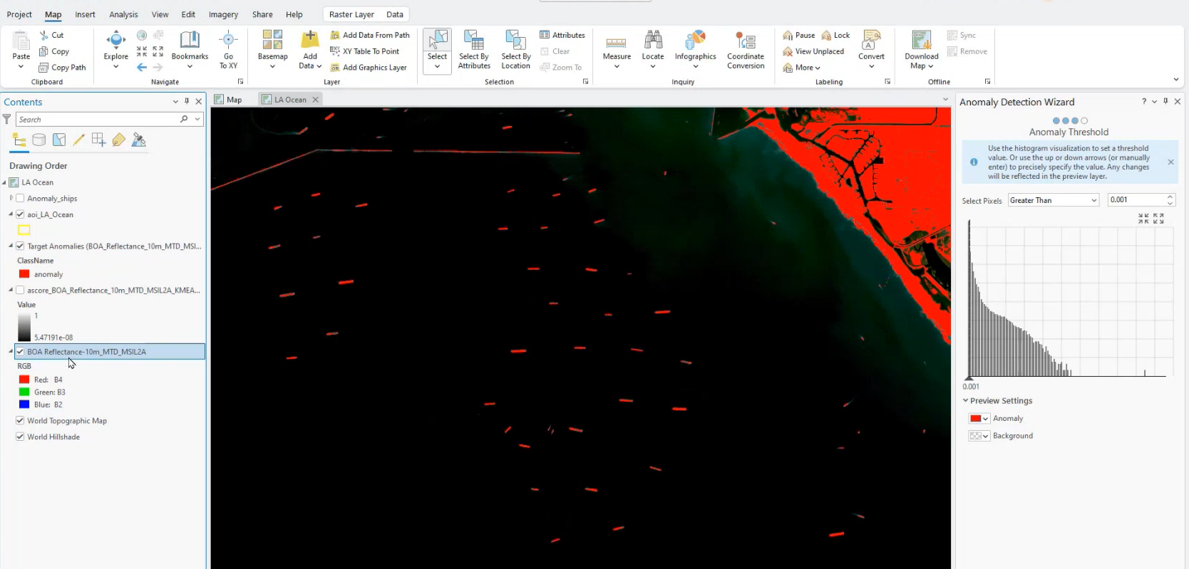
One of the standout features in the hyperspectral analysis toolkit is the Anomaly Detection Tool. This tool enables you to detect anomalous features on the ground using multispectral and hyperspectral data. By identifying areas with unique spectral signatures that stand out from the surrounding environment, you can pinpoint hidden vehicles, camps, structures, or any other objects that are distinct due to their light reflection properties. The Anomaly Detection Wizard simplifies this process, making it easier for you to quickly identify and analyze these distinct features in large datasets.
Synthetic Aperture Radar
Simplify creating analysis-ready SAR data
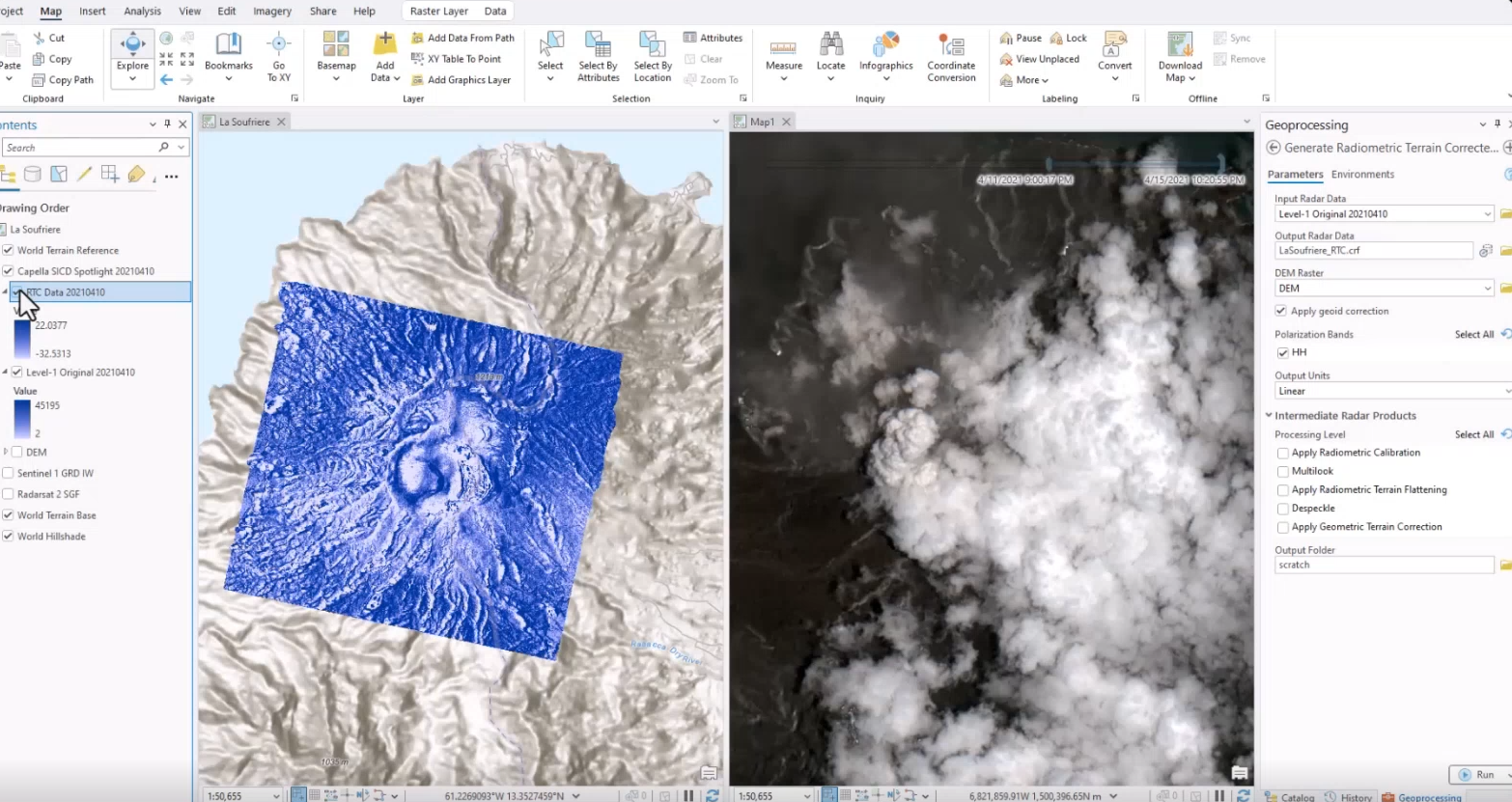
For Synthetic Aperture Radar (SAR) data, the Generate Radiometric Terrain Corrected (RTC) Data script tool is a significant enhancement. This tool transforms Level 1 SAR data into calibrated, terrain-corrected, and analysis-ready imagery. By abstracting away the complexity of SAR processing, the Generate RTC Data script tool makes these high-precision products more accessible to you.
Enhanced Deep Learning and Model Interpretability
Enhanced deep learning and model interpretability in the ArcGIS Pro spring release empower GIS professionals to achieve higher accuracy and reliability in their analyses. These improvements enable you to better understand and trust the models, which is crucial for navigating complex GIS applications such as land cover classification, vegetation analysis, disaster response, urban planning, and environmental monitoring. This leads to more confident and effective decision-making in these critical areas.
New GeoAI Enhancements
Understand model decisions with support for Grad-CAM
Grad-CAM, or Gradient-weighted Class Activation Mapping, is a visualization technique that creates heatmaps to show which parts of an image are most important for a model’s decision-making. With Grad-CAM support in ArcGIS Image Analyst, you can now see if the model is focusing on the right features. This helps improve the accuracy and reliability of your deep-learning classifications. Increased transparency means fewer errors and more trustworthy results, leading to better decision-making and planning.
Real-time model performance with TensorBoard integration
TensorBoard is now integrated into the Training Wizard on the Imagery tab in ArcGIS Pro. This integration lets you monitor and visualize your model’s performance in real-time, showing key metrics like loss and accuracy. It also gives you visual insights into the model’s structure and weights. This feature simplifies deep learning workflows, making it easier to understand, debug, and optimize your models, thus improving their overall performance and reliability.
Evaluate Pixel Classification accuracy with GP tool
The GP Tool for computing accuracy metrics helps you evaluate how well your pixel classification models are performing. You can now calculate important metrics like the confusion matrix, user and producer accuracy, the kappa index, and intersection over union (IoU). These metrics help you compare the model’s predictions with real data, giving you a clear understanding of the model’s accuracy. This tool is particularly useful for tasks like identifying different types of land cover, analyzing vegetation, and responding to disasters, where it’s essential to identify and correct any errors in the model.
New and Enhanced Support for New Data Types
In this release, we are adding support for diverse data types, which empowers you to leverage the unique strengths of each. By integrating these different data types, you can make more informed, timely, and accurate decisions across a wide range of critical applications, ultimately leading to better decision-making and more effective planning.
Newly Supported Satellite and Aerial Sensors in ArcGIS
Detailed hyperspectral imagery with Hyperion
We now offer detailed hyperspectral imagery from the Hyperion sensor. With 242 bands covering the VNIR and SWIR ranges, Hyperion delivers rich spectral information that enhances your insights with unparalleled accuracy and precision. This high spectral resolution, seamlessly integrated as a native raster type in ArcGIS Pro, is especially beneficial for applications like environmental monitoring, mineral exploration, agriculture, and disaster response.
Maxar WorldView Legion imagery support
There is now added support for Maxar WorldView Legion imagery, a cutting-edge satellite system that delivers enhanced Earth observation. With higher revisit rates, high spatial resolution, and multispectral capabilities, this system is ideal for monitoring dynamic scenarios like natural disasters, construction progress, and environmental changes, ensuring you have the most current information.
ArcGIS Pro now features processing templates for various WorldView Legion imagery types, including panchromatic, multispectral, pansharpened, and atmospherically compensated (AComp) products. These templates make it easier and more efficient to visualize and analyze the data within ArcGIS.
THEOS-2 imagery integration
ArcGIS now supports THEOS-2 Primary, Projected, and Ortho datasets, along with templates for Multispectral (4-band), Pansharpened, and Panchromatic imagery. This integration not only streamlines tasks like feature extraction, classification, and change detection but also significantly enhances your ability to visualize, process, and analyze high-resolution data from this advanced sensor, making your work more efficient and effective.
Vexcel Ultracam M3 aerial imagery support
With added support for Vexcel UltraCam M2, M3, and Dragon sensor data, you can now leverage large-format, high-resolution, multispectral aerial imagery. This integration comes with processing templates for panchromatic, multispectral, and pansharpened products, making it easier to visualize and analyze the data. As a result, you can complete tasks more efficiently and effectively.
Enhanced Support for Motion Imagery
Support for video file formats
For those using the ArcGIS Image Analyst extension, there is now enhanced support for AOMedia Video 1 File (.av1), M2TS Transport Stream (.m2ts), and Windows Media Video File (.wmv) formats. These formats are commonly used for aerial and satellite imagery, and the improved handling ensures that you can more effectively analyze and integrate video data into your projects. This is especially useful for applications like monitoring environmental changes, urban development, and disaster response, where real-time or high-resolution video data is crucial.
Improved PowerPoint templates and video multiplexer flexibility
There is significant improvement in the PowerPoint Template System and the Video Multiplexer. The enhanced ability to utilize video metadata and the increased flexibility of the video multiplexer will streamline the process of creating dynamic and engaging presentations, saving you time and enhancing your overall experience.
Streamlined Image Management
In ArcGIS Pro, we’re enhancing image management with streamlined tools and workflows that simplify the process of organizing, accessing, and analyzing large image datasets. These new features are designed to save you time and improve overall efficiency, making your geospatial projects smoother and more effective.
Enhancements to STAC Functionality
Add STAC items as single layers to reduce clutter
We’re excited to introduce a new feature that leverages the consistency and reliability of community standards. In ArcGIS Pro, you can now add STAC items as single, on-the-fly mosaicked layers. This reduces clutter and eliminates the need for a mosaic dataset in smaller collections of data, making your workflows more efficient and streamlined.
Expand data accessibility and security with tiled imagery layers
ArcGIS Pro now allows the ingestion of tiled imagery layers tagged as assets in a STAC catalog. ArcGIS tiled imagery layers are now accessible through STAC, broadening their reach and ensuring that you can benefit from imagery served as tiled layers. Additionally, this feature enables organizations to protect their data holdings behind image services, enhancing both data security and accessibility.
Improved Visualization Capabilities
Enhanced Visualization in Oriented Imagery
Overlay GIS features in Oriented Imagery layers
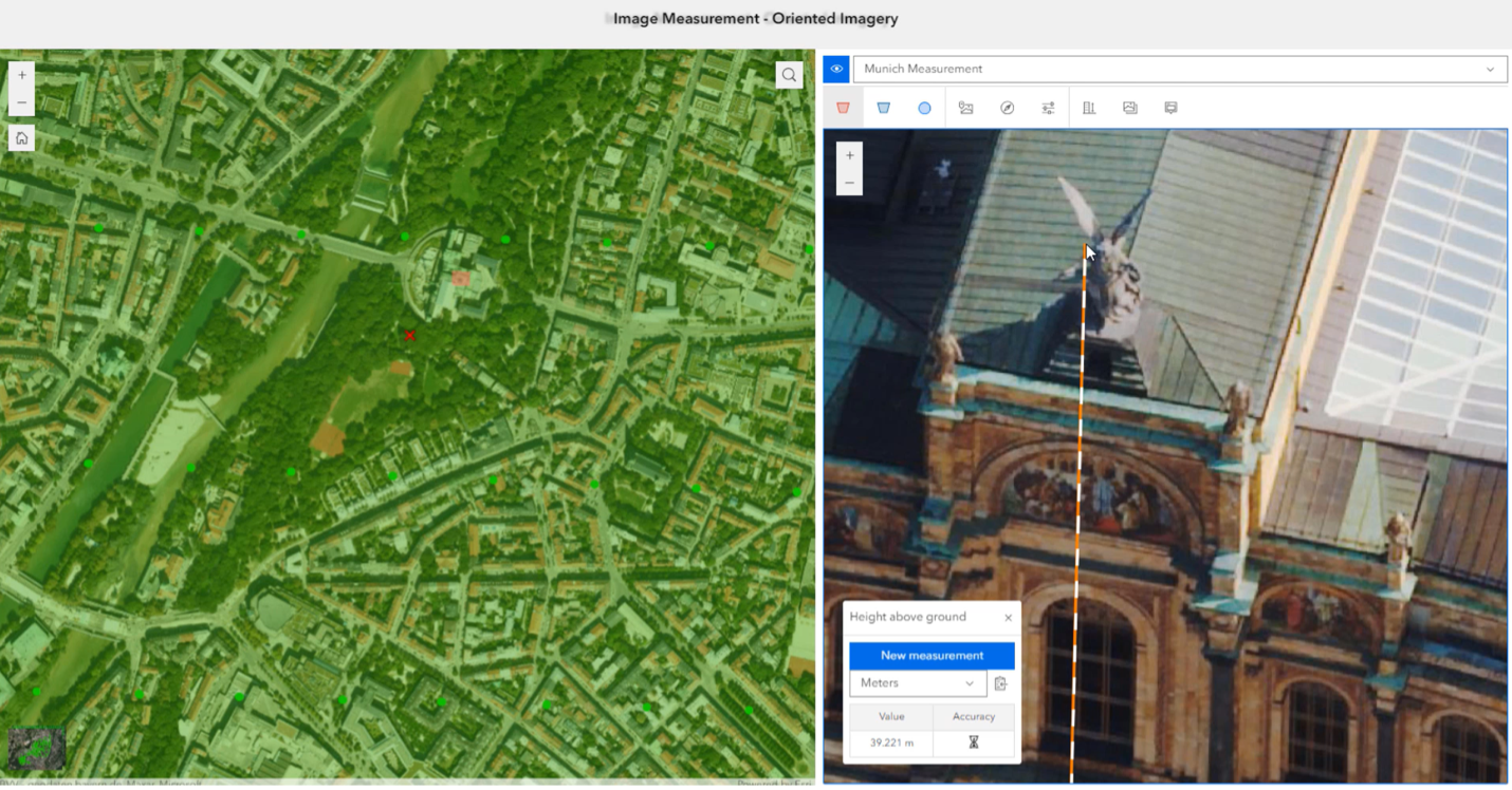
You can now display GIS feature data directly in the oriented image viewer, overlaying it on the imagery. Previously, ArcGIS Pro could show oriented images, however, it was difficult to align the imagery with GIS assets if the features were only visible in the map. This new feature ensures that existing features align perfectly with the imagery, making your work more accurate and efficient.
Enhanced Support for Stereo Imagery
Better feature visualization with Stereo imagery
The Image Analyst extension has made significant strides in enhancing the visualization and interpretation of features using Stereo imagery. You can now more accurately and efficiently interpret detailed features in your imagery, leading to better decision-making and analysis. Esri’s continued investment in this area has led to widespread adoption in National Mapping, Defense and Intelligence, State and Local Government, and Forestry.
Improved raster performance in Stereo Map
The Image Analyst extension has expanded its image enhancement capabilities for stereo models, with more options within the Symbology pane. Radiometric changes can now be made at a granular level to the red, green, blue, or near infrared bands. This enhancement, long requested by users, makes features within the imagery more interpretable, improving the accuracy and detail of analysis.
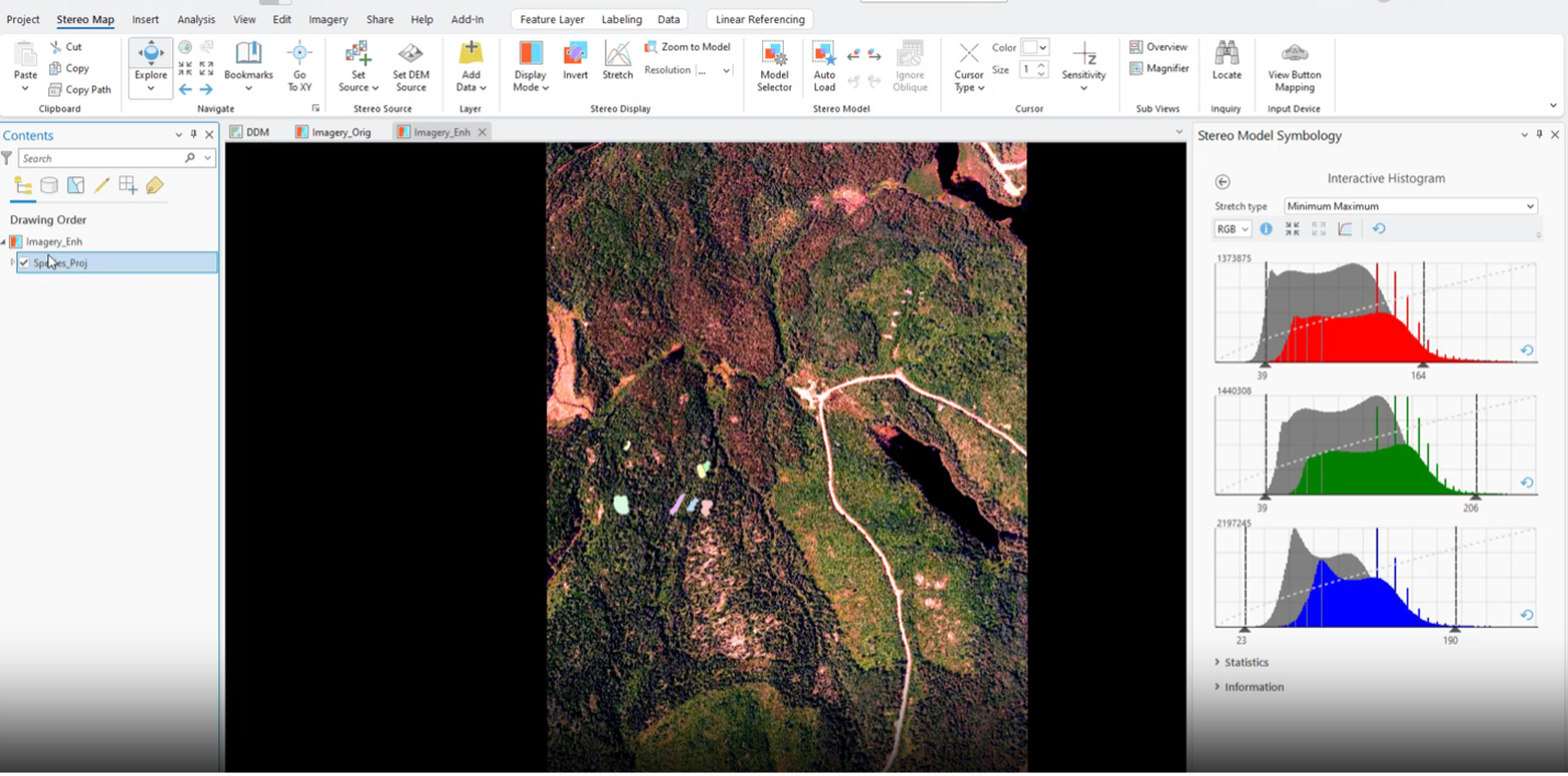
Expanded image enhancement capabilities
ArcGIS Pro has seen significant improvements in raster performance when working in the Stereo environment. Fast raster rendering in the Stereo environment is important for performing stereoscopic image analysis over wide areas and working with large imagery datasets, such as ADS or Leica DMC imagery. These enhancements ensure smooth and responsive performance, making the analysis process more efficient and effective.
Support for New Input Devices
Support for Stealth-V Type mouse
The Image Analyst extension now supports the Stealth-V type mouse, a widely used 3D input device in the defense and intelligence space. This support allows you to leverage familiar tools to enhance your stereoscopic analysis, improving workflow efficiency and accuracy.
The Spring 2025 release of ArcGIS Pro brings new features and enhancements that will streamline your geospatial analysis and data management processes. From advanced imagery analysis capabilities and enhanced deep learning tools to expanded support for diverse data types and improved visualization features, this release is designed to help you extract more meaningful insights from your data and optimize your workflows.


Article Discussion: