Early warning or assessment of potential damage is crucial for emergency response management to save lives and mitigate damages. Maybe you are an emergency management professional who is trying to make decisions on how to mobilize resources or wanting to send out warnings as a hurricane is moving in or floodwater is rising along rivers. Performing spatial analysis automatically as real-time data comes in will help you tremendously in your decision-making process.
This blog provides a sample ArcGIS Pro add-in and an example that simulates a use case in which all US counties affected by a hurricane are put on a map and charts are updated to show the affected population. And this all happens automatically with real-time data. Follow these steps:
- Download a Visual Studio project from https://arcg.is/0jH09i.
- Open and compile the project, and make sure there are no compile time errors.
- Press F5 to start. ArcGIS Pro opens.
- Open the ArcGIS Pro project that comes with the downloaded zip file inside the Data folder.
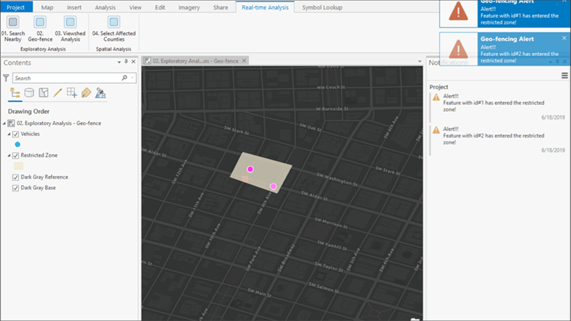
- Open the Spatial Analysis—Select Affected Counties map. You will see a polygon representing the cone of uncertainty of Hurricane Florence moving toward or over the US East Coast.
- Expand the Counties layer in the Content pane and open the chart associated with the layer.
- Click the Select Affected Counties button on the Real-time Analysis tab. You will see when the polygon is over the land—it automatically selects all counties intersecting the polygon.

The chart gets updated with the number of people who could be affected by the hurricane. You can click the 04. Select Affected Counties button again to stop this real-time analysis.
I have used a stream service that simulates this scenario using Hurricane Florence data. The sample code, data, and ArcGIS Pro project can be accessed at https://arcg.is/0jH09i.

Article Discussion: